

3 THINGS TO KNOW:
- Light snow Saturday morning
- Briefly frigid Saturday night
- Back in the 40s next week
FORECAST:
It will remain cloudy and cold Friday night with pockets of snow flurries possible. Lows will be in the lower 10s overnight.
Light snow moves very late Friday night, around midnight, and lasts until early Saturday afternoon. Most of the accumulating snow will stay north of Omaha, with highest amounts see on a line from Sioux City to Des Moines.

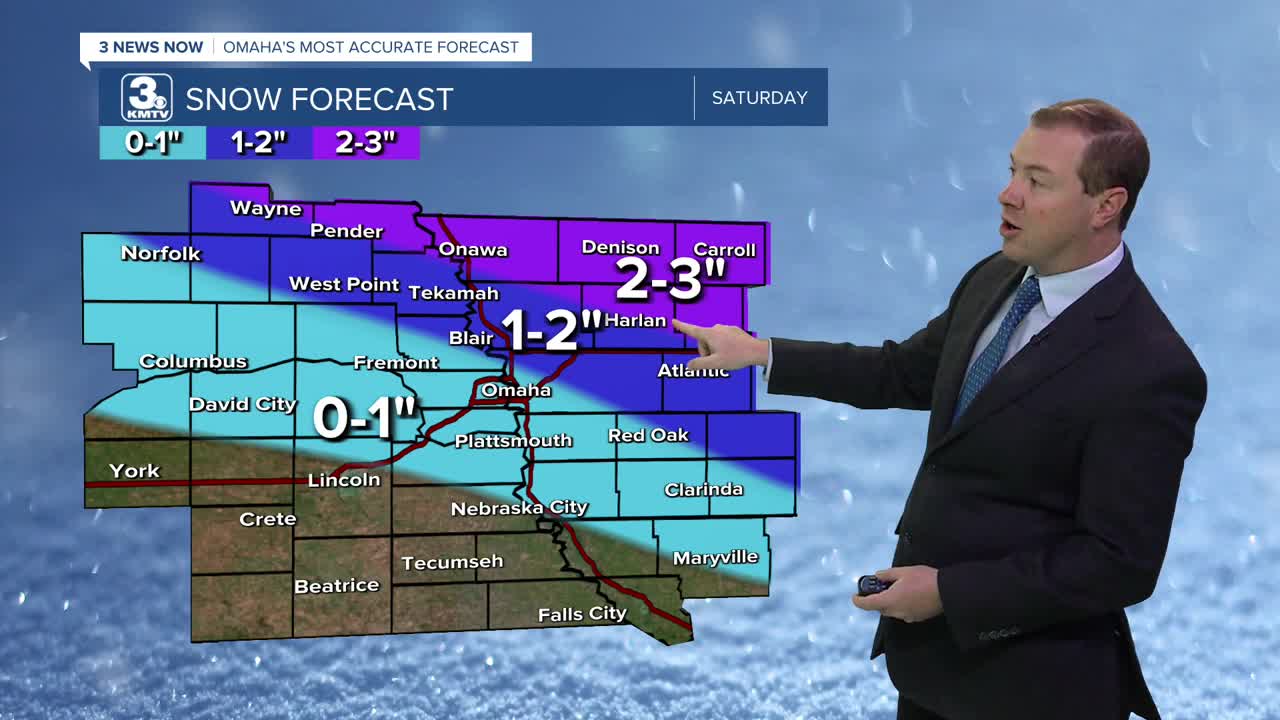
We have made some changes to the forecast and not everyone will see snow. Areas north of the Omaha metro have the best chance to get minor accumulations of around 1-2". The farthest north parts of our viewing area, near Wayne/Pender and Denison/Carroll will see 2-3" of snow. In between this and the metro, there will be a sharp drop-off in snow amounts. If you are along and south of I-80, including Omaha, it now looks like we will get very little snow at all, less than 1".
Highs on Saturday will be in the 10s with lows below 0 on Saturday night. Wind chills will be around -10 to -15 for Sunday morning.
By Sunday, skies will be mostly sunny and we are back to near 20 degrees.
Monday will be even warmer with sunshine and highs in the low 40s.
We have a chance at warming to near 50 degrees on Tuesday and Wednesday. Omaha's average high temperature for mid-December is 39 degrees. There is a small chance of rain in the middle of next week.
FRIDAY NIGHT
Cloudy
Snow after midnight
Low: 11
Wind: N 5-15
SATURDAY
Cloudy
Light Snow
High: 14
Wind: NE 10-15
SUNDAY
Mostly Sunny
Staying Cold
High: 19
Wind: E 10-15
Share your weather pictures with KMTV:
- Email to News@3newsnow.com
- 3 News Now Facebook page
- Use the hashtag #3NewsNow on Instagram or X (formerly Twitter)
