

3 THINGS TO KNOW
- Storms Tuesday night, Wednesday
- Severe weather possible
- Short cold-snap below freezing this weekend
FORECAST
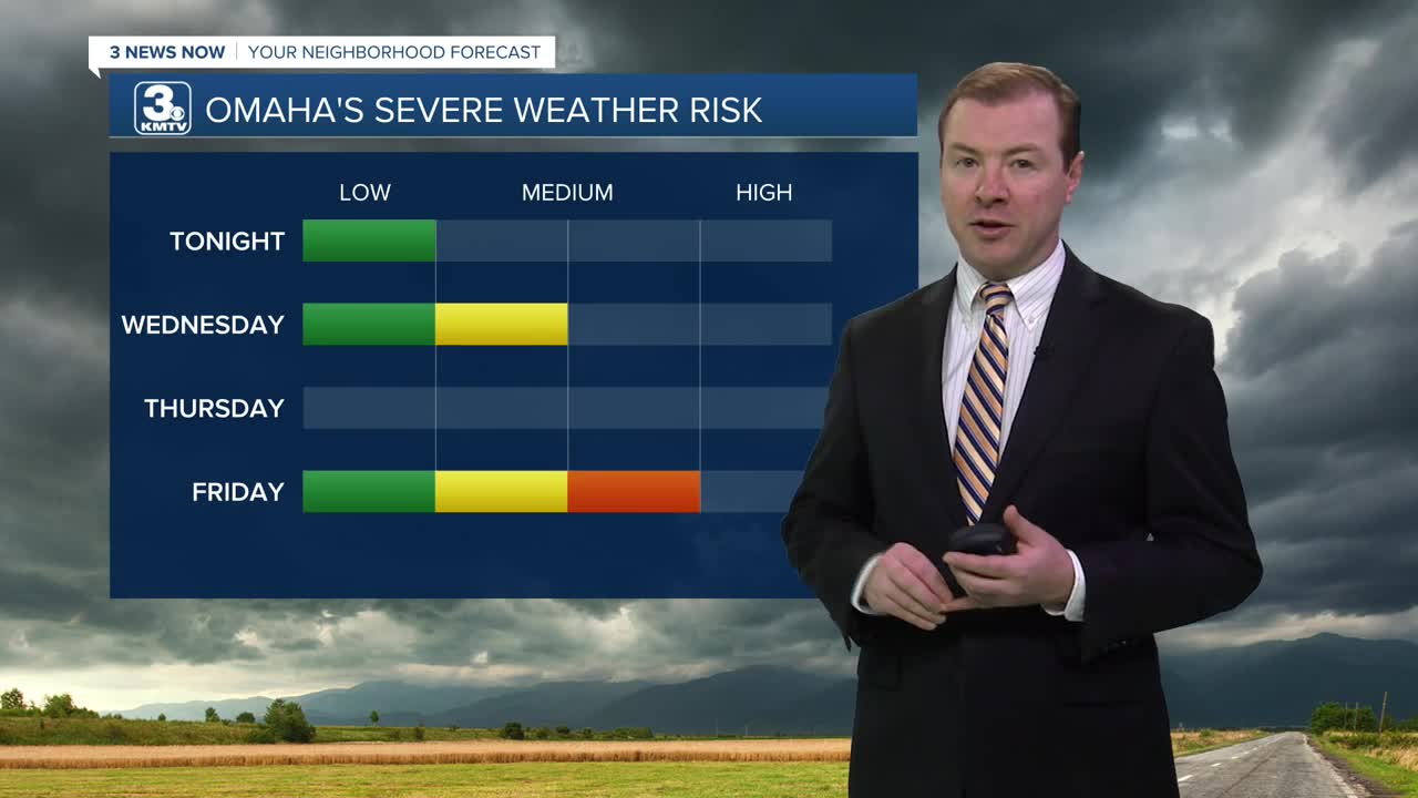
It will be a partly cloudy and mostly dry evening around Omaha. Later tonight, spotty storms will begin bubbling up across the Kansas/Nebraska border, moving across Omaha and western Iowa overnight. A few pockets of small hail may be possible, but the severe weather potential stays limited overnight. This rain will clear up by Wednesday morning.
We'll have several hours of drier, cloudy weather Wednesday morning, but there is a chance at more storms popping up later in the afternoon. Confidence has increased that these storms would be severe, capable of large hail and damaging winds. The timing will be from 2pm until 9pm across the Omaha metro and into western Iowa.
Dry, sunny and warm weather is back Thursday with highs in the mid 80s.
The final round of storms for the week are possible on Friday as a cold front sweeps through the region. This could also lead to a chance at severe weather on Friday afternoon. It will be windy! Temps will go from the 70s/80s on Friday, down to the 30s Saturday morning, and only in the 50s by Saturday afternoon. Winds could gust up to 45+ mph.
As winds settle Saturday night and skies remain clear, areas of patchy frost and freezing conditions are expected. Sunday morning will be around 29-32 degrees.
Sunday and next Monday will be dry, sunny and warmer with highs in the 60s and 70s.
TUESDAY NIGHT
Spotty Storms
Isolated Hail Pockets
Low: 56
Wind: SW 5-15
WEDNESDAY
Partly Sunny
Scattered Strong PM Storms
High: 75
Wind: SW 15-25
Share your weather pictures with KMTV:
- Email to News@3newsnow.com
- 3 News Now Facebook page
- Use the hashtag #3NewsNow on Instagram or X (formerly Twitter)
