
Tim Schmidt here! Get ready for another shot of cold, November air. And this time, it likely comes with an actual snowfall.
Here's what Joseph and I are following as of Tuesday evening, 11/25/2025. I'll take us through a more in-depth look at what we could see.
The Details
Weather forecast models (GFS and ECMWF) were not in agreement as of Sunday/Monday on the timing, location, or even winter precipitation type until today (Tuesday). We were seeing some WILD scenarios. Think about how much weather junk and 'hype-casting" you probably have seen on social media recently...
This happens often. The snowfall maps of 10-15" for an area may be nice "eye-candy", but can be frustrating for us.
We are now about 3+ days out.

The Saturday storm system is still over the northern Pacific Ocean, and over 2000 miles away from Omaha.
A lot can happen to 'nudge' this system north or south, or even speed up/slow down the system before it arrives. Once this arrives onshore sometime Thursday, we should have a very good idea on exactly how much snow/ice/rain/cold air, etc. we will see.
Joseph and I felt as of this morning there is now good enough agreement in the models' ensemble projection of this system to say Omaha should have an accumulating snow of 1", or more at some point this weekend.
A question I was asked by a viewer earlier this week was, "is the ground warm enough to prevent the snow from sticking?"
My answer, "probably not." The air will be in the 10s/20s leading up to the winter storm, which will likely lead to sticking, especially on elevated surfaces.
The Timing
This system will move in after Thanksgiving Day. Light snow showers will begin some time early Friday afternoon north and east of Omaha, followed by a light wintry mix developing in Omaha sometime Friday evening, which will continue off/on through Saturday morning. Depending on air temperature, this could lead to icy roads.

Air temperatures are expected to hold steady, if not rise at/above freezing (30-34º) Friday night as the system moves in. That will allow for mixed precipitation of rain, sleet and freezing rain to develop if this scenario occurs. North of Omaha, it likely stays as all snow. There is a scenario where dry air holds off all precipitation for a while longer.
At some point Saturday morning/early Saturday afternoon, cold air will begin to wrap into the system, changing all wintry mix over to snow through Saturday night.
How Much Snow For Omaha
We can better answer that when the storm system reaches Seattle, WA. Until then, ensemble forecasts from the GFS and ECMWF show good continuity on probability for snow.
The quicker (slower) the rain/wintry mix changes over to snow, the more (less) snow Omaha will see. (More snow time = more snow...more mixing = less snow)
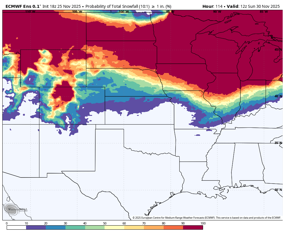
The chance we see 1" of snow in Omaha on Saturday is looking good, greater than 60%.
The chance for 2" or more of snow is 50%, and the chance at 4" or more of snow is 20%.
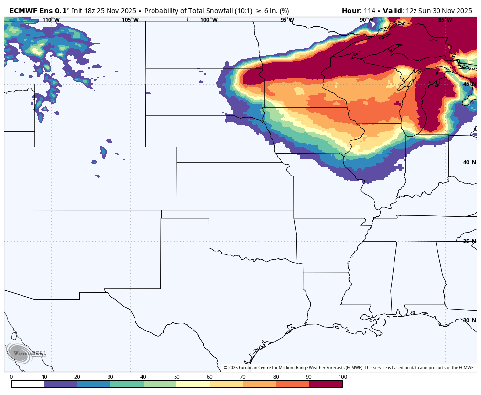
The chance for 6" or more in Omaha at a 10:1 liquid to snow ratio is less than 10%, until you get north of Carroll, Iowa.
Outside of Omaha, the chance for 3-4" north of Omaha does appear to be higher, (around 30-50%). While the the chance for more than 2" of snow south of Omaha appears to be lower (less than 50%) at this time.
The Cold
Once the snow is done Saturday night, it gets very cold! Nothing record-breaking though. Omaha's record lows are around -1 to -5 F for this time of year. We will be closer to 8 to 12 F by Sunday and Monday morning. We will probably see wind chills in the single digits, near zero Sunday, Monday and Tuesday.
There is another small chance for snow on Monday, but that system might stay in Kansas/Missouri altogether. We will see.
