

3 THINGS TO KNOW
- Frigid Monday
- Warmer weather returns later next week
- Greatest chance for rain/snow comes mid week
FORECAST
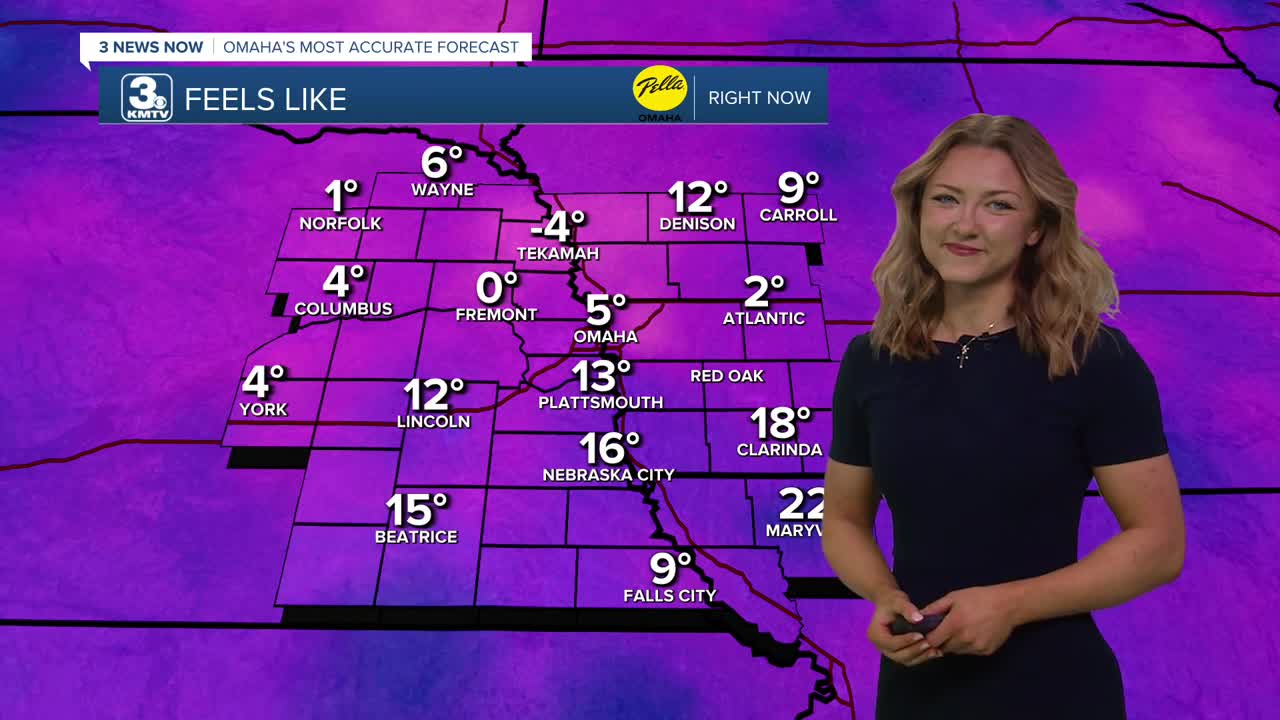
Monday morning isn't what a lot of us enjoy waking up to, with single digit - some negative! - temperatures.
Expect to climb only to about the mid 20s today. While we do have plenty of sunshine, a lot of that isn't going to boost our temps.
Tuesday sees a return to a common theme this February - warmer weather. Highs climb into the upper 40s where there is snow on the ground, and 50s where there is none. Clouds build in too, but we are dry.
Most of Wednesday will be dry and above average with highs in the upper 40s. By Wednesday night, a storm system zips past with some rain or snow, depending on the temperatures. Right now, we may be warm enough for mostly rain, but some snow may mix in north of I-80. This system will be fast, which will keep any impacts light as of now.
Despite the snow chance on Thursday morning, it pulls in some even warmer weather from the west. Thursday sees highs climb into the mid-50s with lots of sunshine.
Friday, we reach the peak of the warmth, reaching the 60s.
By the weekend, we start to drop into the 40s on Saturday, and the 30s on Sunday.
MONDAY
Mostly Sunny
Chilly
High: 29
Wind: SE 5-10
MONDAY NIGHT
Mostly Clear
Steady Temps
Low: 19
Wind: NW 5-10
TUESDAY
Mostly Cloudy
Warmer
High: 49
Wind: S 5-10
WEDNESDAY
Mostly Cloudy
Nighttime Rain & Snow
High: 45
Wind: N 5-15
Share your weather pictures with KMTV:
- Email to News@3newsnow.com
- 3 News Now Facebook page
- Use the hashtag #3NewsNow on Instagram or X (formerly Twitter)
