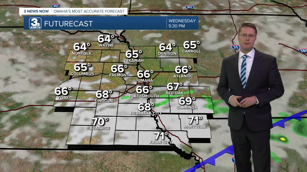


A cold front will continue to kick off hit and miss rain the rest of the afternoon, but only about half of us will see rain during the day. Omaha pushed into the low 70s for the lunch hour, but the cold front will drop us into the mid 60s by the drive home. We'll be mostly cloudy, but we could get a little more sunshine late in the day.
Wildfire smoke will also start to move in behind the cold front this afternoon, which thickens up tonight. This will likely impact air quality.
It will get chilly overnight! Omaha will fall into the 40s Thursday morning for the first time this season.
Thursday will be partly cloudy and warmer with mid 70s and lower humidity. While it will be a nice day, wildfire smoke will continue to impact air quality at times.
Another cold front moves in Thursday night. This one will bring some hit and miss storms, but only about half of us will get hit by the rain. This cold front will also clear out the wildfire smoke.
There could be a couple leftover showers south of I-80 Friday morning, but the rest of us will be mostly sunny. It will be breezy as cooler air moves in behind the front, dropping highs into the upper 60s.
Saturday will be mostly sunny with highs flirting with 70. If you're heading to the Huskers/Zips game in Lincoln, highs will be in the low 70s there.
Sunday will be mostly sunny with low 70s! A couple spotty showers are possible west of Omaha late in the day.
We keep a small chance for rain in the forecast Monday and Tuesday with mid 70s.
WEDNESDAY
Mostly Cloudy
Scattered Rain
Smoky Late
Breezy
High: 73
WEDNESDAY NIGHT
Partly Cloudy
Smoky
Low: 47
THURSDAY
Partly Cloudy
Smoky
Spotty Rain/Storms Late
High: 74
FRIDAY
Mostly Sunny
Breezy
High: 68
Share your weather pictures with KMTV:
- Email to News@3newsnow.com
- 3 News Now Facebook page
- Use the hashtag #3NewsNow on Instagram or X (formerly Twitter)
