

3 THINGS TO KNOW
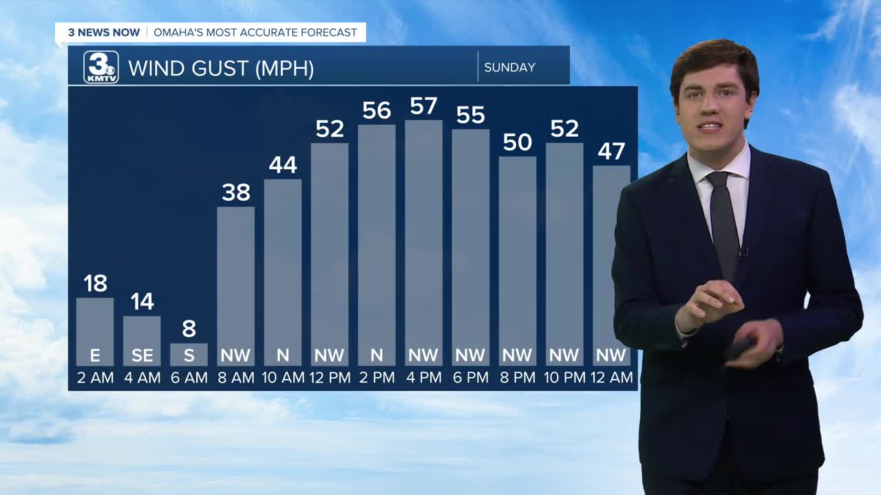
- High winds 60-70 mph on Sunday
- Blowing snow will create blizzard conditions
- Very cold heading into Monday morning
FORECAST
A major winter storm is expected to impact Nebraska and Iowa on Sunday.
The cold front arrives in Omaha around 8 am, dropping temperatures throughout the day. By Sunday afternoon, the temperatures will have dropped into the mid-20s. The cold front will also bring high winds to the region. Nebraska and Iowa could see sustained winds between 30 and 50 mph, with wind gusts of 60-70 mph. For context, a thunderstorm is considered severe with 58+ mph winds. Therefore, some broken tree branches or power outages are possible with the wind.
The wind will coincide with snow moving into the area. Snow begins in northeast Nebraska as early as 8 am and arrives in Omaha after 10 am. The snow will end from west-east by mid-afternoon, getting out of Omaha after 6 pm. The snow exits western Iowa after 9 pm.
Snow amounts will not be the big story with this storm system. If you can measure it, Omaha should expect to see 1-2", with higher totals to the northeast and lower totals to the southwest. Instead, the impacts will come from the wind. Blizzard conditions are likely at times as visibility drops to near-zero, creating travel issues for Sunday afternoon. Travel is not advised, and stay home if you can.
The final piece of the storm comes Sunday night. Though the snow is gone, the wind will stick around as temperatures continue to crash. We will wake up on Monday morning with lows in the single digits. Combined with a 30-40 mph wind, wind chills could fall as low as -15 during the morning.
The sun returns on Monday, but it's still cold with highs in the mid-20s. The wind will stick around, but slowly relax through the day.
Clouds move back in on Tuesday as another storm system slides by. Most of the snow will miss the region, but some precip is possible over western Iowa. Highs on Tuesday are warmer, in the low 40s.
Warmer weather kicks into high gear on Wednesday with the return of the 70s!
It may be hard to believe if you've read this far after our blizzard that we may hit our first 80 degree day later this week, but it's possible. The 80s continue into the weekend.
SUNDAY
Cloudy
Very Windy
Blowing Snow
PM Temp: 27
Wind: N 45-65
SUNDAY NIGHT
Mostly Clear
Windy
Low: 6
Wind: NW 20-40
MONDAY
Mostly Sunny
Breezy
High: 25
Wind: NW 25-35
TUESDAY
Mostly Cloudy
Warmer
High: 43
Wind: NW 10-20
Share your weather pictures with KMTV:
- Email to News@3newsnow.com
- 3 News Now Facebook page
- Use the hashtag #3NewsNow on Instagram or X (formerly Twitter)
