

A Tornado Watch has been issued for most of eastern Nebraska and western Iowa through 5 p.m. Tuesday, although the storms will likely be out of our area around 3 p.m. or shortly later. Severe storms in this area could produce not only large hail and damaging wind, but also a tornado. In fact, strong EF-2+ tornadoes are possible in western Iowa and northwest Missouri. Review your safety plan with your family and make sure you have multiple ways to get warnings.
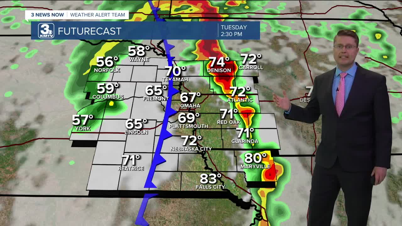
After starting the day with severe storms, a second round will arrive ahead of a cold front moving west to east through the region between 11 a.m. and 3 p.m. Tuesday. These likely go through the Omaha metro between noon and 2. The storms will be more hit and miss west of Omaha, but they will become more common and stronger as they approach the Missouri River and cross into Iowa and northwest Missouri. The severe storms could produce pockets of large hail, a few areas of damaging wind, and more flash flooding. Tornadoes will also be possible, but are more likely across Iowa and northwest Missouri, where they could reach EF-2+ strength.
Before the cold front and storms reach Omaha, we could warm up into the low 70s early Tuesday afternoon. Behind the cold front, it will be windy (20-40 mph) as cooler weather starts to blow in. This will drop us into the low 60s by the evening commute.
Wednesday will be a lot more quiet with some sunshine, lower humidity, and mid 70s.
Thursday will be warmer, with a high near 80. After a dry start to the day, another round of scattered storms will arrive later in the day and likely continues into early Friday morning.
We cool off into the mid 70s Friday, followed by low 70s on Saturday.
We'll keep a small chance for rain around each day of Memorial Day weekend, but rain looks a little more likely Monday. Highs will be near average, in the low and mid 70s.
TUESDAY
Mostly Cloudy
Severe Storms
Windy
High: 73
TUESDAY NIGHT
Partly Cloudy
Breezy
Low: 50
WEDNESDAY
Mostly Sunny
Comfortable
High: 76
THURSDAY
Partly Cloudy
Storms Late
Breezy
High: 80
Share your weather pictures with KMTV:
- Email to News@3newsnow.com
- 3 News Now Facebook page
- Use the hashtag #3NewsNow on Instagram or X (formerly Twitter)
Download the free Storm Shield app for iOS and Android phones
Receive severe weather watches and warnings for your location as you track the storms on radar. Great for use at the office, at home, and while traveling.
