

3 THINGS TO KNOW
- High wildfire risk over the next few days
- Warming until Monday
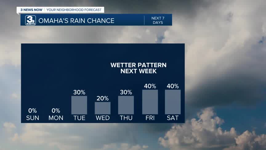
- Wetter pattern later next week
The National Weather Service issued Red Flag Warnings for Omaha and the region this weekend. The wildfire risk for around Omaha will be at high to extreme levels, especially Saturday. Emergency managers and authorities are asking residents to NOT burn this weekend.
FORECAST
The wind stuck with us for majority of the day, with gusts from the southwest reaching 35-45 mph. On top of that, most of us saw relative humidity values all the way down into the teens and single digits. You combine those two ingredients, and that creates a recipe for fire danger.
Sunday will be much warmer and less windy with upper 70s for highs.
Next week starts out warm, in the mid 80s on Monday.
A cold front reaches Omaha late Monday night, cooling things down in the 50s/60s for Tuesday, and kicking up a gusty breeze once again. There is a small chance at rain, but there's a good chance most of us will stay dry.
Wednesday and Thursday will be cloudy days with calmer winds and highs in the mid 50s.
The best chance at rain will be Friday and some of that rain could linger into Saturday of Easter weekend. This is a much-anticipated rain chance, and amounts are estimated around 0.20" to 0.50" from Friday through Saturday.
For now, Easter Sunday looks partly cloudy and mostly dry, in the mid 50s which is near normal for early April.
SATURDAY NIGHT
Mostly Clear
Windy
High: 43
Wind: S 25-40
SUNDAY
Mostly Sunny
Warmer
High: 79
Wind: S 15-20
MONDAY
Mostly Sunny
Hot
High: 87
Wind: S 15-20
Share your weather pictures with KMTV:
- Email to News@3newsnow.com
- 3 News Now Facebook page
Use the hashtag #3NewsNow on Instagram or X (formerly Twitter)
