Residents that live in or near the York area might have noticed some oddly strong wind gusts along with a large spike in temperatures, early this morning. The National Weather Service has decided that this happened because of a heat burst.
What Is A Heat Burst?
A heat burst is a relatively rare weather phenomena that happens at night. They are marked by a big increase in temperature, a rapid decrease in dew point, and strong wind gusts. Some of wind gusts can even be strong enough to cause wind damage to trees and property.
What Happened This Morning?
As scattered storms and showers were dying out near York; the cool, moist air falling from the clouds as rain, quickly evaporated in the downdraft. There was a layer of warm, dry air in place closer to the surface. Once the raindrops fell into this layer, the rain turned into virga. Virga is simply rainfall that never reaches the ground due to evaporation.
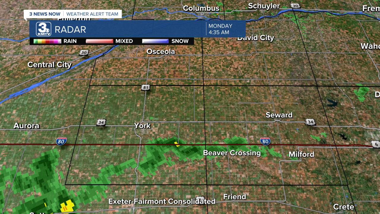
In fact, York Municipal Airport didn't record any type of rainfall while the heat burst was happening. Despite the radar picking up on the moisture in the atmosphere, it is very hard to prove whether or not any of it actually reached the ground. It very well could have turned into virga as it went through the evaporation process. All we observed was a spike in temperatures and wind speeds, along with a drop in dew point.
A dew point is a measure of moisture in the atmosphere. So, the higher the dew point, the higher the humidity. And vice versa.
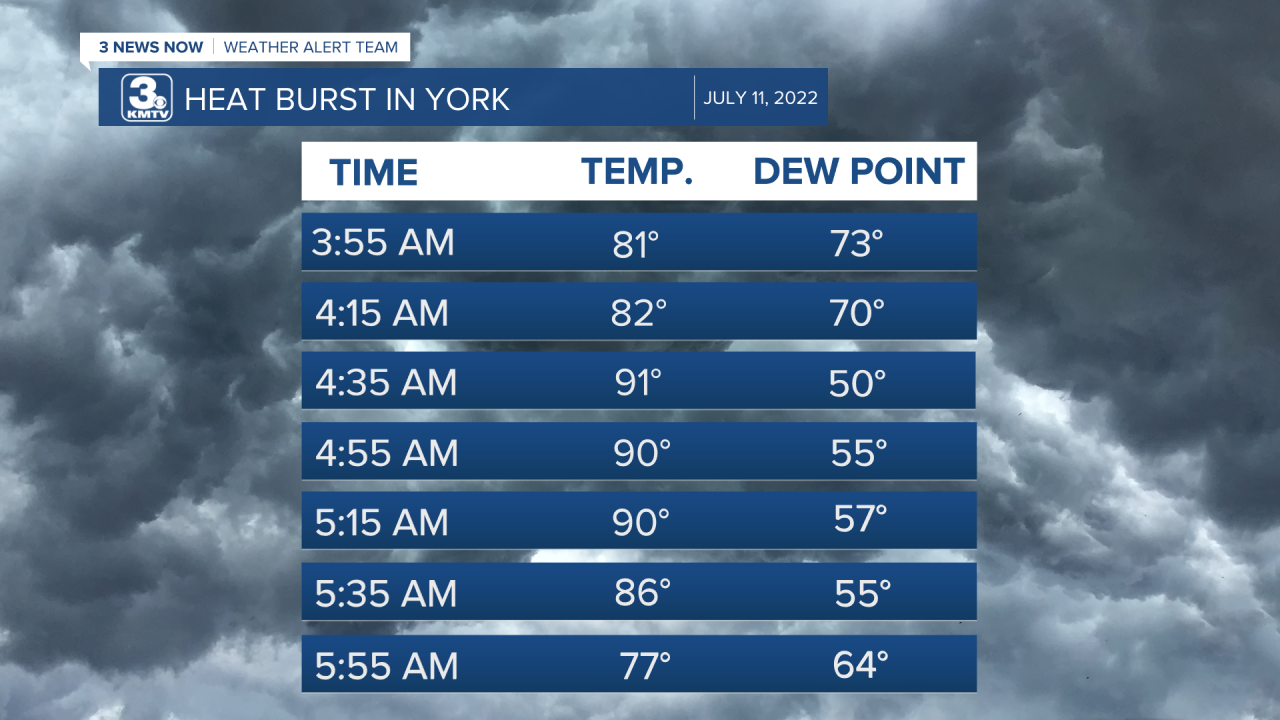
From the image above, we can see the highest temperature was recorded at 4:35 AM at 91°. This was accompanied by the lowest dew point measured this morning at 50°. York Municipal reported a 45 mph wind gust at this time, too.
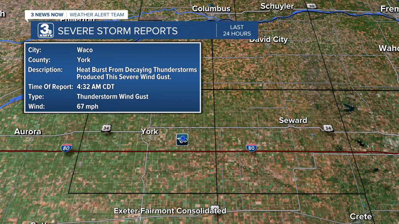
About 8 miles away in Waco, NE, there was a report of a 67 mph wind gust around that same time. This means that the heat burst was a fairly strong one.
What Are The Effects Of Heat Bursts?
The events that we observe on the surface is how we determine and identify most heat bursts. The sharp increase in temperatures, higher wind speeds, and large decline in dew points are all key giveaways.
A few of the negative side effects of heat bursts include very high temperatures. Some places have actually recorded temperatures exceeding 100°. Do keep in mind, this is an overnight event. So, there's no sunlight effecting the surface temperatures.
Heat bursts are notorious for producing very strong wind gusts. Wind speeds have been known to exceed 80 mph. This can easily cause damage to trees, roofs, lawn furniture, and overall property.
Can We Forecast Them?
Similar to severe weather, you have the ingredients in the atmosphere, but it is going to depend more on the atmospheric conditions directly over you at a specific time. Heat bursts are extremely hard to forecast for ahead of time. What we knew was going to happen overnight was scattered storms and showers. That is exactly what happened, too! However, it's dependent on the conditions throughout the atmosphere for each individual pocket of moisture.
As you can imagine, that would be exceptionally difficult to forecast. In reality, there are some heat bursts that happen across the country without us knowing about them! Since this morning's burst happened near a weather station, York Municipal, we were able to confirm what was going on. However, that leaves the problem of identifying heat bursts in areas that do not have a nearby weather station. That leaves us without any temperature, wind, and dew point data. We would have to inspect radar and possible damage caused by wind gusts if we think a burst happened.
