


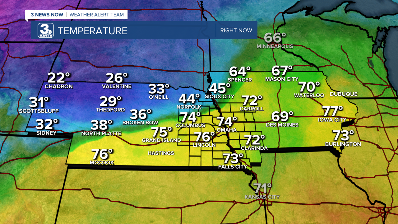
While most of our area is enjoying the record-breaking warmth as highs soar into the 70s and lows hold in the 60s, a glance to our north shows the future. A cold front was slowly sliding its way down into our area. It's already overtaken Norfolk and Wayne where temperatures are in the 40s this afternoon, but a short drive to Tekamah or Fremont and you're back to being warm. Temperatures over the western portion of the state look even colder, with afternoon temperatures in the 20s for some.
This cold front will move its way through Omaha tomorrow morning. We start the day in the upper 60s, but through the day we will fall into the 40s by the afternoon to end up in the teens overnight. This is a powerful cold front, but how usual is this for cold fronts? While uncommon for this much of a temperature swing, it is not completely rare. This blog post will show two examples of extreme temperature differences, including one of the strongest cold fronts in US history.
NOVEMBER 29-30, 2014
In recent memory, one of the stronger cold fronts witnessed in this region blew in on November 29-30, 2014. That afternoon, Lincoln and Norfolk reached record highs in the mid to upper 70s. The cold front came through during the late-night hours. In Norfolk, the high temperature was 77 around 3pm. By 3pm the next day, the temperature was 18 degrees! In Omaha the temperature change was a bit more muted, with highs tumbling from 66 to 22 in that same window.
NOVEMBER 11, 1911: THE BLUE NORTHER
To find some of the most extreme temperature differences due to a cold front in US history, you have to go back over 100 years to 1911. During the days of November 11-12, 1911, a powerful cold front swept through much of the US before moving out to sea.
In Omaha, the front moved through early in the morning, meaning our high was only in the 40s before falling. Where things got more extreme was in Missouri. Kansas City hit a record high of 76 before the front moved through, by midnight on the 11th the temperature dropped to 11 degrees. In St. Louis, the cold front was so intense it dropped from 74 to 49 in just ten minutes! Accompanying the front was a tornado outbreak in the Great Lakes where an F-4 moved through Wisconsin.


In the cold front's wake, much of the temperature was plunged into sub-freezing temperatures, with Omaha's low falling below 0 the night of November 12.


