
For eastern Nebraska and western Iowa, the end of June and the first couple of days of July have been wet, particularly along and south of I-80. Repeated rounds of showers and storms brought several inches to some regions. Did this help the drought? The latest drought monitor is in, and for once it's good news! Read more below.
RAINFALL RECAP
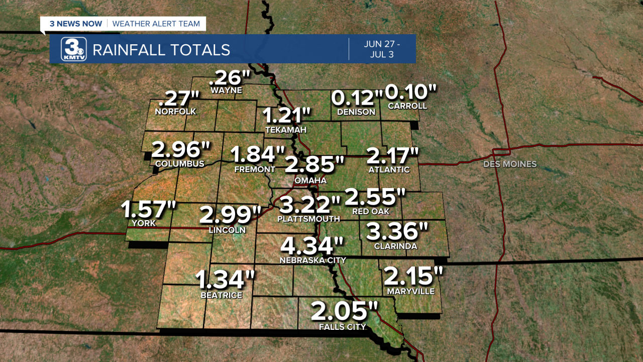
From June 27 to July 3, our region received beneficial rainfall from several rounds of thunderstorms. The biggest winners were those along and south of I-80, where in some instances between 2-4" of rain fell! Some locations picked up locally higher amounts, particularly from Platte County to Otoe County, where it is possible some picked up over 6" of rainfall!

Since July 1, Omaha has been running above average in terms of rainfall. This has helped us close the deficit gap in yearly rainfall, before this wet stretch, Omaha was running close to 6" below our yearly average. Now, we are 4.77" below that, we still have ground to catch up, but this is a good start! The average rainfall for the month of July is 3.63", so we are halfway to that.

LATEST DROUGHT UPDATE
At the end of June, the drought situation was getting worse. The exceptional drought, the level 5/5 category, was slowly creeping into the Omaha metro. Cities such as Ashland and Gretna were in that category, not to mention most of eastern Nebraska which has been in that exceptional drought for over a year. Drought was also worsening across western Iowa too.

The rainfall this past week has helped! For starters, the exceptional drought category was beaten back from the Omaha metro. It even was removed from Lincoln and Wahoo. Unfortunately, the rest of eastern Nebraska is still sitting in exceptional drought, but this is a good start.

NUMBERS FROM JUNE 27 TO JULY 4 IN NEBRASKA
No drought: 10.84% -> 18.25%
Abnormally Dry (Level 1): 89.02% -> 81.75%
Moderate Drought (Level 2): 74.97% -> 72.52%
Severe Drought (Level 3): 52.87% -> 48.63%
Extreme Drought (Level 4): 26.12% -> 25.48%
Exceptional Drought (Level 5): 13.15% -> 11.47%

NUMBERS FROM JUNE 27 TO JULY 4 IN IOWA
No Drought: 0.60% -> 0.48%
Abnormally Dry (Level 1): 99.40% -> 99.52%
Moderate Drought (Level 2): 89.15% -> 86.98%
Severe Drought (Level 3): 43.93% -> 43.52%
Extreme Drought (Level 4): 5.34% -> 4.71%
Exceptional Drought (Level 5): NONE
It is important to note that the drought this week does NOT include the thunderstorms seen on the 4th of July. With another rain chance tomorrow morning, we hope to continue to see this drought monitor improve!
