
Throughout the years, Omaha has experienced about every type of weather you can imagine from tornadoes to blizzards. However, no single weather event can compare to the December 15, 2021 significant weather event. It had everything from a major tornado outbreak, the largest in terms of numbers in Omaha's history; to very high winds causing large amounts of damage; to record high temperatures; to even dust, wildfires, and snow. This blog post will look back at this historic event in many ways.
THE SET-UP
5 days before December 15, a massive tornado outbreak swept through the Mississippi and Ohio River Valleys producing many violent tornadoes. Of the 77 tornadoes, one of those nearly destroyed the town of Mayfield, Kentucky. This airmass which produced the December 10 tornadoes was in part a similar airmass which moved north on December 15. It is nearly unheard of for this amount of moisture to be pulled this far north, it would take a very powerful storm system to pull this amount of air northward.
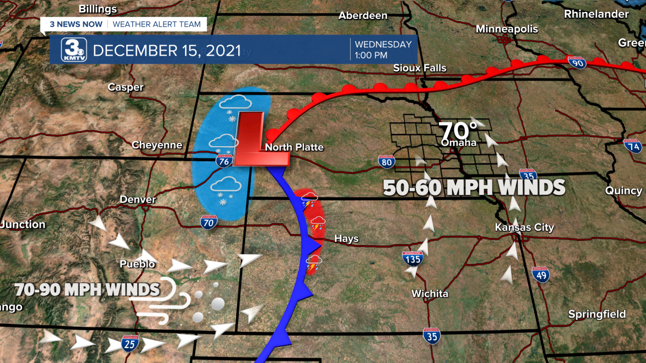
That is exactly what we had; a very powerful low-pressure system moved from Colorado into Nebraska during the day on December 15. The winds associated with that storm system were historic, winds around 5,000 feet were around 80mph, while winds around 18,000 feet were close to 140mph. For any typical December storm system, those winds are around half that strength.
THE WARMTH
The airmass being pulled northward was highly unsual, as represented in the extremely warm airmass for December. Omaha hit 74 degrees that afternoon! For context, before December 15 Omaha has only hit 70 in December three times in its history, with records going back to 1871. Not only did Omaha shatter the old record high of 61, but 74 now goes down in history as the warmest December date on record in Omaha.
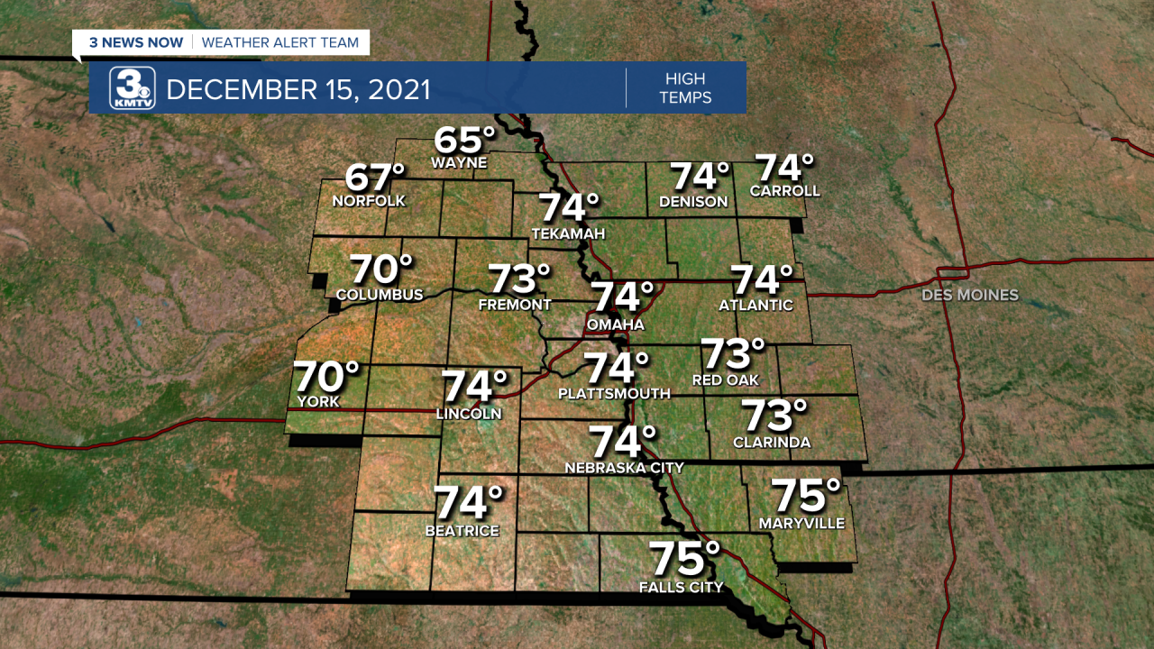
Many other locations across our viewing area hit the middle 70s, breaking records left and right. The warmth was not confined to Nebraska, with Iowa, Minnesota, and Wisconsin breaking the state all-time December highs!
THE STORMS
All that warmth meant the ingredients for a significant severe weather outbreak were in place...in December. Severe weather in Nebraska or Iowa in December is next to unheard of. Before 2021, only 5 tornadoes have touched down in Nebraska in the state's history, three of those being from Christmas Day 2016 near Kearney. In terms of Storm Prediction Center severe weather outlooks, the marginal-slight-enhanced-moderate-high scale you typically see in Spring, Omaha has never been in any severe risk during the month of December since 2002. On December 15, Omaha was in a rare moderate (4/5) risk for severe storms. To put this in context, the last time Omaha was in a moderate risk was in 2017!

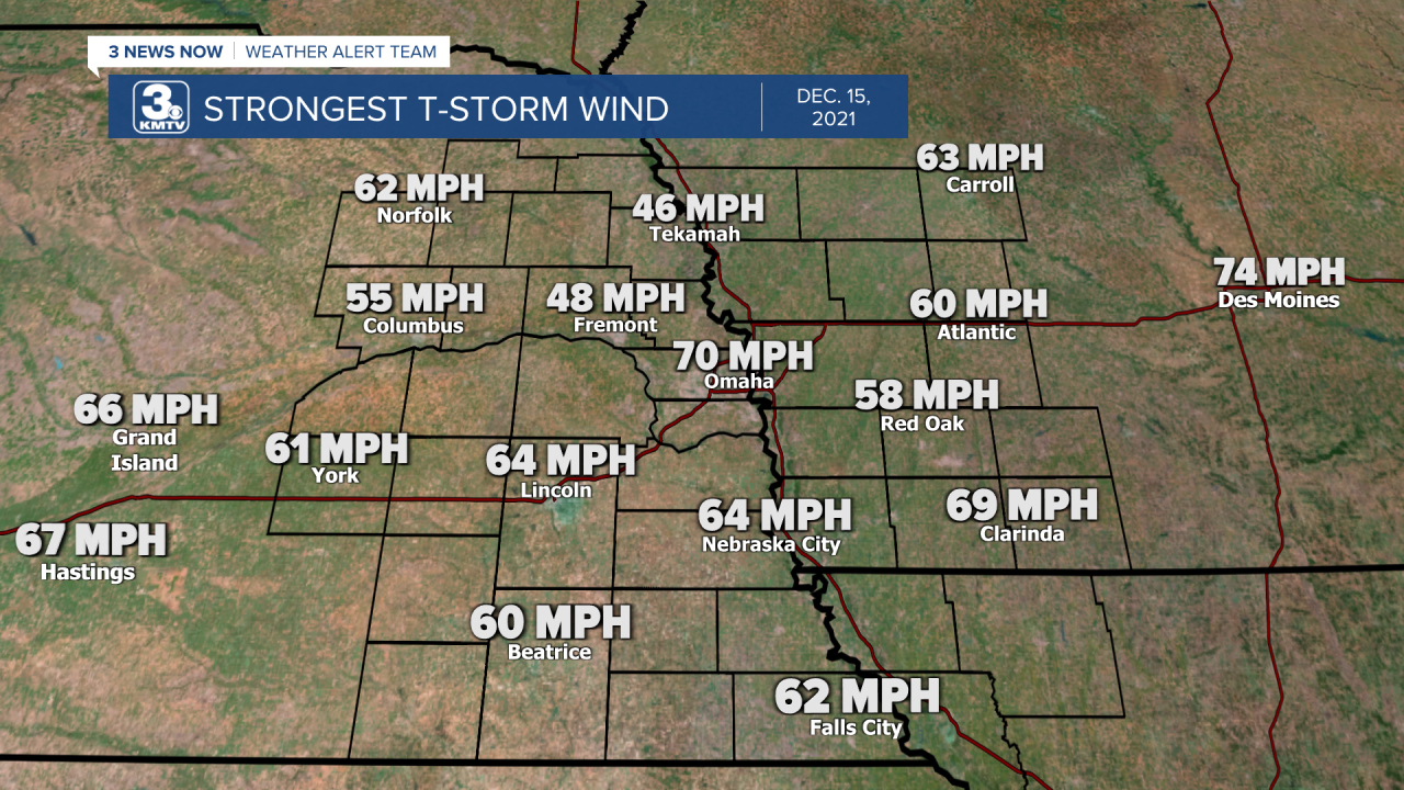
By 2pm a line of severe storms developed in Kansas and quickly raced eastward into Nebraska. Storms on average move 20-40mph through the state, but on December 15 storms moved 60-80mph!

Along the line we saw significant damaging winds upwards of 70-80 mph in many spots, with a few locations seeing over 90mph winds! Lincoln had the strongest wind gust at 93mph, which caused significant tree and structure damage in the city. Omaha had a max wind gust of 74mph as the line moves through, which also caused significant tree damage.

THE TORNADOES
In the 3 News Now viewing area, 32 tornadoes touched down within a span of a few hours. This is the highest tornado count in a single day in our area.

Of the 32 tornadoes, one was unrated in Crawford County IA, two were rated EF-0, eighteen were rated EF-1, and eleven were rated EF-2. The following list is a short summary of every tornado to affect the region:

- West Polk (Polk County) EF-1: Snapped power poles and overturned irrigation pivots.
- East Polk (Polk County) EF-1: Snapped power poles and overturned irrigation pivots.
- Platte Center (Platte County) EF-1: Destroyed a building on the southeast side of town.
- Columbus (Platte County) EF-2: Started in the center of town, destroying a roof off of a ranch home. It continued through the north side of town damaging homes before lifting.
 NWS Omaha/Valley
Garage suffered significant damage in Columbus  KMTV
KMTV6 seperate tornadoes moved across Cuming County - Howells (Colfax County) EF-1: Moved south to north through Howells, damaging a home and snapping trees. It lifted just north of town.
- SW Cuming County EF-2: Touched down NE of Howells, a barn was tossed over 100 yards away and destroyed other barns.
- 3 W of West Point (Cuming County) EF-1: Snapped power poles and caused damage to a shed.
- 5 W of West Point (Cuming County) EF-1: Brief tornado snapped a few power poles and trees in southern Cuming County, this tornado was just west of the previous tornado.
- S of Beemer (Cuming County) EF-1: Brief tornado caused minor roof damage to a home and destroyed a shed in central Cuming County.
- E of Beemer (Cuming County) EF-2: Widest tornado of the outbreak at 200 yards. Several well-built structures were destroyed.
 NWS Omaha/Valley
A barn was destroyed east of Beemer in Cuming County from an EF-2 tornado - Bancroft (Cuming/Thurston Counties) EF-1: A windmill was destroyed as was several sheds, one home lost shingles.
- Pleasant Dale (Saline/Seward/Lancaster Counties) EF-2: 22-mile-long path through three counties. One barn was pushed off its foundation in Lancaster County. Many more barns and homes were damaged from west of Crete to east of Malcolm.
 NWS Omaha/Valley
Barn heavily damaged in western Lancaster County from an EF-2 tornado - Yutan (Saunders County) EF-1: Moved through eastern Saunders County, prompting the National Weather Service Office in Valley to briefly take shelter. Barns and power poles were destroyed, closing Hwy 92 for several days.
- Ithaca (Saunders County) EF-1: Brief tornado to the west of the Yutan tornado. A cattle feeder was lifted and thrown 250 feet.
- 6 SW of Pawnee City (Pawnee County) EF-1: An outbuilding was destroyed, very brief tornado.
- Du Bois (Pawnee County) EF-0: Half of a large outbuilding destroyed west of Du Bois.
- 3 E of Pawnee City (Pawnee County) EF-1: The brief tornado removed a wrap-around porch from a home.
 KMTV
KMTVMultiple tornadoes moved through Cass County, NE and Mills County, IA south of Omaha - Avoca (Cass County) EF-2: Farm equipment was destroyed, and sheds damaged west of Avoca in southern Cass County.
- NE Otoe County EF-1: Very brief EF-1 snapped power poles and caused swirls in a nearby field.
- SW of Beaver Lake (Cass County) EF-2: A roof was removed from a house, while another house was moved from its foundation.
- Beaver Lake (Cass County) EF-2: Several homes on the north side of Beaver Lake was damaged.
 NWS Omaha/Valley
Many homes were damaged on the north shore of Beaver Lake from an EF-2 tornado - SW Mills County EF-1: Several outbuildings was destroyed near US 275 west of Malvern.
- NE Mills County EF-1: A roof off a metal building was torn off, several trucks were flipped on a farmstead.
- Council Bluffs (Pott. County) EF-0: Brief tornado was witnessed near the banks of the Missouri River in the floodplain south of Council Bluffs. No damage was noted.
- 4 W of McClelland (Pott. County) EF-2: Touched down just off I-80 before moving into the Sherwood Country Estates neighborhood where a few homes suffered damage.
- Neola (Pott. County) EF-2: Touched down east of Underwood before moving north into Neola. One home on the far east side of town had its roof removed and walls cave in.
 NWS Omaha/Valley
Many buildings were damaged in Neola, IA from an EF-2 tornado - Macedonia (Pott. County) EF-1: Touched down east of Macedonia. Some trees and homes were damaged along the track.
- Atlantic (Cass/Audubon Counties) EF-2: Long-track tornado moved just west of Atlantic, destroying several outbuildings near I-80 as it crossed.
 NWS Omaha/Valley
An outbuilding was destroyed near I-80 north of Atlantic from an EF-2 tornado. - Exira (Cass/Audubon Counties) EF-2: Paralleled the Atlantic tornado a few miles to its east, some structures were destroyed east of Exira.
- SW of Denison (Crawford County) EF-U: The "U" stands for unknown, as the tornado was confirmed using radar data, but no damage was seen at the location.
- Breda (Carroll/Sac Counties) EF-2: Tornado touched down in far northern Carroll County before moving out, several buildings suffered significant damage.
- Glidden (Carroll County) EF-1: The final tornado passed between Carroll and Glidden snapping power poles and damaging several buildings.
Outside of our region, these storms produced 120 tornadoes from Nebraska through Iowa into Minnesota and Wisconsin. This is the 4th largest tornado count within a 24 hour timespan. The three above are an outbreak on Easter Sunday 2020 from Louisiana to South Carolina; the April 3, 1974 Super-Outbreak from Alabama to Ohio; and the April 27, 2011 Super-Outbreak over Mississippi and Alabama.
NON-THUNDERSTORM WIND
The impressive wind fields above the surface also got brought to the surface in the form of very strong winds. Average wind speeds outside of any thunderstorms ranged from 45-65mph at times. In context, the classification for a "Severe Thunderstorm Warning" issued by the National Weather Service is 58mph, when winds can start doing damage. The fact that we saw these winds stronger outside of any storms meant widespread tree and powerline damage across the 3 News Now viewing area.
The maximum wind gusts recorded at Omaha outside of any storm was 70mph, meaning the non-thunderstorm winds were almost as strong as the actual storm winds as they moved through the Omaha metro.
DUST, SMOKE, AND SNOW

As the storms moved away, the very strong winds behind them caused all sorts of problems across Nebraska into Kansas. Dust was picked up in eastern Colorado and thrown as far away as Iowa and Illinois. Many of us saw a coating of dust on our cars the next morning as it moved through.
Many wildfires also were started in northern Kansas, with the smoke being carried into southern Nebraska. The largest fire was near I-70 in central Kansas, called the "Four-County Fire" which burned thousands of acres.
To top off the event, places in central and northeast Nebraska saw brief snowfall as the cold air poured in. In places such as Kearney to Norfolk, snow fell just hours after those same cities were under tornado warnings! Although snowfall totals were less than a half-inch, the strong wind created low visibility with whiteout conditions at times.
December 15, 2021 will be an event long remembered in Nebraska and Iowa for its variety of hazards and is a date which will be recorded in many record books.
