Although we typically do not think of August as a time when Omaha gets severe weather, it can — and has — happened in the past.
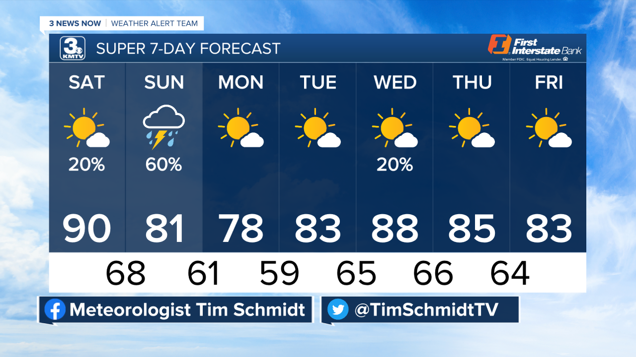
Our active weather pattern continues for the next few days with two potential rounds of strong to severe storms. The first round is isolated storms south of I-80 tonight, the second round is a more widespread chance for storms with a few strong on Sunday. Keep reading for the details below!
WHY ALL THE STORMS LATELY?
This is a question you might be asking yourselves ever since July when we seemingly flipped a switch to go from one of our driest stretches in recent history to a fairly wet period. The answer lies in the overall upper air pattern. This spring we were locked in what is known as an "Omega block" for much of May. This blocking pattern brought high pressure to dominate the central portion of the country, keeping us fairly dry. One exception was out in western Nebraska, where nearly daily storms brought some locations the wettest weather seen in some time.

By late June, the pattern began to switch. A large dome of high pressure developed over the southwestern US and hasn't moved for the past months. This is typical for the summer, sometimes coined by meteorologists as the "death ridge."
This "death ridge" usually expands further north to encompass Nebraska and Iowa during July and August, typically shutting down our storm chances and making us fairly hot. This year, the high pressure never expanded north, keeping our region in the northern ring of the high pressure. This kept on the stormy pattern known as the "ring of fire" where storm complexes develop over western Nebraska, roll through our area, and continue on into Iowa or Missouri. This has also brought a secondary benefit in keeping our summertime temperatures fairly manageable, with the exception of that one week in mid-July.
SEVERE WEATHER SUNDAY

Sunday is the day we are paying more attention to, but there still are questions about it. Sunday will set up much like today with a cold front working its way eastward through the KMTV viewing area on Sunday. While we could see a few showers and storms around Sunday morning, these are not expected to be severe and will move out by lunchtime.
Our severe weather chances on Sunday depend on how fast the cold front moves through the area, and that is not certain at this time. Two solutions look possible: 1.) Our cold front is faster, which confines the severe threat to areas southeast of Omaha, and possibly out of our area entirely. 2.) The cold front is slower, which brings the severe weather threat closer to Omaha and the rest of the viewing area. We will know more tomorrow once we gauge how fast this cold front is moving.


Regardless, wherever storms fire on Sunday they will probably go severe with an initial risk for large hail, damaging winds, and even an isolated tornado. Once these storms move further east, they should form into a line with mainly a wind threat as they move into Missouri.
Keep an eye on the sky on Sunday if you have any outdoor plans, as they could be impacted. As of right now, the timing looks to be afternoon and evening on Sunday, but it depends on the speed of the cold front.
STORM TRAIN LEAVES THE STATION
After Sunday, our pattern looks to change somewhat heading into next week. We look to enter a drier week with only a small chance for storms on Wednesday. Temperatures, however, should be kept in check with highs in the middle-to-upper 80s. This will change, so keep updated on our weather page or on TV for the latest forecast!