


In the run-up to Christmas 2022, much of the eastern half of the country was subjected to a major cold and snow storm which crippled parts of the country for the holidays. Blizzard conditions made travel hazardous across the Midwest as several inches of snow fell over the area, closing many highways and grounding many flights. What was more widespread was the brutally cold temperatures, with many cities shattering record lows. In Omaha, low temperatures reached -14 with wind chill values as low as -40 to -45, some of the coldest wind chills ever experienced at Eppley. The cold air reached as far south as Florida, where Tampa fell below freezing, and some snowflakes were reported in places like Daytona Beach. The December 2022 cold snap and snowstorm killed 106 people and caused roughly $8.5 billion in damage.

While experiencing the brutal cold of 2022, there was one month to which it was frequently compared to, December 1983. In the week before Christmas, the country fell into an icebox as freezing temperatures swept through the country. In Omaha, the month was full of unrelenting cold, nearly daily rounds of snow, and more. In this installment of This Week in Weather History, we travel back to December 1983 to relive the Winter that never seemed to end.
WHY WAS IT SO COLD?
As you might have heard before, our weather is largely driven by the jet stream. The jet stream is a belt of faster-moving air high up in the atmosphere that broadly separates the warmer air to the south and colder Canadian Air to the north. During the summer, the jet stream is pushed into Canada, leaving the US basking in the warm weather, but in the winter that jet stream dives southward into the US bringing the cold Canadian air with it.

Part of the reason why the jet stream dives southward in the winter is the development of a semi-permanent high-pressure system over the North Pacific. This high pressure forces the jet stream upward into Alaska, and in response, the jet stream dives southward over the eastern US.
Sometimes, the North Pacific High can become quite strong or develop much further north than normal, shoving the jet stream further north into Alaska and further south into the US. This is exactly what happened in December 1983, due to a series of atmospheric occurrences, the North Pacific high was thrust northward over Alaska proper, bringing warm weather to the last frontier during the month. In response, the jet stream was driven further south over the US. This remained the weather pattern for two weeks in December 1983, allowing the frigid arctic air to spill into the US uninhibited. The result was the coldest December on record for many locations.

DECEMBER 1983 IN OMAHA
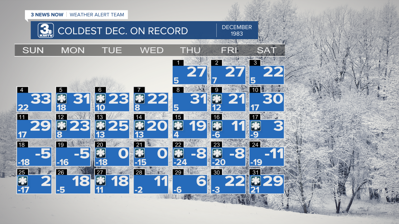
December 1-10
As Omaha entered the month, we were still dealing with the aftermath of the Thanksgiving Weekend blizzard of November 27-28 with several inches of snow on the ground. Temperatures remained below freezing for the first few days of the month, but on December 4 the temperature in Omaha climbed to 33 degrees for one hour. Little did anyone know at the time, but that one hour spent above freezing would be the only hour during the entire month of December. From December 5 to January 1, Omaha would remain below freezing. The 27-day stretch of below-freezing temperatures would be Omaha's 7th longest.

Into the middle of the month, temperatures were cold but bearable as highs remained around 30 degrees. On December 5-7, 1-2" of snow fell over Omaha, adding to the snow already on the ground. By December 10, 5" of snow depth was reported in Omaha as the snow did not melt.
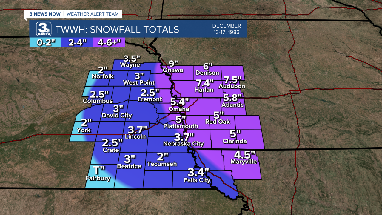
December 14-15: The First Cold Blast
On December 14, the first big cold front slid through the area, bringing the first foretaste of arctic air to the area. That day, snow fell over the metro, with Omaha picking up 3.5" on December 14 alone, along with an extra 2" through December 17, bringing a total of 5.4" to Omaha. The wind created blowing snow and caused reduced visibility and slick roads in eastern Nebraska and western Iowa.
As the snow fell, temperatures dropped into the mid part of the month. The high on December 17 was only 3, with a low of -6. Over the next few days, the temperature struggled to even hit 0 as the high on both December 18 and 19 was -5 degrees, lows bottomed out at -15.
December 20: Snow, then Brutal Cold
On December 19, a new low-pressure system was forming over the Rocky Mountains. With the frigid air ahead of it, it would have no problem producing snow. On December 20, snow began to fall associated with the storm system. Due to the extremely cold temperatures (the high on December 20 reached 0), salt proved ineffective against the snow, thus roads became hazardous in Omaha. Children had Christmas break begin early as many schools called off due to the snow. Rush hour commutes on December 20 came to a crawl, one commuter said it took them 90 minutes to get from downtown to 48th Street, taking Cuming St the whole way. In Omaha, 57 accidents were reported area-wide. In Council Bluffs, an 8-car pile-up occurred on I-80 near the Lake Manawa exit, injuring two people.
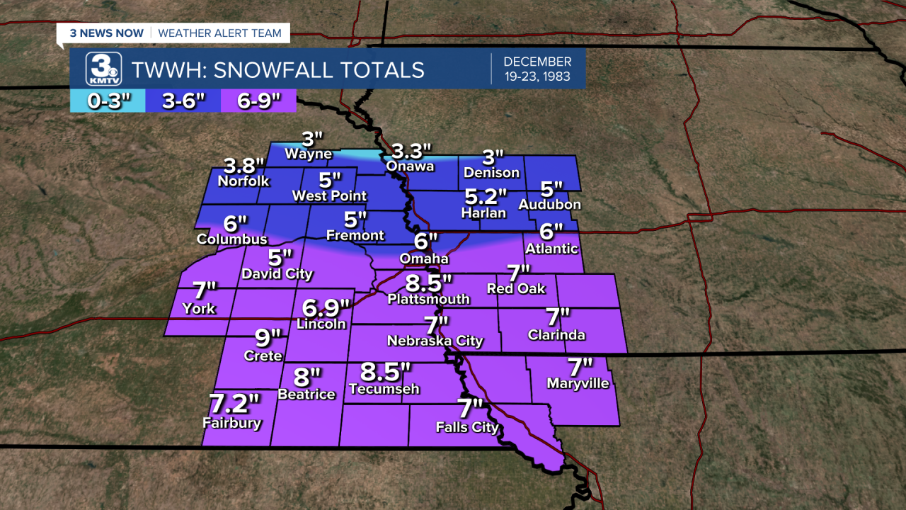
In total, 6" fell in Omaha, with higher totals further south. Since none of the snow melted so far, snow depths were measured as high as 14 inches in Omaha. Due to the blowing snow, some drifts across Nebraska were as high as 6 feet.
December 21-25: The Worst Week
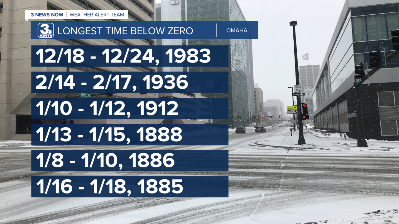
After the snow exited, Omaha fell into the coldest part of the already freezing nightmare. Temperatures that night plummeted to -18 degrees, barely rising to 0 on the 21st. Between the night of December 16 and the afternoon of Christmas, Omaha never rose above 0. This stretch of 7 days is the longest Omaha has ever been below 0 consecutively, not even the February 1936 cold wave or the cold snaps of the 1880s compare.
The icebox continued in the days leading up to Christmas. Highs on December 22-24 were -8, -8, and -11 respectively. The lows were outstanding, with the low on December 22 hitting -24 degrees. Combined with the wind, it felt closer to -40 to -50 in Omaha on the morning of December 22. The low of -24 degrees was the coldest temperature seen in Omaha since January 1912. The all-time low-temperature record in Omaha is -32 degrees set back on January 5, 1884. Since 1983, Omaha has only reached below -20 twice in 1989, once in 2018, and once in 2021.
Calls for stalled vehicles were commonplace across the region as the cold became too much for batteries to start. Pipes burst, leading to some water main breaks in homes and on streets. One water main break encased several cars in a multi-inch thick layer of ice at an apartment complex. Space heaters became overworked, leading to many house fires across Omaha. It became a struggle for firefighters to fight fires as the hoses would freeze, or fire hydrants refused to deliver water. Christmas shoppers bundled up in several layers just to venture outside, while heating centers reached record numbers of people seeking warmth.
The cold brought travel troubles due to the stalled cars, and de-icing machines for planes couldn't operate in temperatures that cold. As snow didn't melt due to salt, slick roads were reported for several days, leading to commutes being slow.
By Christmas Eve, it was the coldest day so far. The low that morning was -19, but the high only reached -11 degrees! This was one of the coldest days in Omaha's history since the 1910s. The word "record" quickly became a tired term as they continued to shatter: record cold highs, record lows, and even record high pressure were recorded in the span of a few days. Over 50 records were broken across Nebraska and Iowa.

By Christmas, celebrations of the holiday continued despite the cold. The high of 2 degrees was the first time Omaha had reached above zero in a week.
December 26-31: The Worst is Over
By the end of Christmas, temperatures rose to a balmy 18 degrees in Omaha. For the rest of the month, temperatures continued to be below freezing, but the temperatures climbed above 0 for most of the last week of 1983.
The below-0 temperatures did not escape completely, as the nights of December 28 and 29 still saw lows below 0, but nothing as had been endured the week prior. Some snow fell on New Year's Eve, but by New Year's Day 1984, the temperature rose above freezing ending the cold snap.
Unfortunately, the event did not occur without a death. On December 28, a woman was found frozen to death near downtown Omaha, this was the only fatality directly related to the weather in Omaha. One other fatality was recorded in Nebraska due to the weather when a car east of Hastings slid into a ditch, killing the driver. In Iowa, 4 people died due to exposure across the state, but none in western Iowa.
December 1983: In Context
As December 1983 fell into the rear view mirror as the world entered 1984, the true extent of the cold air became apparent. The average high temperature for December in Omaha was 15 degrees, the average low was 0.6 degrees, and the average for the month was 7.8 degrees. This made December 1983 the coldest December on record, and it wasn't even close. The second coldest December was December 2000 with an average temperature of 15.5 degrees. The average temperature for December in 1983 was 27.4 degrees.

In terms of snowfall, Omaha recorded 15.9" of snow for the month, over 10" above the 5.5" average for December. It is the 9th snowiest December on record for Omaha.
DECEMBER 1983 ACROSS THE NATION
Like Omaha, the first half of December 1983 across the United States was to be expected, it was cold but not overly cold. That changed when the first arctic front on December 14 sliced through the country with snow across the Midwest, 6-10" fell in Missouri, Illinois, and Michigan. Then snow started to fall across northern Texas and southern Oklahoma, a place where snowfall is rare in December. Dallas received up to 6" of snow, while snow as high as 8" fell in northern Texas, Louisiana, and Arkansas. It was one of the largest snowstorms to impact the south that early in the season.

As the next cold blast came through, much of the southern United States was not prepared for what was coming. Interstates from Texas to Maine were closed at some point or another, trapping many Christmas travelers in various destinations. Single-digit temperatures went as far south as Alabama and Georgia, even northern Florida froze with icicles forming on palm trees in the Panhandle. Even Miami on Christmas Day struggled to reach above 50 degrees.


The only location that escaped the cold snap of Christmas 1983 was the southwest, where locations such as Phoenix hit highs in the low 60s.

Tragically, the cold wave of December 1983 was deadly, particularly across the south. Officially, 151 people were killed due to the cold, many from exposure to the elements.

Although the cold snap six years later in 1989 was colder, it was not as widespread or as prolonged as the cold snap of December 1983, one of the deadliest in recent memory.
