


Although any form of winter weather is hazardous, there is perhaps no more destructive winter weather than ice. Even as little as a glaze, ice accretion can cause huge traffic problems. A recent example occurred in December 2016, when a glaze of ice fell from Oklahoma City to Baltimore. The hardest hit cities were places like St. Louis, where the glaze of ice caused major accidents on every roadway, and even forced a school district to keep their kids overnight. In Baltimore, a 70-car pile-up led to many fatalities. Just a glaze of ice caused all of this.
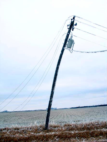
As the ice continues to accumulate, it begins to do damage. Trees snap, possibly landing on cars and homes. Power poles snap, causing power outages. These impacts can happen with as little as a tenth of an inch of ice. Any ice storm that creates over 1" of ice it becomes crippling to a region. While ice storms in Nebraska are relatively uncommon, the end of 2006 saw a major one that impacted central Nebraska. In this installment of This Week in Weather History, we look at the ice storm that brought central Nebraska to its knees.
WHAT CAUSES FREEZING RAIN?
In science class, you learn about the magic number, 32. The freezing point of water, once the thermometer hits 32 degrees at the ground, rain changes to snow. However, it is more complicated than that, as precipitation type depends on the temperature throughout the entire atmosphere from the cloud to the ground.

The two simplest are rain and snow. Rain occurs when the entire atmosphere is above 32 degrees, and snow occurs when the entire atmosphere is below 32.
Then there is sleet and freezing rain. Sleet occurs when the top half of the atmosphere is below 32, meaning the precip begins to fall as snow. As it approaches the ground, there is the presence of a warm nose in the middle of the atmosphere which is above freezing. This allows the snow to melt some, hitting the ground is ice pellets.
For freezing rain, temperatures in most of the atmosphere will be above freezing, but right near the ground, the temperature is below freezing. This means that the form of precipitation is rain, but it freezes on the cold ground into ice.
THE WEATHER SET-UP
For an ice storm, temperatures are crucial to any forecast. Late December 2006 did not have any arctic airmass moving in, thus temperatures over Nebraska from December 28 to January 1 were borderline. Highs in Omaha were in the 40s and 50s during the event until the snow moved in. Meanwhile, temperatures over central Nebraska were right at freezing, thus freezing rain fell.

For the last few days of 2006, a stationary front sat over eastern Nebraska into Iowa and wavered a bit but never moved south. Further south, a low-pressure system sat over Texas and Oklahoma for several days before lifting north into Kansas on December 30-31 finally allowing the cold air to filter in.


While it was around 32 degrees in central Nebraska, a few miles up in the atmosphere warm air was being fed into the system, pushing the atmosphere above freezing. For nearly 2 days, freezing rain fell over southern Nebraska allowing ice to accumulate to over 1" in spots.


As the low-pressure system finally lifted northeast, the cold air filtered in behind it allowing much of the freezing rain to change to snow. A band of heavy snow brought several inches to eastern Nebraska into western Iowa, allowing for an impressive satellite image showing two distinct bands of snow with the crippling ice storm in between.

DECEMBER 19-20: THE FIRST ICE STORM
Two weeks before the big ice storm, another ice storm crossed over the same areas which was to be affected later. In two days, between 1/4" and 3/4" of ice fell in south-central Nebraska, particularly impacting areas west of Kearney. In Dawson County, between Kearney and North Platte, some communities lacked power for several days as ice took out power lines. In the Tri-Cities, the ice wasn't enough to knock out power, but it was enough to snap tree branches across the towns.
Despite ice falling, ground temperatures were relatively warm, meaning the ice never froze to streets or sidewalks. West of North Platte, heavy snow closed I-80 from Big Springs to the Wyoming border, stranding holiday travelers across Nebraska for a time. Omaha saw mostly rain, with a few snowflakes mixed in before the system lifted.
DECEMBER 29-31: THE MAIN EVENT
Ice in Central Nebraska
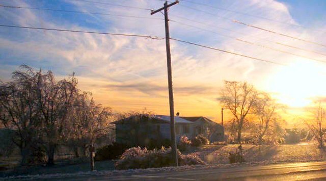
Between December 29 and 31st, freezing rain fell over much of central and southern Nebraska. The result was ice several inches thick coating much of the area from the Tri-Cities southwestward into southern Nebraska, producing one of the worst ice storms of the new millennium. Trees and power poles snapped, knocking out thousands of Nebraskan's power to ring in the new year. Trees crashed onto cars a homes, trapping many people from finding shelter to escape the cold homes. Schools, churches, and other centers opened up in towns where people could shelter from the weather.

The toll the storm took on Nebraskan power infrastructure was severe. Nebraska Public Power District (NPPD), the power company responsible for providing power to many of these communities in central Nebraska, felt the worst blow. According to their official survey, 37 high-voltage transmission lines covering 600 miles were destroyed in the ice. Over 6,000 power poles were snapped across the state, most of them concentrated in south-central Nebraska. 30 communities were knocked out of power completely, with even more seeing partial power being knocked out.
In the Tri-Cities, the ice was less severe but still carried significant impacts. Parts of Hastings and Grand Island were knocked out of power during the storm, but many of them were restored by New Year 2007. Power lines arcing during the storm started many fires, keeping the Fire Department busy for much of the storm. Roads were closed across Hall, Adams, and Buffalo Counties. It was worse in Kearney, where many spent New Year's in the dark, only to get their power back on New Year's Day.
In areas southwest of Kearney, some communities took days to get their power restored. On January 2, thousands were still without power from the Kansas border to Norfolk, many of whom live outside communities. Water systems could not work for farmers who struggled to nourish their cattle. Gas stations couldn't pump gas, leaving some without options to power their cars or get fuel for generators.

As NPPD worked to rebuild transmission lines, the communities still without power needed large generators to restore it. Shelters worked overtime for those in need, and people with power opened their homes to allow in those without it. In Kearney, rolling blackouts were instituted to not overload the power grid. Cities like Holdrege, southwest of Kearney, had some of their power restored by January 4 due to generators. Others continued in the dark for over 10 days after the storm. By January 4, 11,000 customers were still without power in Nebraska. That number was lowered to 6,500 on January 5 as generators arrived in towns around Kearney. One week later, many were still without power. Estimates show it took upwards of three weeks before power was fully restored to Nebraska.
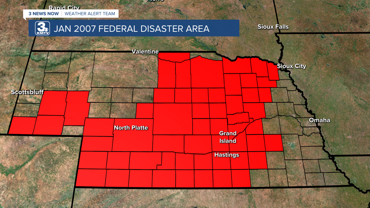
On January 7, the Bush administration declared 57 of Nebraska's 93 counties a federal disaster area. The state received $30,000,000 (45 million in 2023), which is slightly more than the total received from the previous 16 federal disaster declarations dating back to 1990 from 2006. It was truly a historic ice storm.
Heavy Snow in Eastern Nebraska
The ice storm was not comparable in Omaha than it was in eastern Nebraska. A glaze of ice caused some accidents in the metro, including a police officer who got in an accident on I-80. On New Years Eve, snow fell in eastern Nebraska as the cold air rushed in behind the storm. Snowfall totals in Omaha were between 2-4", with Valley picking up 5.6". Fireworks in downtown were delayed until January 1 due to the conditions, although many still celebrated the New Year as planned.

Snowfall was heavier southwest of the metro, where a narrow band of 7-10" formed from Jefferson County, through Lincoln, and into Saunders County. The heavy snow caused problems in Lincoln on New Year's Eve.
Overall, the 2006 ice storm was one of the biggest disasters in Nebraska seen so far in the 21st century. The cost to just utilities was $240,000,000 with the number higher if you factor in non-utility damages. Since 2006, no ice storm of comparable magnitude has impacted Nebraska.
