


Easter Sunday - March 23, 1913 - will be a day long remembered in Nebraska and Iowa. That day, multiple violent tornadoes devastated entire communities in the region. The most violent of them went directly through Omaha, causing a path of utter devastation. However, the Omaha tornado was but one of several violent tornadoes that struck close to one another. Towns such as Craig, Yutan, and Berlin (Otoe) outside of Omaha in Nebraska suffered extensive damage; as did Council Bluffs, Woodbine, Gray, and others in western Iowa.
This short series on This Week in Weather History will look in detail not just at the Omaha tornado, but at the entire day of destruction for Nebraska and Iowa. Part 1 will establish the background of the world of 1913, what Omaha and the US was like, the state of meteorology, and the atmospheric conditions that led to such a violent tornado outbreak. Part 2 begins by looking at the individual tornadoes, focusing on the tornadoes of eastern Nebraska. Part 3 (this part) examines the tornadoes recorded and unrecorded in western Iowa. Finally, part 4 takes a detailed look at the tornado which devastated Omaha. Take a look back at the tornado outbreak which shaped a region, 110 years ago this week.
TORNADO 1: TURIN, MONONA COUNTY
*This is a continuation of the Craig Tornado*

Turin was a smaller town in Monona County, east of Onawa. With a population of under 200, Turin was a small town nestled on one of the bluffs that characterize Monona County and the rest of western Iowa close to the river.
The Craig tornado crossed the river west of Blencoe, affecting mainly rural farmland before reaching Turin. The tornado weakened extensively at Turin, damaging 3 buildings but otherwise caused minimal damage in Monona County. There is no record of any further damage from Turin, meaning it likely lifted shortly after hitting the city.
TORNADO 2: WOODBINE, HARRISON COUNTY
*This is a continuation of the Yutan Tornado*

Named for the dense woodbine plant in the region, Woodbine was incorporated in 1877 as the second-largest town in Harrison County. In 1910, the population was 1,538 people; just edging out Logan with a population of 1,453 people. However, it was a far cry from Missouri Valley with a population of over 4,000. Easter Sunday celebrations went off without a hitch for the Harrison County communities, but many people in Woodbine noted the odd-cloud movements as it approached 6 pm.
The tornado, a continuation of the Yutan Tornado, crossed the Missouri River west of Missouri Valley, striking California Junction. Multiple homes were damaged at the Junction, with a few people injured. The tornado continued northeast, passing just west of Logan by a few miles. Two people lost their lives west of Logan, the final deaths of the Yutan tornado. This tornado continued further northeast, headed directly for Woodbine.
A clock at the Woodbine bank was stopped at 6:22 pm, the time the tornado moved through. It devastated the southern side of town, including the business section and multiple neighborhoods. According to contemporary accounts, over 50 structures in Woodbine were damaged or destroyed. Luckily, no one was killed in Woodbine, but several were hurt. The city would recover surprisingly quickly, and within a few months much of the business district was rebuilt.
TORNADO 3: CRESCENT, POTT./HARRISON COUNTIES
*This is a continuation of the Omaha Tornado*

North of Council Bluffs lies the small town of Crescent, best known today as the location of the Crescent Ski Hills, and nestled in the bluffs in western Pottawattamie County. In 1910, the population was a couple hundred people, only a short distance from Omaha and Council Bluffs.
The Omaha tornado crossed the river near Eppley Airfield, not built yet, and crossed into western Iowa. The tornado moved just south of Crescent by only a few miles, damaging several homes. There was more damage in Crescent from the Omaha tornado than damage from Crescent itself. The tornado crossed into southeast Harrison County, where three people were killed northwest of Neola.
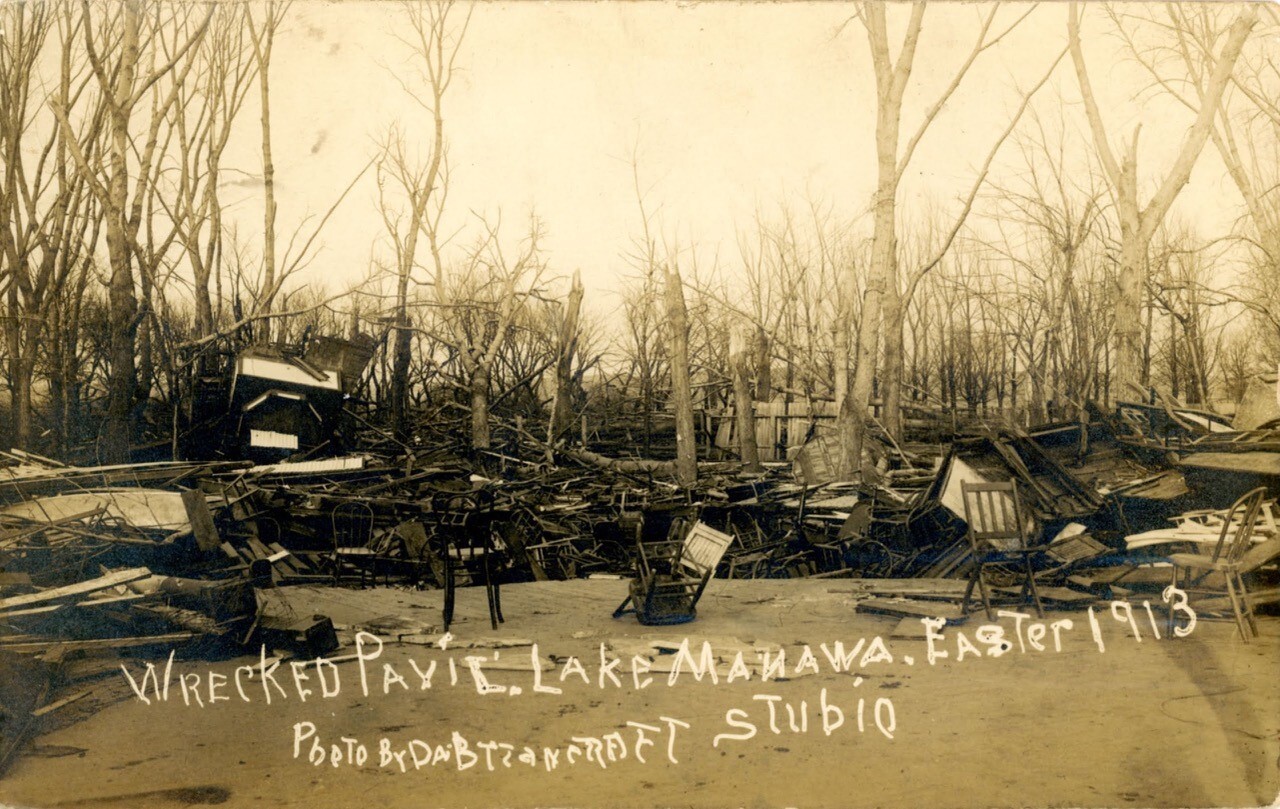
TORNADO 4: COUNCIL BLUFFS, POTTAWATTAMIE COUNTY
*This is a continuation of the Bellevue Tornado*
Situated across the river, Council Bluffs was a large town of around 30,000 people in 1910. It was the 7th largest city in Iowa at the time, one that continued to grow due to its geographic location along the river. The city came out to Easter Sunday services that morning, and like the rest of the region, people were heading home for dinner when the tornado struck the south side of Council Bluffs.
The tornado began in Bellevue and quickly crossed the river into Pottawattamie County, striking Lake Manawa. Many resorts and lakeside homes were wrecked along the lake. Boats were capsized or thrown into their docks. The tornado then clipped the far southern portion of Council Bluffs, missing much of the city. The destruction it wrought was significant, homes were destroyed, as were many buildings. Around 17 people lost their lives in Council Bluffs alone as the tornado passed by.
It continued northeast, paralleling what is today I-80 narrowly missing Underwood, Weston, and Neola. Three people died near Gillant as their homes were swept away. As it crossed near Weston, two more people lost their lives. Finally, the tornado passed near Neola, where the final fatalities of this tornado occurred. It dissipated near the Shelby County line. It was the third violent tornado to impact western Iowa.
TORNADO 5: MILLS COUNTY
*This is a continuation of the Berlin Tornado*

The Berlin tornado maintained its intensity as it crossed the river into Mills County. It missed much of the population centers of Glenwood, Malvern, and Henderson. In the rural communities, five people were killed across the county. It briefly would cross into Pottawattamie County before dissipating east of Macedonia.
THE OTHER TORNADOES??: AUDUBON/CARROLL/CRAWFORD/SHELBY COUNTIES

In official documentation of the tornado outbreak, many of the tornadoes are recorded in the first tier of counties along the Missouri River, but there is not much official record of the tornadoes further east. However, newspaper reports and photographs from west central Iowa suggest the tornado outbreak was much larger than originally thought with tornadoes continuing into Crawford, Carroll, Shelby, and Audubon Counties. Although these are unofficial, this is what I believe to be the paths of three distinct tornadoes based on research. One tornado went from Harlan through Gray and south of Glidden. Another tornado went near Defiance. A third tornado south of Denison and north of Manila, passing north of Carroll.
Harlan/Gray/Glidden Tornado
This tornado was probably spawned from the same storm that produced the Council Bluffs/Lake Manawa tornado. The tornado touched down just a mile and a half south of Harlan and moved northeast. Many homes were destroyed across eastern Shelby County, killing one occupant. The tornado then crossed into Audubon County, passing through the town of Gray. In Gray, many homes were destroyed and a few were injured, but no one was killed. The tornado then damaged a few barns in southern Carroll County, passing south of Glidden before dissipating somewhere in the county.


Defiance Tornado
What is probably spawned from the Omaha storm, a tornado passed south of Defiance in northern Shelby County. Newspapers at the time stated that the tornado was weaker than the one to the south, but the damage path was still consistent throughout the county.
Manila/Carroll Tornado
A few days before the tornado outbreak, a large fire broke out in the business section of Carroll, burning down several structures. As clean-up from the fire continued, Carroll was narrowly missed by a tornado that passed to its north. The tornado touched down in Crawford County, likely as the same storm that struck Woodbine. This tornado destroyed several barns in western Carroll County, where a few suffered minor injuries. In Mt. Carmel, the Catholic Church was shifted from its foundation. The tornado might have been mixed in with strong winds from the larger storm, meaning it might have been a weaker tornado. It lifted north of Carroll, possibly outside of the county.
SEE MORE:
Easter Sunday 1913 Tornadoes | Part 1
Easter Sunday 1913 Tornadoes | Part 2
