
Tuesday, May 21, 1918, was a day of celebration for residents in Carroll County. It was the wedding of Florence Rust to John Finnegan. Both lived near Maple River, just northwest of Carroll. The couple were wed at the Church in Maple River that Tuesday morning, then went to the Rust home for a banquet, attended by many of the neighbors. Within this jolly atmosphere, residents probably took note of the raging storm outside, but did not think much of it.
Yet, by the time many returned home from the wedding, they would find their lives upended. Many discovered they no longer had homes, as the thunderstorm contained a violent tornado that ripped through the countryside of Carroll County. Not only that, but the tornado was exceptionally rare in its intensity, it would be an estimated F-5 on today's scale.
The United States averages about 100,000 thunderstorms a year. Of those 100k, fewer than 1000 of them will produce a tornado. Of the roughly 1,200 tornadoes seen in the US each year, less than 1% of those are classified as F-5 or EF-5. To underscore how rare they are, as of writing this blog, there has not been a classified EF-5 tornado in the US since the Moore, Oklahoma tornado back in May 2013.
Had the scale existed in 1918, Carroll County residents would've had the distinction of living through one of the rarest tornadoes, but it would not have eased the suffering inflicted upon the residents. In this installment of This Week in Weather History, we chronicle another F-5 in the history books, the one that ripped through Carroll County.
THE SET-UP
The severe weather set-up on May 21 was not wholly unusual for the time. Though without modern meteorological tools, it's hard to reconstruct what fully happened on that day. The weather map that morning showed a large low-pressure system over Nebraska. Ahead of that low-pressure system was a warm front that was draped into Iowa. Warm fronts can often act as boundaries for tornadoes, as the wind change across them can be significant. Given the spatial significance of the tornadoes, it was likely a warm front that caused many of the tornadoes over Iowa.
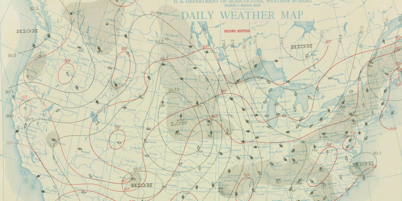
Storms fired along the Missouri River by early afternoon. A hailstorm near Council Bluffs caused damage to fields. To the north, a storm probably fired in the Onawa vicinity and moved east. Hail fell over Mapleton and Charter Oak. As the storm approached Denison, it became quickly tornado-like. This storm would be responsible for the F-5 to its east.
THE FIRST TORNADO
As the storm approached Denison, many residents looked to the west at the looming clouds and saw the first tornado form. This tornado, which has been estimated to be an F-3 by tornado historians, began north of Arion. The path of this tornado was short, less than 10 miles, but the damage it caused was significant.
At one home, the Houlihans were enjoying their afternoon when the tornado approached. Since it was visible, they were able to run out to the nearby storm cellar. Unfortunately, the family did not make it, and the tornado tossed them around. The father, Bryan, was thrown 100 feet and badly bruised. The rest of the family was knocked to the ground and pelted with debris. Amazingly, the entire family survived. Their house was not so lucky; the entire house disintegrated and was blown away.

As the house blew apart, one motorist was driving by in his wagon (or taking shelter) as the tornado passed over. The man, a Denison resident named Emmet Eling, was pelted with the home as his wagon was destroyed. He sadly would be killed, the only life taken in the Denison tornado.
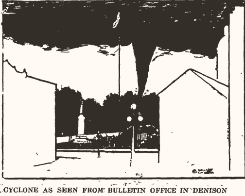
Inside town, residents began to panic as the tornado closed in. One man who worked for the Denison Bulletin sketched out the scene of the tornado heading for town. Thankfully, the tornado lifted about a mile west, and Denison was spared.
THE WESTSIDE/ARCADIA F-5
Although the Denison tornado lifted, the storm was far from over. East of town, it dropped the next tornado. Data across eastern Crawford County is sparse on any damage reports, but tornado historians place the beginning of the F-5 in the county.

The tornado would do its first major damage near Westside. The tornado narrowly grazed the town to the south, but farmsteads in the path were not spared. One farmstead on the Crawford/Carroll County line was destroyed, with only the foundation left. This would be the first of many instances of farmsteads disappearing in the fury of the twister.

A second farmstead southwest of Arcadia was also wiped off the map.

The tornado then barrelled into the southeast side of town. Within Arcadia, 15 homes were destroyed, a sizeable portion for a small town. St. John's Catholic Church was razed to the ground and had to be rebuilt. The nearby cemetery saw many headstones toppled or ripped out of the ground. The lumberyard south of town was destroyed as well. In all, Arcadia was deemed a significant loss. Though many were injured, no one was killed in Arcadia. This is perhaps due to the visible nature of the tornado, which allowed residents to heed the warning and take shelter.


East of Arcadia, the tornado would do its worst work. Home after home was levelled, with debris being strewn miles away. In one instance, a mattress was thrown over 2 miles! At one home, 8 occupants dove into the basement and hid under a pool table, and all survived.

As the tornado approached the Joseph Brincks farm, it would take a tragic turn. Joseph was home with his children, including 10-month-old Albert, and several helping hands. As the tornado hit, Joseph called for one of the helpers to hold the door so the wind would not blow it in. This did not work as the door from a nearby barn slammed into the house, opening it up and throwing everyone around. All were seriously injured. Joseph Brincks and his son Albert died in the storm, the two fatalities in Carroll County.

The tornado continued on its path of destruction through northern Carroll County, missing Maple River & Carroll to the north. Homes were heavily damaged, buggies were tossed, trees snapped, and dirt was torn up. 200 feet of railroad track along the Great Western Railroad was torn up. The tornado crossed into Greene County, where it killed two more people north of Churdan in a car. The F-5 tornado finally lifted near Adaza, only after destroying at least 20 homes, injuring 30 people, and killing 4.
THE OTHER TORNADOES
Tornadoes would continue farther to the east across central Iowa. One began south of Glidden in Carroll County and tracked over 30 miles before lifting. 2 people were killed. Outside the Arcadia F-5, another violent tornado (an F-4) moved over the southeast side of Boone, a sizeable town northwest of Des Moines. 9 people were killed, and 70 were injured. Tornadoes would continue toward Waterloo. The final violent tornado began in far northeast Iowa into southwest Wisconsin, where another 8 people died and 100 were injured.

Though not remembered much except for those who lived it, the May 1918 tornado outbreak in Iowa remains one of the more violent outbreaks in the state's history. The Arcadia F-5 is only one of 11 F-5s in the state of Iowa, and it lives on in the memories of those in Carroll County.
