
In terms of 24-hour snowfall data for Omaha, here is the general breakdown dating back to 1871: there are 88 days with snowfall above 6", 29 days with snowfall above 8", 11 days with snowfall above 10", and 1 day with snowfall over 18". That one day was February 11, 1965, when Eppley Airfield recorded 18.3" of snow, the snowiest day in Omaha history. The total snowfall from that day was 18.5", the second largest snowstorm in terms of the actual numbers. The largest snowstorm on record was 19.3" in March 1923, which you can read about here.
In this installment of This Week in Weather History, we look at the conditions that allowed 18" to fall in Omaha, and how the city fared.
THE METEOROLOGY BEHIND HEAVY SNOW
Winter forecasting can be challenging because there are so many variables that combine to produce the heaviest axis of snow. In certain snowstorms, snowfall gradients can be extreme where one town sees next to nothing, while the town over gets several inches. The ingredients that go into heavy snowfall forecasting are complex, but they can devolve into a few basic ingredients. Moisture, temperature, storm track, and instability.
Moisture is obvious, you need water content in the atmosphere to produce snowfall. The more water content the atmosphere holds, the more efficient the snowfall can be. Generally, the colder the air the less water content it can hold, and this is why colder temperatures generally produce dry snow while temperatures closer to freezing its typically wet snow. In 1965, temperatures were 20 degrees as the high temperature, with the low dropping to 8 degrees. The cold air meant the snow was a dry, powdery snow, which can accumulate more quickly than wet snow.
The other important factor in heavy snowfall is the storm track. Where the center of low-pressure tracks is crucial to snowfall. In 1965, Omaha might as well had the perfect track. The low-pressure system developed in eastern New Mexico then traveled across Oklahoma, Missouri, and into Illinois. This storm track is almost textbook for a heavy snow event in Nebraska and Iowa.

Instability is the most confusing, and most crucial, part of heavy snow. Normally, you might hear about instability when we refer to the "storm fuel" used in severe thunderstorms, but instability plays a part in winter too. Instability deals with how fast the air rises in the atmosphere. The more instability there is in the atmosphere, the more water content is lifted into the region most favorable for snowfall development. Instability can be very localized, as what happened in 1965. This area of instability lay from Fairbury to Lincoln to Omaha. For several hours, it puked snow with 2+" per hour rates being common. This was the ingredient that brought Omaha from getting 8" like a typical heavy snow event, to over 18", and some spots much higher.

THE ICE BEFORE THE SNOW
Two days before the big snowstorm, February 9, Omaha was hit with not a snowstorm but a major ice storm. Freezing rain began to fall across eastern Nebraska into western Iowa on the morning of February 9 as moisture from an incoming low-pressure system overran temperatures near-freezing most of the day. The result was an icy Omaha throughout the day.
Many Omaha schools except districts in Sarpy County cancelled classes that day. Those who had to go to work were caught in major slowdowns on many streets. At one point, Pacific Street was backed up from 72nd to 108th due to the ice. The I-680/Dodge Interchange had hundreds of cars backed up. Some cars slid into ditches, overwhelming law enforcement who were trying to respond to accidents. Bus services were delayed, as were many flights out of the airport.

Farther west, snow up to several inches piled on top of ice, causing several issues over central and eastern Nebraska. In Columbus, the city effectively halted as 4" overtop ice led to many streets becoming impassable. Rural roads were also impassable, preventing many from getting out. The heavier snow amounts were northwest of Omaha, with some locations like Stanton receiving over 6" of snow.
THE SNOWSTORM
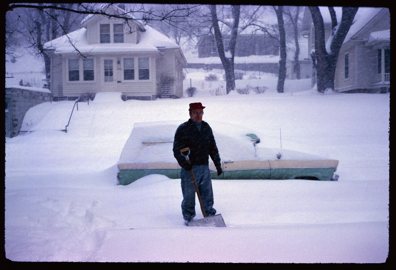
On the evening of February 10, forecasts called for more snowfall over Nebraska into Iowa. A second low-pressure system began forming in Texas and moved into Missouri, bringing snow to Omaha just before midnight. The snow then started falling...and falling...and falling harder. Between 6 am and 12 pm on the 11th, the snow fell at rates over 2" an hour from Omaha to Lincoln to Fairbury. By noon, over a foot of snow fell in Omaha, and by Midnight 18.3" of snow had fallen. The 18.3" in 24 hours is the highest 24-hour snowfall in Omaha history, dating back to 1871.

Within the first few hours, Omaha screeched to a halt. Schools that still had classes sent kids home by noon. Businesses closed by the evening. Bus and air travel ceased operations. Roads became a nightmare to drive on, and hundreds of vehicles across the Omaha metro were abandoned as motorists sought shelter in nearby locations. In response, public works pulled plow services that evening as the stalled cars became a deterrent to try to clear the roads.

By the next morning, the city remained silent as people were trapped wherever they stayed. Road crews came out in full force to clear the snow from roads that were not filled with stalled cars or jackknifed semi-trucks. The sounds of kids playing in the snow and shovels hitting the concrete rang throughout Omaha in the day following the historic storm. By the afternoon of the 12th, one lane on I-80 was opened, but the rest of the city remained stuck.

A record 19" of snow fell in Lincoln, creating many of the same problems that Omaha experienced. Roadways were closed, businesses let employees head home early, and schools were called off. Near Greenwood, between Lincoln and Omaha, the Van Hall family took in six-stranded motorists off of I-80. Two of those stranded people were Nebraska State Senators trying to get to Lincoln from Omaha. The group stayed overnight and publicly praised the Van Hall family in the legislature the next day when they arrived.

Southwest of Lincoln, the snow fell in even greater numbers over Saline, Gage, and southern Lancaster Counties. Crete and Wilber recorded 23" of snow, and Beatrice officially received 20", but snowfall amounts were even higher between those areas. In De Witt in southeastern Saline County, 29" of snow was recorded. Nearby in Clatonia, northwest Gage County, 30" of snow was measured. That 30" is perhaps the highest single-day snowfall total for anywhere in the KMTV viewing area in history. The huge snow amounts effectively cut off this region from the world for several days, it took until the weekend to finally dig out the smaller towns southwest of Lincoln.


In western Iowa, snowfall totals were less except for Pottawattamie, Harrison, and Shelby Counties. Still, problems occurred. Most of Council Bluffs was shut down due to the snow, and it took two days for even the main roads to open up. Similar situations happened in Harlan, where snowfall over 16" brought the city to a standstill. Even in places like Red Oak and Atlantic, where snowfall totals were a bit less, problems remained. For a time, I-80 was closed east of Omaha.

In the days following the snowstorm, the region slowly returned to normal. Main roads were cleared as residents collected their cars. Schools returned to classes, businesses opened, and bus services resumed. By February 15, after one of the biggest snowstorms to impact the region, Nebraska and Iowa returned to normal.
