


Normally, tornado outbreaks last a day or two. However, occasionally tornado events can last a lot longer if the right ingredients are in place. This is what happened from late May into early June 2008, where nearly every day had a significant severe weather event. The bulls eye was Nebraska and Iowa, with at least 6 different days with strong tornadoes. The outbreak sequence culminated in one of the more tragic tornado events in recent memory, the Little Sioux Scout Ranch tornado, which took the lives of 4 boy scouts. Learn about that event, a midnight tornado in Omaha, and many more in this installment of This Week in Weather History.
NOTE: Blue highlighted works link to specific videos of the tornadoes or damage.
MAY 25, 2008: THE PARKERSBURG IA EF-5

Our story begins on May 22, the first significant tornado outbreak. It mainly affected Colorado and Kansas. A large tornado moved through Windsor CO north of Denver, and other large tornadoes occurred outside of Goodland KS. Western KS was the focal point of another major tornado outbreak on May 23, where a few violent tornadoes occurred over largely open areas.
After a lull in activity, severe weather ramped up significantly on May 25, this time targeting northeast Iowa. That afternoon, a massive EF-5 tornado tore through the community of Parkersburg. The tornado moved through the southside of town and continued into the nearby town of New Hartford. A metal building was so destroyed the metal frame was mangled and sheared away, in a heap away from the building. Homes between Parkersburg and New Hartford were completely swept away, leaving only basements and foundations around. The tornado took 9 lives and injured 70 others before lifting north of Waterloo.
MAY 29, 2008: CENTRAL NEBRASKA TORNADOES

After a few days of rest, severe weather returned to the region on May 29. A High Risk of severe weather was issued by the storm prediction center for the possibility of strong tornadoes over central into eastern Nebraska.

By the afternoon, one supercell developed south of North Platte and continued down I-80 producing multiple tornadoes. The bulk of the tornado activity occurred near Kearney, where three seperate tornadoes caused damage in and around the town. Other tornadoes touched down near Aurora and York, both of them producing damage.

Further south, an EF-3 tornado touched down in northern Kansas, crossing the Nebraska border into Jefferson County. This tornado narrowly missed Fairbury to the north as it did damage in the southwest corner of Jefferson County.
Other small tornadoes touched down in western Iowa from more storms, but the Omaha area was spared the worst of the damage.
JUNE 4, 2008: EMERSON IA TORNADO

After another few days of rest, more tornadoes affected eastern NE and southwest IA on June 4. Supercells developed along a warm front which was draped from Grand Island to just south of Omaha to Red Oak. Storms produced tornadoes in northern Seward County and southern Saunders County in Nebraska; and Mills, Montgomery, and Adams Counties. One of these tornadoes moved south of Emerson, documented by several storm chasers, this tornado was an EF-1. Property damage from these tornadoes was minor in most cases.
JUNE 5, 2008: TORNADOES SOUTHEAST OF OMAHA

June 5 was another high-end day for severe weather. A high risk was issued by the Storm Prediction Center which included much of eastern NE into western IA, where the possibility of high end tornadoes was there.

Luckily, storms that developed over Kansas early sucked the energy from the air, leading to less tornadoes. However, in areas where tornadoes did touch down they produced damage.
The strongest tornado of the outbreak occurred northeast of Falls City, this EF-2 tornado crossed the Missouri River into Holt County MO where it narrowly missed the town of Corning. Other tornadoes produced damage east of Red Oak in southwest Iowa.
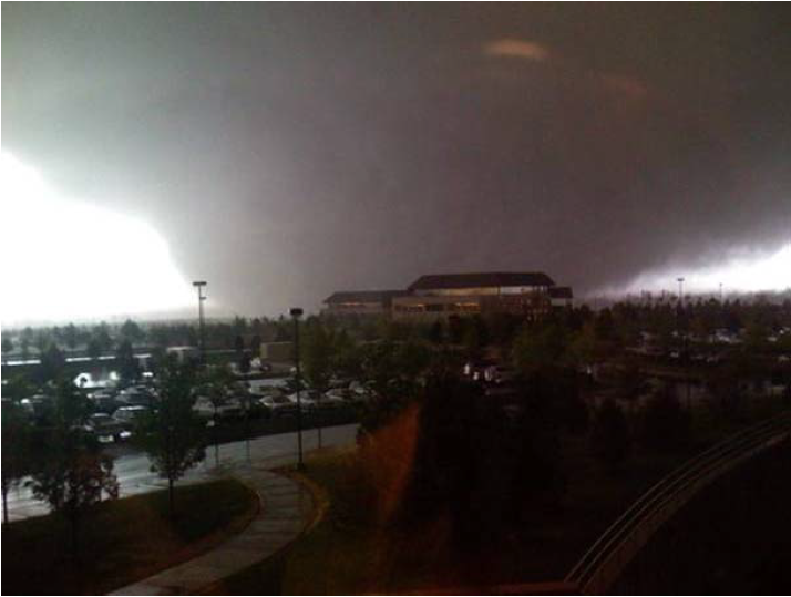
JUNE 8, 2008: THE MILLARD TORNADOES

The storms from May into early June 2008 largely missed the Omaha metro, but all that changed in the early morning hours of June 8. Sleeping residents in Gretna and Millard awoke to the sound of roaring winds, and soon a tornado was upon them. In fact, two tornadoes ripped through southwest Omaha that night.
The first tornado touched down near 232nd St and West Angus Rd near Gretna. Doing damage on the north side of Gretna, the tornado intensified to EF-2 as it crossed into southwest Omaha and Millard. The most concentrated areas of damage were to the region around 156th and Giles and 132nd and Y St. Homes had their roofs torn off, trees snapped, power poles destroyed, and cars flipped. This tornado actually merged with another tornado also doing damage in southwest Omaha.

The second tornado touched down near 204th and Q St where it damaged a deck to a home. The tornado passed just south of Zorinsky Lake, as well as narrowly avoiding the Oak View Mall. It merged with the first tornado near 132nd and Westwood Ln, where this tornado continued onward for another couple of miles before lifting around 114th and Shirley.

Despite the tornado coming through during the middle of the night, only a few people suffered minor injuries, and nobody was killed.
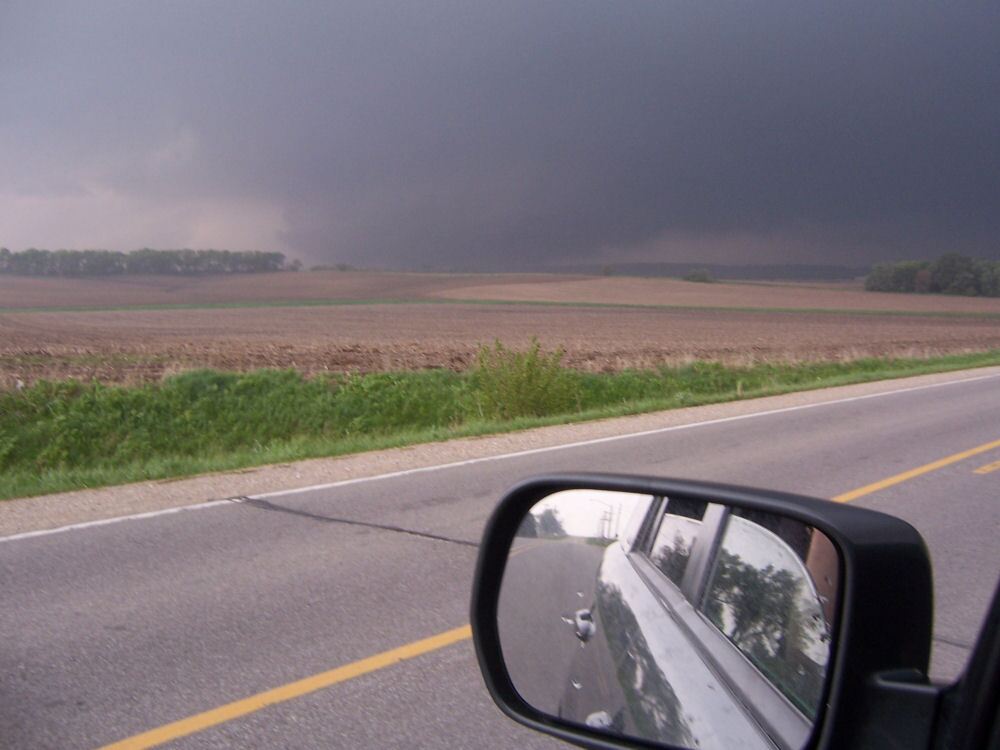
JUNE 11, 2008: LITTLE SIOUX SCOUT RANCH

Although the Millard tornadoes did not result in any loss of life, the tornado which hit Little Sioux IA just three days later unfortunately did. That afternoon, dozens of boy scouts were camping at the Little Sioux Scout Ranch in Monona County when a tornado hit. That tornado began on the Nebraska side of the river, east of Tekamah. Passing just north of Little Sioux, the tornado went into the Boy Scout Camp head on.
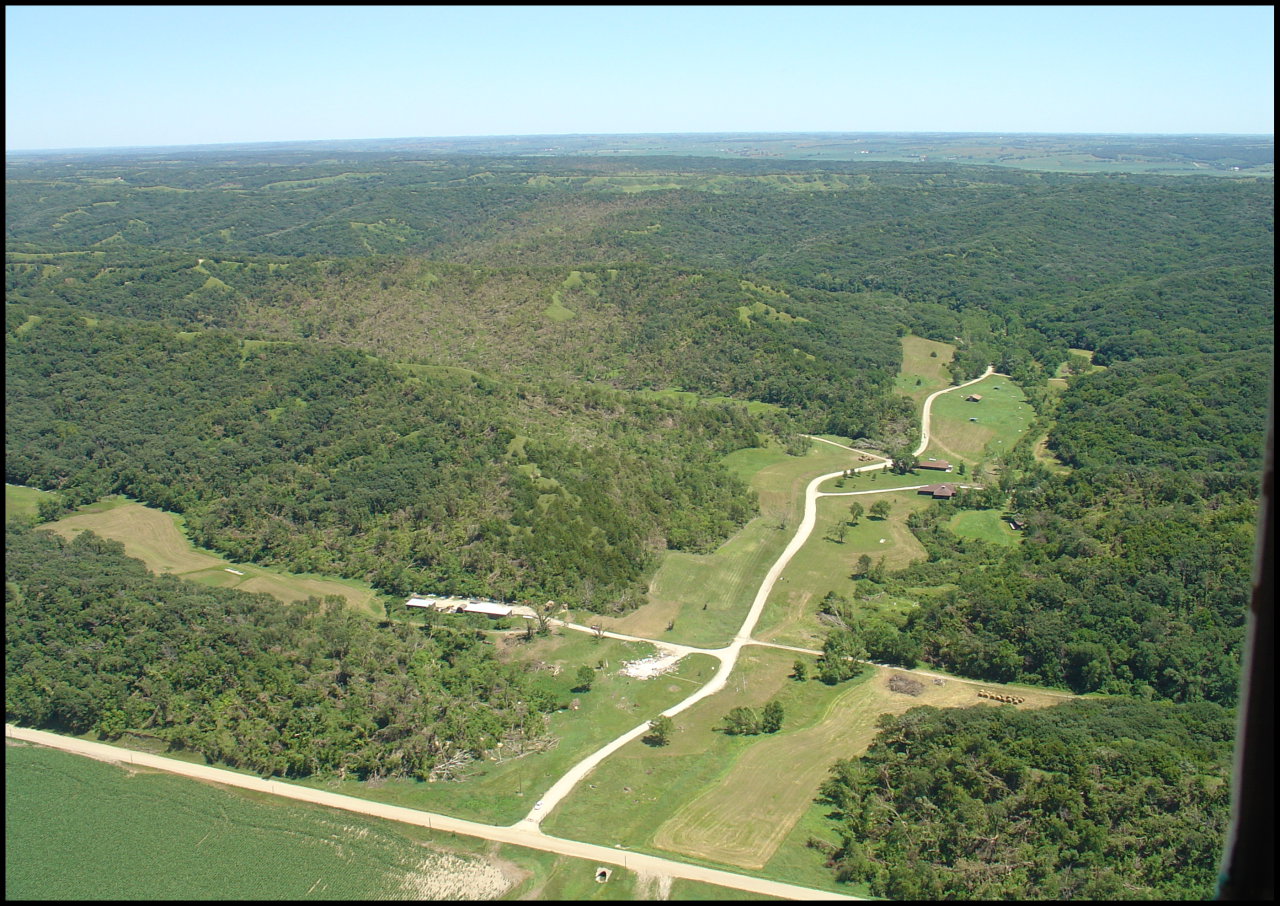
The boys took shelter as the tornado hit, the shelter was completely destroyed. Dozens of boys were injured in the tornado, but tragically four lost their lives when a chimney fell on them. Remembered today was the heroic actions taken by the boys, some of them injured, who assisted in recovery efforts. The motto and teachings of the Boy Scouts on full display. Today, a memorial sits at the Scout Ranch in remembrance of the four boys.

JUNE 27, 2008: MAJOR WINDSTORM HITS OMAHA
After the tragedy of June 11, severe weather in Nebraska and Iowa quieted down. However, the end of June would go out with a bang on June 27. That day, a severe storm produced winds upwards of 100-115mph through northern Saunders County into Douglas County. The winds did damage to homes south of Fremont, ripped apart a fireworks stand near Valley, and did major damage to two homes near 180th and Maple Streets. It was one of the most damaging storms in the Omaha metro area. 156,000 OPPD customers were without power, making this the 2nd largest power outage in Omaha history due to inclement weather. The #1 spot was the 100mph windstorm which moved through Omaha on July 10, 2021.
