
OMAHA, Neb. (KMTV) -- — Since the inception of the city, Omaha has grown physically by annexation. Beginning with its first pieces of land acquired in the 1850s, the city of Omaha has gradually grown either by establishing neighborhoods or by subsuming its neighboring communities into the city itself. In the 1910s, Omaha annexed three larger communities around it. In 1915 it moved to annex Dundee and South Omaha, although it took two extra years to fully annex Dundee after court battles. In 1917, Omaha annexed the towns of Florence and Benson. The city continued to expand westward through the establishment of neighborhoods. The next major annexation came in 1971 when Millard was brought into the fold.
On March 1, 2007, the final major expansion of Omaha occurred. Since 2005, the city of Omaha has been eyeing the community of Elkhorn along 204th St for official annexation. Since Elkhorn was a town with a population under 10,000 it was within Omaha's right to take the town. Elkhorn began an ambitious project of expansion to get over the 10,000 limit. After the Nebraska Supreme Court weighed in on the decision in favor of Omaha, Elkhorn was going to be annexed on March 1.
The day Elkhorn was being annexed, the entire region was smacked with the first blizzard of the 21st century. Within a day, up to 1' of snow fell alongside 50 mph winds. It shut down the region for a few days. In this installment of This Week in Weather History, we look at the first blizzard to ravage the Omaha region of the 21st century.
THE WEATHER SET-UP

As local headlines in Omaha focused on the coming annexation of Elkhorn, meteorologists watched a large storm system come ashore in the western United States on February 27. The storm system in question would have a lot of hallmarks of a typical major winter storm for Nebraska and Iowa. First, the storm was expected to have a lot of moisture with it as it would tap into a reservoir of moisture from the Gulf of Mexico. Second, the track of the storm system would bring it through Kansas and Missouri, the traditional path for major winter storms to pass on through. Finally, the storm was expected to strengthen, meaning the winds would become stronger rapidly. Due to the combination of factors, by February 27 meteorologists were calling for 4-8" of snow in Omaha. By the afternoon of the 28th, that had increased to up to 10" in the city, with higher amounts into western Iowa.
THE BLIZZARD
By the evening of February 28, a mass of rain and thunderstorms moved into Nebraska and Iowa. There was even a lone severe storm south of Beatrice that dropped penny size hail in Wymore, close to the Kansas border. Overnight, the rain changed over to heavy snow, and the snow fell over much of March 1. It ended by the evening but left havoc in its wake.

The snow began falling heavy just in time for the morning commute. Most schools had already canceled, but many businesses were open. Those who commuted found things rough as the heavy snow started falling around 6 am with amounts as high as 2" an hour. For some, a 20-minute commute lasted as long as 90 minutes, if they made it at all. By Mid-morning, I-80 was shut down from Omaha to Utica in Nebraska, and from Council Bluffs to east of Atlantic in Iowa.
Businesses began to stagger closings to not clog up the roads by mid-morning. At lunchtime, Omaha had been shut down. Those who were stranded sought shelter in buildings and homes as the blizzard continued. The snow ended by 4 pm, but the high winds up to 50 mph whipped up the snow to create whiteout conditions across much of the area.

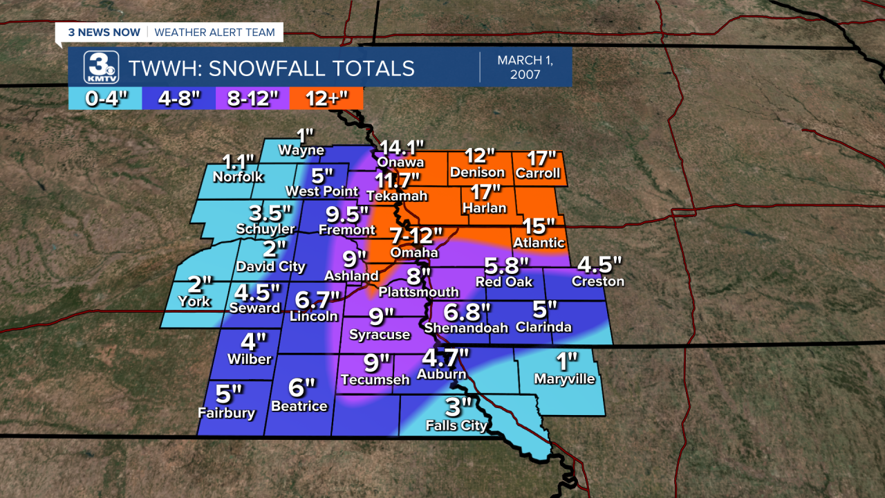
In terms of snowfall amounts, up to 12" fell in the western parts of the Omaha metro. The highest amounts were in Valley, Elkhorn, and Gretna. Lower totals fell from downtown to Bellevue, where only 6" of snow fell. In Lincoln, 6.6" of snow led to some power outages. The snowfall was much heavier over western Iowa, where cities like Carroll saw over 15" of snow!
The winds continued for days after the blizzard, making snow removal a nightmare as snow was being blown back onto the roads. Three days after the blizzard, motorists still struggled to get around in places outside the Omaha metro, as cities like Fremont were still cut off from the world. Even I-80 from Omaha to Lincoln was still impassable at times even two days after the snow stopped falling.
In Iowa, the blizzard was one of the worst experienced in the region in decades. Drifts up to 16 feet high in Carroll trapped people in their homes, unable to get out. Across Shelby and Cass Counties, it was some of the worst road conditions experienced since the 1970s, where 10-15 foot drifts piled high.
By the end of the weekend, March 5, conditions improved as the wind ended. Thankfully, no one was killed in Nebraska or Iowa. It is considered one of the worst blizzards of the 21st century so far, only rivaled by the Christmas Blizzard of 2009.

The blizzard continued northeast into Minnesota. In Duluth, it was one of the worst storms of the 21st century as drifts 20 feet high covered homes. The strong storm system also brought severe weather. Southwest of Kansas City, an F4 tornado hit the town of Blue Mound on the evening of February 28th. On March 1, a tornado outbreak swept through Alabama and Georgia with numerous strong to violent tornadoes. The deadliest occurred in Enterprise, AL where 8 were killed, 7 of them at the High School when a wall collapsed on a row of children. It was the first death inside schools due to a tornado since the 1990s.

The March 1 tornado outbreak and blizzard were truly historic in many aspects.
