


For Nebraska and Iowa, storm season usually runs from April through July, with many of our tornadoes occurring during May and June. March is sometimes not thought of as being a significant month for severe weather or tornadoes. However, they can be quite tornadic as last year showed us in Iowa. The deadliest tornado outbreak on record for Nebraska occurred on March 23, 1913. Needless to say, March can have its fair share of significant tornado activity.
This was aptly shown on March 13, 1990, when a powerful early-season tornado outbreak ripped through the central United States producing tornadoes from Texas to Illinois. The hardest hit states would be Oklahoma, Kansas, Nebraska, and Iowa. In this edition of This Week in Weather History, we look back at the tornado outbreak that ravaged central Nebraska into Iowa. As well as producing what is perhaps the longest tornado in Nebraska state history.
THE METEOROLOGY
The weather conditions on March 13, 1990, were about as perfect as they can be for severe weather in early March. Temperatures were unseasonably warm across much of the central US on the afternoon of March 12. Omaha hit a high temperature of 74 degrees, which ran nearly 30 degrees above the average high temperature of 47 degrees. With this warmth also brought a lot of humidity to the region, with dew points near 60 degrees, the threshold of severe weather for any time of year, let alone early March.
Overnight on March 12 into March 13, a cold front began moving eastward across Nebraska, stalling from Sioux City to Kearney. To the east, Omaha alongside much of eastern Nebraska woke up to temperatures in the 50s, while west of the front temperatures were in the 30s. This cold front would stall in that same corridor, acting as a warm front for much of the day.

To the south in Colorado, a low-pressure system was strengthening as it lifted northeast into northern Kansas on the morning of March 13. As it interacted with the warm humid air, a feature common in many Great Plains tornado outbreaks was established, the dryline. While we typically think of fronts as separating two airmasses of different temperatures (i.e., a cold front separates warm air and cold air), drylines separate airmasses of different humidities.

This dryline was set up from southern Nebraska through central Kansas into west Texas. Ahead of the dryline, temperatures were in the 60s with dewpoints in the 50s to low 60s, relative humidities were upwards of 80% or greater. Meanwhile, to the west of the dryline, temperatures were still in the 60s but dew points were in the 20s. This gave relative humidity numbers as less than 40%, very dry air. It would be this dryline that would be the focal point for significant thunderstorms to develop along it, the ingredients for a tornado outbreak were laid out.
THE NEBRASKA TORNADOES
By 4 pm, supercell thunderstorms began developing across central Nebraska and racing northeast. The tornado outbreak would be confined to central and eastern Nebraska, largely west of the Omaha metro. In total, 15 tornadoes touched down in Nebraska alone from the outbreak. One of them was an F-0, six of them were F-1, three of them were F-2, four of them were F-3, and one was an F-4. That F-4 would go on to be the longest-track tornado in Nebraska state history.

Minden/Gibbon/Shelton F-3

The first significant tornado to touch down in Nebraska on March 13 was south of Kearney near the town of Minden. This tornado moved northeast near the communities of Lowell, Gibbon, and Shelton. As the tornado moved through Kearney County, it damaged four farmsteads before crossing into Buffalo County where it destroyed a bridge crossing over the Platte. The tornado narrowly missed the towns of Gibbon and Shelton, damaging several outbuildings in the area. It lifted in western Hall County near Grand Island.
Grand Island F-3

Coming on the 10th anniversary of the "Night of the Twisters" in Grand Island, residents got another scare as an F-3 tornado narrowly missed the town to the west. This tornado touched down north of US-30, near the Husker Harvest Days location, and moved over the Army Ordinance Plant west of town, destroying 3 buildings. As it crossed the railroad tracks, it overturned 47 unoccupied train cars. As the tornado continued northeast, it was videoed by multiple people where you can see the multiple vortices swirl around the main tornado-like tendrils. As the tornado crossed into Howard County, it destroyed two unoccupied mobile homes. The tornado dissipated near Palmer in Merrick County after damaging a few more farmsteads.

WATCH the video of the Grand Island tornado here (WARNING: Some strong language)
Fillmore/Thayer County F-3's

This tornado touched down later at night in far northern Thayer County before moving into Fillmore County, missing the county seat of Geneva by a few miles. The tornado brushed the town of Strang where a mobile home was destroyed, and another building lost its roof. On another farm just to its northeast, a large hog facility was destroyed.
Another tornado impacted Thayer County around the same time as the one to the north. This tornado touched down just north of Chester and moved to the east of Hebron. Just northeast of Chester, two farm homes suffered damage as well as machinery taking extensive damage.
The F-2's and F-1's
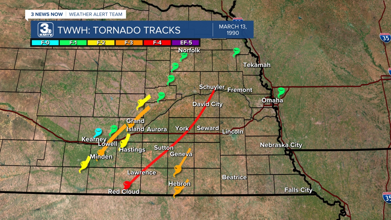
Many of the other tornadoes of the day were brief but still caused damage. Southwest of Minden, where the first F-3 tornado moved through, an F-2 damaged several farmsteads near Wilcox. Just west of Hastings, an F-2 moved over rural areas striking a few outbuildings, causing significant damage to one. A final F-2 moved through Nance County west of Fullerton, where several farmhouses were damaged.
F-1 tornadoes continued into Boone and Madison Counties, all of which were only on the ground for a few seconds and snapped trees or overturned irrigation pivots.
124 MILES: THE LONGEST TRACK TORNADO IN STATE HISTORY

By far the strongest tornado tore a path unheard of in Nebraska state history, traveling 124 miles from near Red Cloud by the Kansas border to Schuyler near the Platte River. If this path was continuous, and there is some disagreement on that, then it would constitute the longest-track tornado in Nebraska state history.
The tornado first touched down near Red Cloud, only a few miles north of the Kansas border. It immediately became large, as this video shows, with its peak width at a quarter mile wide. One farm was wiped out northeast of Red Cloud, and seven other farms were damaged in Webster County.

The tornado moved into northwestern Nuckolls County where it proceeded to slam the southeast side of Lawrence. Witnesses watched as the tornado, which was at first heading right for the town, made a sudden turn to the east sparing the center of town. Homes on the southeast side were not so lucky, as the tornado swept a few of them off their foundations. Three people were injured, but no one was killed as the tornado hit Lawrence.

The tornado soon moved into Clay County, missing the county seat of Clay Center by a few miles, but did hit the town of Sutton head-on. As the quarter-mile-wide tornado moved into Sutton, it damaged 1/3rd of the town, and over a dozen buildings. A small plane was tossed like a toy and destroyed, and one car dealership lost over 100 cars to the tornado. Four people were injured in Sutton, all of them in vehicles, one of them being a police officer who was watching the tornado.

The tornado then crossed into York County, where it destroyed a farm 4 miles west of McCool Junction. The tornado missed York to the south but did rip the roof off a motel at the I-80 interchange south of town. Two people were injured by flying glass. A gas station also sustained significant damage as the tornado passed through. Near Waco on the eastern side of the county, another train was derailed carrying coal, no one was injured in the incident.
Next up was Butler County, the tornado missed the town of Surprise but did sporadic damage as it barreled toward David City. Residents in the Butler County seat braced for impact, but right as the tornado moved into the southwest side of town it turned due north. This turn to the north spared the town from taking the brunt of the tornado, but residents near Octavia were hit by the tornado damaging property.
Finally, the tornado crossed the Platte River into Colfax County, where more farmsteads were damaged southeast of Schuyler. The 124-mile reign of terror finally ended 3 miles east of Schuyler when the tornado lifted. In total, the tornado killed no one and injured eight people, although it was estimated that 10,000 geese were killed in York County as the tornado passed through.
THE TORNADOES IN IOWA
Nebraska was far from the only location to experience significant weather on March 13, tornadoes also moved through Iowa as well. The storms came in waves through the state, wave 1 saw several tornadoes touch down near the Quad Cities in the far east end of the state.
Wave 2 was the most damaging, as several strong tornadoes moved through areas north of Des Moines. The costliest tornado hit the northern Des Moines suburb of Ankeny, where several homes were destroyed. Luckily, many people were not home and were attending a school function, likely sparing some lives. An F-3 tornado moved through the county north of Des Moines, where significant damage was done.
The third and final round of severe weather occurred with the Nebraska storms moving into western Iowa. In Little Sioux in Monona County, mobile homes had their roofs blown off. Damage was also done by high winds near Logan, and a tornado touched down near Underwood in Pottawattamie County.
THE HESSTON-GOESSEL, KS TORNADOES
The tornado outbreak of March 13, 1990, is remembered best for what occurred in central Kansas. An F-5 tornado, the highest magnitude tornado, tore through the small town of Hesston, KS north of Wichita. The damage was extensive, with homes swept off their foundation in a neighborhood on the north side of town. This tornado continued northeast until a second tornado touched down south of it, the two tornadoes merged, with the second tornado growing to become another F-5 tornado which passed near the town of Goessel. Ted Fujita, a man who spent his entire life studying tornadoes and created the F-scale we use to rate tornadoes, stated that he thought the Goessel tornado was one of the most intense to ever be recorded in the United States.

Overall, the tornado outbreak of March 13 produced 59 tornadoes, 15 of which occurred in Nebraska. It remains one of the most prolific tornado outbreaks in the central plains in recent memory.
