
Out of any month, March might be one of the wildest weather months for the Midwest. March has been known for some of the biggest blizzards and strongest tornado outbreaks in Nebraska and Iowa. It is the month where highs can reach 80 and lows go below 0, sometimes within the same week.
March 2006 characterized this well for the Midwest. In that month, Missouri saw a historic tornado outbreak on the 12th, Nebraska picked up 2 feet of snow on the 20th, and tornadoes struck the Omaha metro on the 30th. In this installment of This Week in Weather History, we look at the large snowstorm in March 2006 that brought upwards of 30" of snow to Nebraska.
THE WEATHER SET-UP
March 2006 was an active month for weather across the Midwest. From March 8-12, a major severe weather and tornado outbreak occurred over the central and southeast United States. The worst of the outbreak came on March 12, when over 50 tornadoes touched down across several states. The epicenter of this outbreak was focused in Missouri, where the majority of the strong tornadoes occurred. It remains the largest tornado outbreak in Missouri on record in terms of how many tornadoes occurred.

About a week after the tornado outbreak, another large storm system was moving into the central United States. Unlike the prior storm, this one would have some cold air to work with, meaning it would be a winter storm rather than a severe one. The main facet into what made this snowstorm so heavy for Nebraska was the slow-moving nature of the complex, it sat over the region for 3 straight days, dropping snow over much of the state.
Forecasts in the lead-up to the snowstorm were calling for hefty amounts west and south of Omaha. Due to dry air and borderline temperatures, snow amounts were expected to drop off rapidly over western Iowa. The main question was how much would it impact totals. Snowfall for Omaha were estimated in the 9-14" range according to the forecasts at the time.
THE SNOWSTORM
The snow began early on March 19, and would continue in waves for the next couple days. By 9am on the 19th, I-80 was closed near Seward due to multiple accidents. Events were cancelled, such as the "Rollin to Colon" charity bike ride to Colon in Saunders County. By the next morning, the warmer road temperatures kept them a slushy mess for the morning commute. While the commute was slow, many still were able to get to work. Most schools in eastern Nebraska canceled classes for both the 20th and the 21st, some even canceled well after the snow ended on the 22nd.
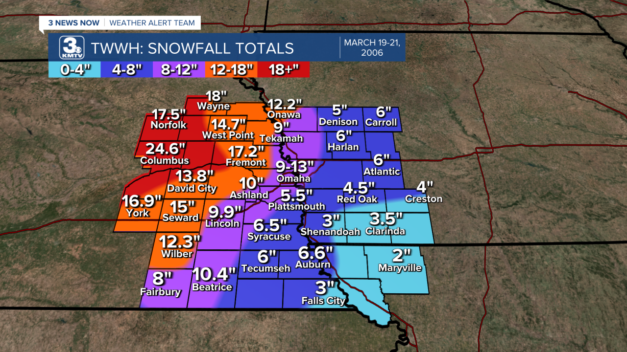
The dry air created a sharp difference in snowfall totals across the KMTV viewing area. Southeast of Omaha only saw a few inches, while those northwest of the metro picked up to 2' of snow! Since it was late March, the snow managed to melt quickly. Still it remains one of the biggest snowstorms to impact the area for March.
