
Since the first humans stepped foot in Nebraska, Iowa, and Missouri, flooding has always been a concern for those whose livelihoods were established along the various waterways of the region. Since documented records began, there has been historic flooding every 30-60 years along the Missouri River. The floods of 1881, 1952, 1993, and 2011 stand as some of the largest floods in the regions history.
As bad as those floods were, they hardly hold a candle against the floods that the Midwest experienced in March 2019. A rare combination of a cold and snowy winter, followed immediately by heavy rain led to a catastrophic chain reaction. For several days entire towns were evacuated, people were isolated, and unfathomable amounts of damage occurred that we still live with today. In the tales of tragedy also lay the undefeated goodwill of Nebraskans, Iowans, and Missourians as communities came together to bring out the best of a bad situation. In this installment of This Week in Weather History, let's go back 5 years to see the meteorological conditions that aligned to create the disaster, the sequence of events, and the response from the communities.
WINTER 2018-2019: THE CONDITIONS FOR DISASTER
The ingredients that came together for March 2019 were all silently building in the months preceding it. Winter began on October 14, 2018, when Omaha picked up 1.4" of snow, which was one of the earliest points in the season Omaha picked up over 1" of snow. November was cold but relatively dry, although 2.3" of snow did fall during the month. December and January were snowy, but temperatures hovered close to the average.
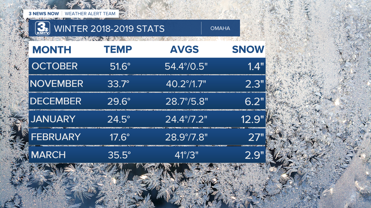
Then came February, when the already snowy winter got kicked up to an 11. For the entire month, 27" of snow fell in Omaha to make it the snowiest February on record and the 2nd snowiest month of any month, the record is 29.2" in March 1912 (more information here).

There were four periods of significant snow. The first came from February 4-7 with 1.9" of snow in Omaha, then came Feb 10-11 when 4.6" of snow fell. For 5 days straight between February 15-20, it snowed in Omaha to accumulate up to 13" of snow total!
Then came a blizzard. On February 23, a blizzard swept through Nebraska and Iowa dropping up to a foot of snow in some locations and bringing 45mph wind gusts with it. It was the largest snowstorm of the entire winter.

Likewise, as the snow continued to fall, it got cold. From mid-February into early March, temperatures hardly rose above freezing except for a couple of days. Between February 10 and March 10, the average temperature in Omaha was 17.2 degrees, the 3rd coldest Feb-Mar 10 on record. Not only did the cold temperatures not allow for a lot of snow melt, but it led to the continued freezing of river ice and the deepening layer of frozen ground as February gave way to March.
Early March continued the cold and snowy weather. On March 7, the last snowstorm of the season moved through the region. While Omaha only picked up 2" at Eppley Airfield, totals from Sarpy County westward were as high as 8" in spots.

By March 10, all the ingredients were in place. Snow depth measurements ranged from 3" in Omaha to 12" closer to Grand Island. Alongside the snow, the rivers were frozen solid. Ice thickness along the Platte River in the days before the floods was at 15" as measured by the Nebraska Emergency Management Agency (NEMA). The ground was also frozen solid too, the NWS in Valley measured 17" frost depth (meaning the ground was frozen 17" below the surface!), meaning that any rainfall would not absorb into the ground and would run off into the frozen rivers. The pieces were in place, and all that was needed was a bomb cyclone to light the fuse.

THE 'BOMB CYCLONE'
To many, the term "bomb cyclone" might sound like a made-up fear word that the media uses to describe big storms, like "polar vortex". However, the term "bomb cyclone", like "polar vortex", actually is meteorological. Bombogenesis is a term used to describe a low-pressure system that rapidly intensifies (deepens) 24 millibars (a measurement of pressure) within 24 hours. Typically, bomb cyclones are associated with storm systems in the Atlantic that can bring major blizzards to the northeast US. Rarely, they can form over the central United States. Bomb cyclones can bring with them major blizzards, heavy rain, severe weather, and powerful winds. This is what happened in March 2019.

By March 10, indications that a significant storm system that would bring heavy rain was becoming apparent. Flood Watches were being posted by the National Weather Service, and forecasts of several inches of rain were adding to the potential for significant flooding.
By March 12, the day before the cyclone, messaging was becoming more urgent. There was the potential for major to record crests along the rivers, and communities began to prepare. Sandbags were being deployed along the waterways, those who lived along the rivers began to evacuate, and emergency management agencies started to take precautions. Governor Pete Ricketts declared a State of Emergency for Nebraska. When the rain began on March 12, people were ready, but no one expected what was to come.

Rain fell periodically from March 12-13 as temperatures warmed into the 50s and 60s, rapidly melting the snow. Snow depths over central Nebraska fell as much as 8" in 24 hours. Across the KMTV viewing area, rainfall amounts ranged from 3/4" southwest of Omaha to over 2" in northeast NE, with Omaha receiving over 1" of rain.

Out in western Nebraska, the bomb cyclone brought a major blizzard that dropped up to 2' of snow near Chadron and other parts of the panhandle. The blizzard brought many communities to a halt, including multiple closures of I-80 due to accidents.

The final hazard from the cyclone was the high winds. Wind gusts both on March 13 and March 14 were frequently over 50 mph and occasionally gust over 60, the threshold for a severe thunderstorm warning. In western Nebraska, one recorded wind gust was over 80 mph. Besides being a nuisance, it caused accidents as high-profile vehicles were overturned, as well as causing some tree damage.
(The video above is a weather balloon launch from the National Weather Service in Rapid City, SD as wind gusts over 60 mph tried to rip the balloon from their hands)
THE FLOODS
The combination of all the factors above led to a week of significant flooding across parts of Nebraska and Iowa. Here is a region-by-region breakdown of what was experienced in March 2019.
Central Nebraska
Central Nebraska was one of the first regions to experience major flooding in March 2019, with the Loup and its associated tributaries causing major flooding. Some of the hardest-hit towns were around Grand Island. Wood River, Dannebrog, Gibbon, Pleasanton, St. Paul, and more suffered extensive flooding across the area. At some points, so many roads were closed that county EMAs ran out of barriers to cover the roads.
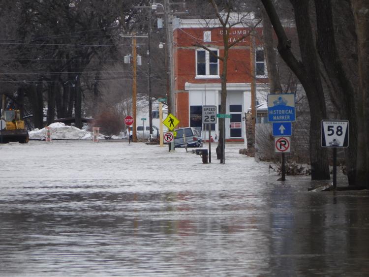

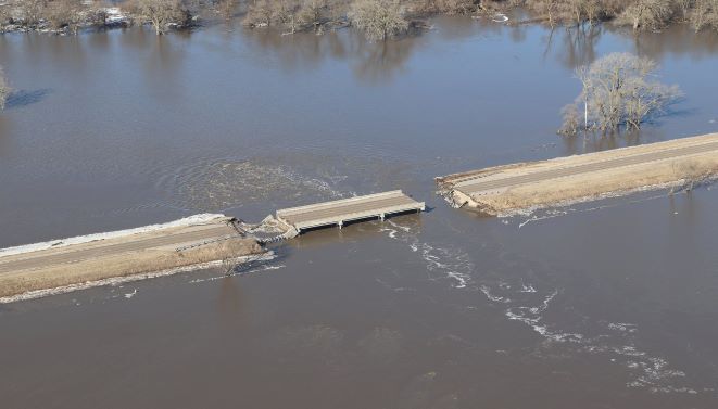
Near the mouth of the Loup River, cities such as Genoa and Saint Edward were also heavily flooded, with evacuations needing to take place in Genoa. Multiple bridges were washed away.
East/Northeast Nebraska
On March 13, the rivers rose as the water began covering the roads. Many highways were shut down by the afternoon, including US 275 in multiple spots. In Madison County, parts of Norfolk were evacuated when the Elkhorn threatened to flood, and several streets in town flooded. Tragically, one person in Norfolk drowned when a car was submerged in the flood waters and swept away the driver. Other roads were submerged in Stanton County.
Parts of Wisner were evacuated when flood waters rose close to the town, as were residences in Beemer in Cuming County. Three bridges over the Elkhorn in Cuming County were closed, and some parts of US 275 were under a foot of water. Wayne State College suffered some flooding at the Willow Bowl outdoor amphitheater. Other parts of Wayne, such as the airport and walking trails, were also underwater. Although a levee protected Pender from Logan Creek, some flooding did occur in the Community Center where water was as deep as 1.5 feet in spots. Flooding also submerged the city park in Craig, west of Tekamah. Maple Creek in Dodge County experienced water over its banks, causing major flooding in Nickerson where multiple homes were inundated by water. Winslow was also flooded out as the levee protecting it from the Elkhorn River was over topped. Flood gates on US 275 kept Scribner from becoming a victim of the flooding from Pebble Creek.

Shell Creek in Platte County experienced major flooding, inundating rural farms and sweeping away bridges. One man lost his life when he was driving his tractor over a bridge to rescue people trapped, but was swept away. Along the Loup River, areas around Monroe and Columbus were flooded, although the city of Columbus was mostly spared due to the levee. Another death occurred when a woman couldn't get medical aid due to flooding and died in her home. Further down the Platte River, areas south of Schuyler were flooded. A levee was over topped, flooding the town of Rogers which had to be evacuated.

Perhaps the most well-remembered event of the 2019 floods to those outside Nebraska and Iowa was what occurred to the Spencer Dam along the Niobrara River. in northern Nebraska. On March 14, the dam broke due to the pressure exerted by the rushing water and huge chunks of ice. This set an 11-foot wall of water along with huge chunks of ice downstream, shredding anything in its path. Bridges and buildings along the river were smashed and became debris as it washed downriver.


In and Around the Omaha Metro
Although northeast Nebraska was affected on Day 1, March 13. It took a couple more days for the effects of the flooding to move down the river. By March 15, extensive flooding occurred along the Platte and Elkhorn Rivers that impacted those along the waterways, namely near the county lines. The hardest hit communities were Fremont, Valley, Waterloo, Venice, Ashland, Louisville, Plattsmouth, and Bellevue.

For the most part, the core of Omaha proper was spared from any major flooding. The peak river crest on the Missouri River was 34.41 feet. For reference, a minor flood stage is a river crest of 29 ft, a moderate is 32 ft, and a major is 40 ft. It is the 3rd highest crest in the history of the recording site at Omaha, with the flood of April 1952 and Summer 2011 having higher crests.

In Fremont, at the height of the flood every main road in and out of town was flooded out, trapping Fremont from any road transportation. Isolated, a huge effort by many agencies to get aid into Fremont commenced. A convoy of planes flew from the Millard Airport to bring supplies to the town, as did trains (elevated a few feet higher). Although the main levees held most of the water back, many low-lying areas of Fremont were still flooded. An estimated 1500 homes and buildings were impacted by flooding, with 247 of them red-tagged. By March 17, roads slowly opened around town and aid managed to get in.

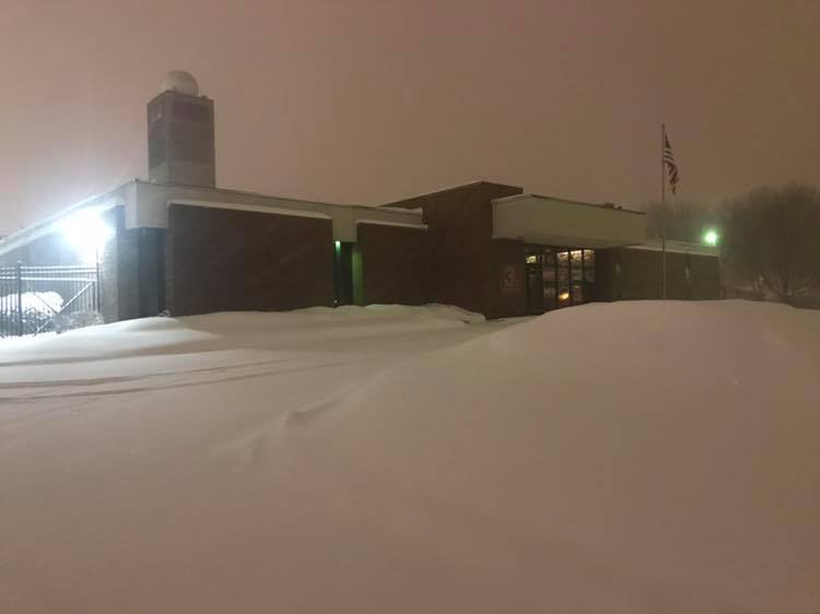
On the morning of March 15, the Union Dike between Fremont and Valley failed, sending water into Valley itself. Evacuations were ordered that morning, and much of the town fled before being inundated with water. The National Weather Service office is located in Valley, and they had to evacuate by 11 am that day. The NWS moved its services to Hastings. The office building in Valley was not flooded, but the water came within inches of the building. Meanwhile, the rest of Valley was flooded and the water did not recede until several days later.

The flooding continued down the Elkhorn River in western Douglas County. The Maple St, Dodge St, and Center St bridges that went over the Elkhorn all were impacted, with the Maple St bridge being completely washed away. Waterloo, thankfully, was spared much of the major flooding as the levee surrounding the town held. This was not the same for most of western Douglas County, as flooding impacted farms around the river site.
Along the Platte River, many riverside communities were flooded out and evacuated. Fremont Lakes, Woodcliff, Venice, and Linoma Beach, among others all suffered major flooding. Ashland, which sits atop a higher elevation, was spared much of the major flooding. However, levees were broken along the Platte outside of Ashland flooding much of the area near town. Camp Ashland, a National Guard facility, suffered extensive flooding which took several days to remedy.


In eastern Sarpy County, the Missouri River and the Platte River intersection caused major issues. A levee breach caused significant flooding at Offutt Air Force Base and surrounding neighborhoods in Bellevue. Offutt had to close for a couple of years due to the damage caused by the flooding. Most of Bellevue was spared, but neighborhoods close to the river were flooding. Flooding also impacted the Papillion Wastewater Management Plant.
Plattsmouth was also spared from significant flooding, although flood waters did impact the water treatment plant for the city. The communities of South Bend and Louisville were also impacted by the flooding.

Southeast Nebraska
Flooding impacted those even not close to the rivers, as many creeks and small rivers rose out of their banks and flooded certain communities. The Big Blue River near Seward rose out of its banks, flooding Highway 34 near town. In Crete, water from the Big Blue River flooded one home. Backed-up storm drains flooded many basements along Main Street and 20th Street in Crete too. The Big Blue River also closed Highway 136 in Gage County for a time and also flooded some streets in Wymore. In southern Saline County, Swan Creek flooded many roads across the area. The Little Blue River flooded several roads in Jefferson County too.

Most of the flooding that occurred in southeast Nebraska occurred along the Missouri River. Record crests along the Missouri River were hit at Nebraska City, Brownville, and Rulo. Homes were flooded along the river, particularly near Rulo. It took months for the Missouri River to finally recede in some parts of southeast Nebraska.
Western Iowa/Northwest MO
Like eastern Nebraska, western Iowa, and northwest Missouri also experienced major flooding along many of its rivers. The Soldier River in Monona County caused roads to be closed around Ute, although the town was mostly unaffected by any major flooding. In Mapleton, the Maple River brought significant flooding and damage to the local airport. The Crawford County fairgrounds were covered by water due to the Boyer River, and US 30 was closed between Denison and Dow City due to the floodwaters. US 71 was closed between 2nd St and US 30 in Carroll. In Harrison County, the Boyer River caused US 30 near Woodbine to close. A levee broke near Missouri Valley, causing residents to evacuate and some parts of town were flooded. Flooding of the Nishabotna River and Red Oak Creek also caused flooding around the city of Red Oak, and the west side of Coburg was underwater for a time.

Much of the significant flooding that occurred in Iowa was due to the Missouri River. Council Bluffs escaped much of the flooding, but some parts still had impacts. A mudslide closed Harry Langdon Blvd just north of I-80, and US 6 was closed in Pottawattamie County due to the Keg Creek. I-29 was closed from Council Bluffs to St. Joseph, MO for several weeks as some parts fell underwater. Many parts of I-29 were damaged, and they had to be rebuilt. Glenwood suffered minor flooding, with its water treatment plant flooded.
One of the hardest communities impacted in southwest Iowa was Pacific Junction, southwest of Glenwood in Mills County. On March 16, the levee protecting the town broke, flooding much of Pacific Junction. The flooding was catastrophic, the entire town was underwater, some as high as ceilings in some homes. The 200 homes in the town were reduced to 25, and about 3/4 of the town left. Buyout programs from the government were implemented, and the community is still rebuilding today.

The most widespread flooding occurred in Fremont County, where both the Missouri and Nishabotna Rivers experienced significant flooding. Multiple levee failures along the Missouri River flooded the communities of Bartlett, Percival, and Thurman. The hardest hit community was Hamburg, which was impacted by both the Missouri and Nishabotna Rivers. There was controversy surrounding the levee in the years before the floods, as many residents felt it was under prepared in case any flooding occurred, and funding was too short to strengthen it. Then the levee broke, and Hamburg was flooded. A fatality occurred near Hamburg when three people from Norfolk drove around a barrier and their car was swept away, one of them was killed, and the other two survived.
In northwest Missouri, the town of Craig in Holt County was flooded as a levee broke on the Missouri River. In Holt County alone, 30,000 acres of a total of 95,000 acres in the county were flooded as almost all levees were damaged in the county. The town of Corning was flooded as well. It took months for the flooding to completely recede, and some spots were still underwater by November 2019.
AFTERMATH
By the end of March, most of the floodwaters began to recede, but everyone's problems continued. #NebraskaStrong became a trending social media message as aid from across the country came to the state. Aerial tours by Pete Ricketts and others showed the world the true immensity of the damage, while Governor Kim Reynolds of Iowa did the same. In Nebraska alone, the floods of 2019 cost an estimated 1.9 billion dollars in damage, the costliest natural disaster in state history.
The impact it had on agriculture, infrastructure, and livelihoods is almost too much to be believed. Along the river, thousands of tons of sand and silt from the river sat in the fields preventing some farmers from planting crops. The removal of sand was a monumental effort on its own. Livestock were stranded due to the water, and many needed to be airlifted aid much like Operation Snowbound during the Winter of 1948-1949. In all, the impact on the agricultural center was enormous.
Infrastructure was equally widespread. At its peak, 3300 miles of roads were closed in Nebraska alone. 27 state highway bridges in the state were washed away, and needed to be replaced. I-29 in Iowa was closed for several weeks, one of the longest times an interstate has been closed due to weather in US history.
In total, the flooding of 2019 was one of the worst inland flood events in US history. Floodwaters stretched from the Dakotas to Illinois but had its epicenter over Nebraska. It is a disaster that many will soon not forget. Five years later, many communities have recovered and built up protections to prevent this from happening again. Levees were renewed, new ones were built, and more flood protections were put in place. We hope that another disaster of this magnitude will never happen again, but if the next one hits, the residents of Nebraska, Iowa, and Missouri will be better prepared.
