


Many families have traditions for Mother's Day, ranging from the common to the unusual. For many of these traditions, good weather is often a must. Yet, with Mother's Day in May, that can be a toss-up in Nebraska and Iowa. Case in point, in 2014, many families had to spend Mother's Day in basements as outdoor warning sirens blared.
On that afternoon, a single supercell storm went from Hastings to Omaha. This storm produced very large hail, strong winds, and over a dozen tornadoes. In this installment of This Week in Weather History, we look at the storm that produced multiple tornadoes over eastern Nebraska.
THE SET-UP
One storm, fourteen tornadoes. Of the roughly 100,000 thunderstorms in the US each year, only 1% produce tornadoes, let alone 14. So, what was the key ingredient for a storm to be so prolific in tornado production?
The answer was a warm front. Warm fronts, denoted on the weather map by a red line with semi-circles, separate warm air to the south and cold air to the north. Warm fronts often act as focal points for tornadoes due to the wind shift along them. South of the front, the wind is streaming northward, while north of the front, the winds shift to being out of the east. This turning of the wind, known as shear or helicity, is fodder for storms. If a severe storm can latch onto a warm front, it can produce tornadoes for hundreds of miles over several hours.
On May 11, 2014, a warm front was situated along eastern Nebraska from Hastings to Des Moines. The temperature contrast behind the front was strong: Falls City hit 87, while Norfolk was colder at 62. It was even colder over western Nebraska, where snow fell in the Panhandle!
THE COURSE OF THE STORM
The storm fired quickly south of Hastings along the triple point, a meteorological term describing the meeting point of the warm front, dry line, and low-pressure system. In this area, the lift to generate thunderstorms is maximized, and the storm explodes. At first, the storm was positioned just north of the warm front, meaning it was elevated and bringing in colder air. The storm produced 2" hail just south of Hastings and little tornado risk.
Yet, storms can transform from being elevated to being surface-based when a storm begins to get moisture from the surface. Surface-based storms are tornadic, as they suck in the warmer air. As the storm approached Clay Center, it suddenly latched onto the warm front and almost immediately became tornadic. For the next several hours, the storm would rapidly change between elevated and surface-based, making it an unpredictable beast as it rolled across the Nebraska plains.

The storm first produced a weak EF-0 southeast of Hastings, but as it passed south of Clay Center, it dropped its first big tornado. This tornado, rated EF-3 with winds up to 150 mph, tore across Clay County, bringing heavy damage to homes. One home was nearly destroyed west of Sutton. The tornado curved a path around Sutton proper, continuing to damage property. The tornado crossed into Fillmore County before lifting.

Though the tornado missed Sutton, the winds around the tornado were almost as intense. Winds up to 100 mph blasted Sutton, damaging the downtown area and snapping dozens of trees.

Across northern Fillmore County, the supercell would drop several more tornadoes. One was an EF-2, which hugged the Fillmore/York County line, damaging homes and power poles. To the southeast of this EF-2, a satellite tornado formed near Fairmont, producing EF-1 damage. This second tornado was rare as it was anti-cyclonic, which means it rotated clockwise. Only 1-2% of tornadoes are anti-cyclonic.

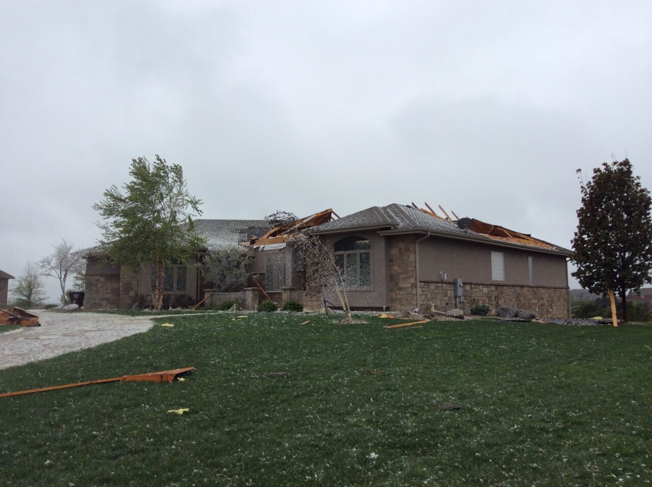
As the storm neared Seward County, it would drop the biggest and strongest tornado of its lifespan. An EF-3 tornado began north of Exeter. This tornado was huge, growing to be 1.5 miles wide at times as it crossed into Seward County. The tornado barely missed Cordova to the north before hitting Beaver Crossing head-on. Every home in town was damaged, with a few homes being destroyed. Miraculously, no one was injured or killed in Beaver Crossing. The tornado continued northeast before lifting near I-80, southwest of Seward.

Despite its strongest tornado having lifted, the storm was far from over as it continued through Seward County. A couple of miles to the east, an EF-2 tornado began and damaged several homes south of I-80. It crossed the interstate near the Hwy 15 interchange, throwing a semi truck onto its side. It lifted southeast of Seward. Throughout the storm's life, winds up to 100 mph were being thrust out of the storm to the south, resulting in extensive power pole damage across eastern Nebraska.

East of Seward, a second EF-2 tornado began and damaged more homes as it continued eastward. It lifted before crossing into Lancaster County.

Residents in Lincoln watched the black mass of the storm move to the north as it continued to produce tornado after tornado. An EF-1 went north of Malcolm. Near Raymond, an EF-1 and an EF-2 tornado had parallel tracks less than a mile apart.

The storm then crossed into Saunders County, dropping an EF-0 tornado east of Ceresco. More wind damage occurred between Ceresco and Ashland, grain bins were damaged. Nothing was stopping the storm, and it was heading right into the Omaha metro.

Sirens blared after 7 pm as the storm crossed the Platte River into Omaha. An EF-1 tornado began near Wann in Saunders County, then crossed into Douglas County. It continued into Skyline Ranches, where many homes had roof and tree damage. One home lost its entire second story in the neighborhood. Thankfully, no one in Skyline was injured or killed. This tornado lifted as it crossed 204th St just south of Dodge.

The storm had one final tornado, this time in Elkhorn. The tornado began north of Maple near 216th, not too far from the Ramblewood neighborhood, which was so heavily damaged from the EF-4 in April 2024. What is now developing neighborhoods was in 2014, mostly fields, as the tornado continued east. Damage was done to homes and trees around the Indian Creek Golf Club, Flanagan Lake, and Stone Creek Golf Course. The final tornado lifted just south of 156th and Ida Streets. The tornado reign of terror in eastern Nebraska was over.

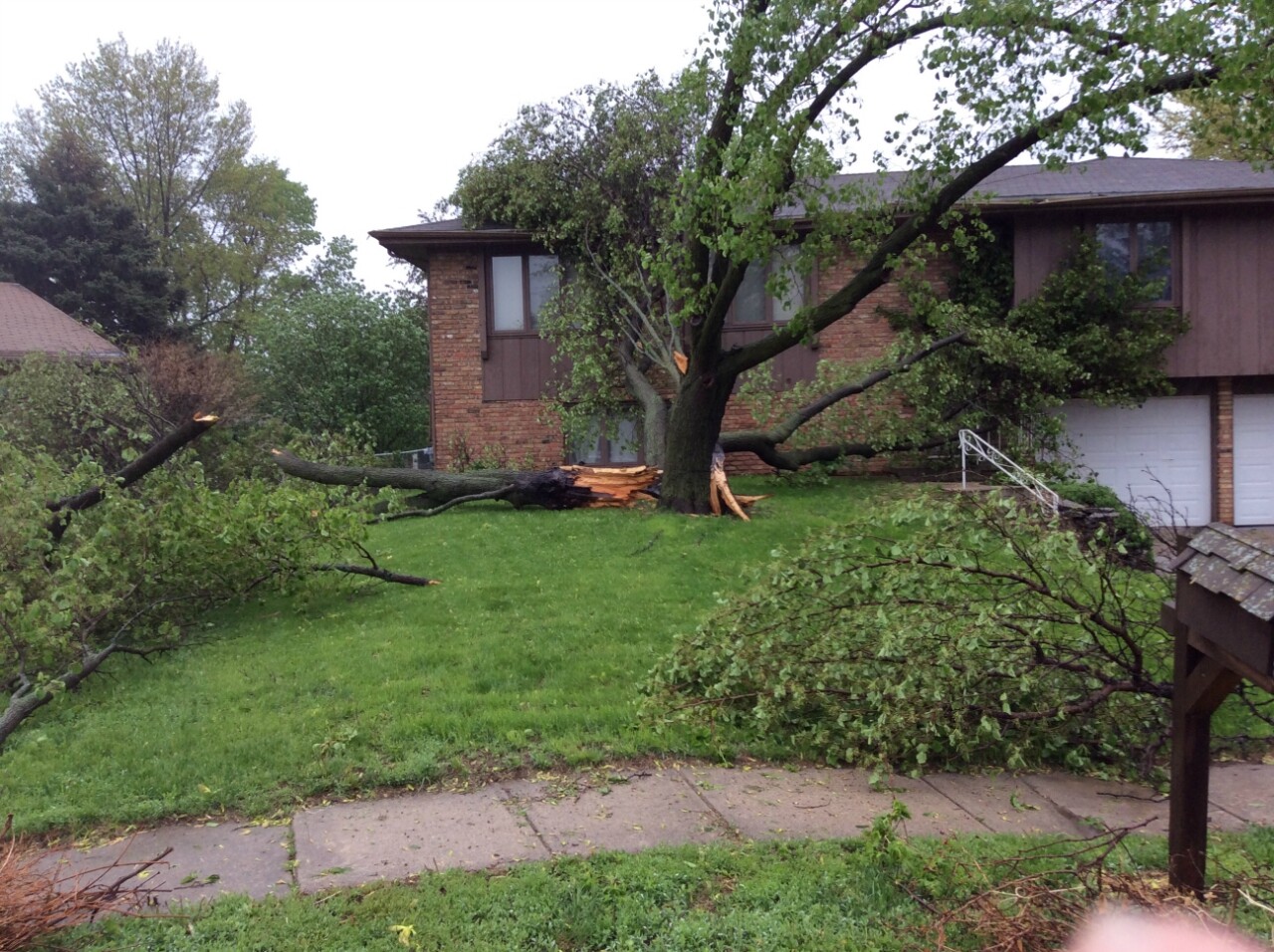
By this point, the storm was beginning to change character. It turned from a classic supercell to a messy cluster. The hail risk was turned down, but the high winds became commonplace. The Millard Airport recorded a 72 mph wind gust; other wind measurements from Elkhorn were up to the 70-80 mph range. Eppley Airfield recorded an 82 mph wind gust. Across the metro, scattered tree damage was apparent. One hard-hit neighborhood was around 52nd and Chicago, where several large trees were snapped.
As if the storms were not bad enough, they brought 1-3" of rain to the Omaha metro. Flooding on Saddle Creek & 115th and Pacific was bad, stalling many cars and closing some intersections.
Though the most intense storm by far, the Hastings to Omaha supercell was not the only storm to produce tornadoes on Mother's Day 2014. A separate storm developed on the heels of the first in Seward County and dropped an EF-1 tornado west of Beaver Crossing. This tornado almost impacted the same areas hit hard by the first tornado...30 minutes later.
To the south, a second supercell storm dropped an EF-1 tornado in Jefferson and Saline Counties. Damage was done in Swanton, where one home lost it's roof.

In total, Nebraska experienced 18 tornadoes on Mother's Day. The line of storms tracked into Iowa, where some damage was reported to trees. Near Des Moines, several weak tornadoes impacted homes northwest of the metro. Thankfully, no one was seriously injured or killed in the storms, but it certainly made for a memorable Mother's Day for those who lived through it.
