


Nov. 11, 1918, a jubilant Omaha crowd of 100,000 gathered around the Douglas County Courthouse in the evening and watched as a "body" went up in flames. The "body" being burned at the funeral pyre was no body, but the representation of the ex-Kaiser of Germany, Wilhelm II. Cries of "The Kaiser has gone to hell, long may he remain there!" echoed across the crowd. The "funeral" of Wilhelm II began at 8 p.m. on 10th and Farnam, heading up the street to the resting place at the courthouse.

The celebrations in Omaha were reflected across the country and the world, for Nov. 11, 1918, was a special day. At 11 a.m. on that day, the armistice that would end World War I went into effect as the guns fell silent across the Western Front. Ever since, Nov. 11 has been a day of both celebration and remembrance in the United States and Europe. In 1938, Nov. 11 would become an official holiday, Armistice Day. The day contained ceremonies such as the visitation of the Tomb of the Unknown Soldier. One year later, Armistice Day took on a whole other meaning as the world plunged into another war. After World War II, Armistice Day would become Veterans Day, to honor those who served in the later conflicts post-World War I.
Although parades and celebrations were held on Armistice Day 1940, the irony was not lost on anyone as the world burned in the Second World War. Between September 1939 and June 1940, Omaha citizens read in the papers as Nazi Germany took over Poland, Denmark, Norway, Luxembourg, the Netherlands, Belgium, and, most astonishingly, France. The United Kingdom was dealing with a relentless bombing campaign, the Blitz. In November 1940, attention was focused on the Mediterranean as Mussolini's Italy attacked British holdings in North Africa. On Oct. 29, a new European front opened up when the Italian forces invaded the Kingdom of Greece. In Asia, Japan was still engaged in a brutal war with China. The United States was neutral up to this point, but many Americans knew it was only a matter of time before their young boys would be sent off once more.

On Nov. 11, daily headlines in the papers of war ceased for a few days, and a new story much closer to home broke. As Europe, Asia, and Africa burned in the fires of war, the Midwest experienced another harrowing disaster of the natural kind. It was a blizzard, in fact, one of the blizzards remembered for generations, like the Schoolchildren's Blizzard of 1888. Known as the Armistice Day Blizzard of 1940, it brought the Midwest to a standstill as heavy snow, ice, brutal cold, and screaming winds ripped through the Midwest. In this installment of This Week in Weather History, we travel back to that dark time in history to look at the Armistice Day Blizzard of 1940.
THE WEATHER SET-UP
In the days leading up to Nov. 11, the fall of 1940 had been fairly warm. The high temperature in Omaha in October never fell below 60 degrees, with no freeze during the whole month. During the first few days of November, the highs remained in the 40s to 70s.
By Nov. 7, things began to change as a large storm system developed over the Pacific, west of the Washington Coast. The storm system battered the Pacific Northwest with winds of 40 mph. During these winds, the newly opened Tacoma Narrows Bridge in Washington began to sway. While bridges naturally sway some (if you stand on the Bob Kerrey Pedestrian Bridge during strong winds, you can feel the bridge sway a little), the Tacoma Narrows Bridge began to drastically sway from side to side, like waves on the Ocean, before it finally gave way and collapsed. Everybody managed to get off the bridge, but tragically, a frightened dog in a car did not survive. The Tacoma Narrows Bridge collapse is one of the most famous bridge collapses in U.S. history, and a foretaste of what this storm system was to bring to the rest of the U.S.
As the storm system moved across the Rocky Mountains on Nov. 8 and 9, the first major cold front of the season was sliding southward from Canada. Ahead of the front, temperatures remained in the 50s and 60s, but behind the front, temperatures fell into the teens and single digits. On Nov. 9, the cold front was positioned from Oregon to Minnesota. Along this temperature contrast, low-pressure systems can form, and that is what happened when the prior storm system emerged east of Colorado.

Low-pressure systems often strengthen, called cyclogenesis, once they leave the Rockies due to complex meteorological factors too much to explain here. Cyclogenesis along the tight temperature gradient allowed this storm to strengthen about as rapidly as any storm system can. On Nov. 10, this low-pressure system dropped pressure at a rapid rate over Oklahoma and Texas.

The final piece of the deadly puzzle was a strong high-pressure system over the Atlantic Ocean. This high pressure acted as a blocking system, now allowing the Oklahoma storm to move northeast. Thus, the low-pressure system took a sharp left hook northward over western Missouri into Iowa, then Wisconsin.

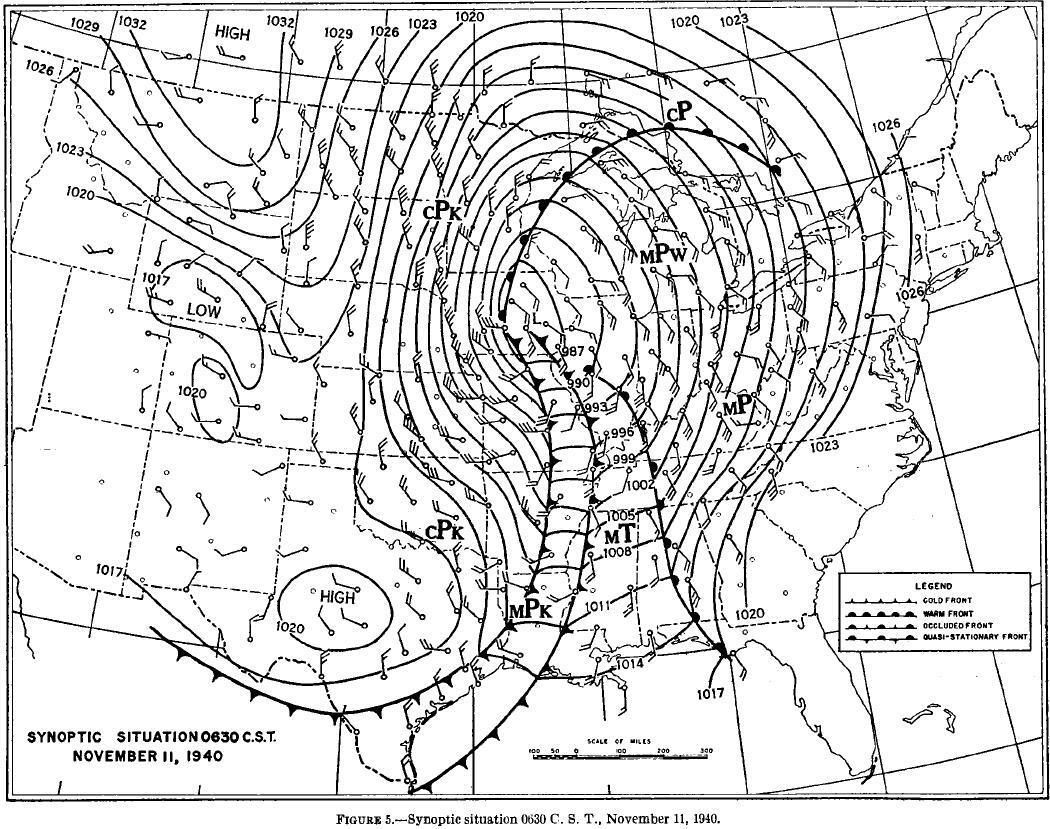
The central pressure of the storm deepened rapidly. At 7 p.m. on Nov. 10, the central pressure of the system was at 994 millibars (mb), which is standard for a typical low-pressure system. By 7 a.m. on Nov. 11, the pressure deepened to 983 mb; by 12 p.m., it was now at 973 mb; and by 7 p.m., it had dropped to an ear-popping 967 mb. To put this in perspective, that sort of low pressure is commonly seen in Category 2 hurricanes! The term for this strong lowering pressure is bombogenesis, which is defined as a pressure drop of 24 mb within 24 hours. Nebraska residents may remember this term from March 2019, as a similar scenario occurred with the low-pressure system, which was in part responsible for significant flooding across the state.

All of these factors came together on Nov. 11, 1940, to produce a fatal combination as a relatively unprepared Midwest was about to deal with one of the strongest blizzards in Midwest memory.
THE STORM IN NEBRASKA AND OMAHA
Fortunately, Nebraska missed the deadly factors of this storm system due to its timing. The sharp cold front had come through early in the evening on Nov. 10, meaning everyone was prepared for the snow when it began to fall. Snowfall amounts in eastern Nebraska and western Iowa were on the lower end for big blizzards, but enough to make an impact. In Omaha, Eppley Airfield recorded around 2" of snow, while other reports in the metro saw as much as 4-5". The higher snow totals were in northeast Nebraska into northern Iowa, where totals over 6" were common, and even a 10" report in McCool Junction south of York.

Throughout the day on Nov. 11, Omaha was subjected to brutal cold and high wind. The temperature at 8 a.m. was 15 degrees, and stayed in the teens much of the day. As winds blew 40-50 mph, wind chill values were below zero. Whiteout conditions were reported across much of eastern Nebraska, snarling traffic and halting trains. The strong winds also downed telephone lines, leaving power out in several areas across Omaha and Lincoln.

One significant effect the storm had in Nebraska was on trees. As the temperatures were relatively warm, no freeze stopped the growing season. A few days before the blizzard, over 1" of rain fell on top of a long drought Nebraska had seen. The moisture-starved trees absorbed the water, only to have it all turned to ice when the cold front came through on Nov. 10. Known as "frost crack", many trees were shattered by the growing ice. This put a major dent in Nebraska's apple industry, and many farmers switched from apple growing to soybean production.
THE BLIZZARD ACROSS THE MIDWEST
8 a.m., Nov. 11. Temperatures across much of the eastern Midwest were in the 50s, a rarity for that time of year. Excited about the day, many duck hunters took to the rivers and waterways to begin hunting. Since it was a holiday, many had the day off work or school, so they spent their day on the water. Many marveled at the number of ducks that were flying south that day. In light jackets and short sleeves, no one stopped to ponder why there were so many ducks fleeing south. The ducks knew what the hunters did not, that the weather was about to change, fast.

Weather forecasting in 1940 was nowhere near as advanced as today. The Weather Bureau, the precursor to the National Weather Service, took daily observations and wrote general forecasts. There were no satellites, no radar, little upper-air observations, and no computer forecasting models. Thus, Weather Bureau officials failed to recognize the strengthening aspect of the storm and gave little to no warning to those across the Midwest.

Similar to how schoolchildren were caught from a sunny, comfortable day to a ferocious blizzard in minutes back in 1888, duck hunters experienced the same thing in 1940. Across Iowa, Minnesota, Wisconsin, and Illinois, once the cold front blew through, the temperatures plummeted. In some spots, the temperature dropped ten degrees in a matter of minutes, and almost 30 degrees within a couple of hours. Once the temperatures fell, so too did the snow; at times it was heavy. As the snow fell, the wind blew at times over 60 mph, enough to do tree damage in some spots. In western Michigan, wind gusts topped 80 mph.

The next few hours for duck hunters were out of a horror movie. Many on boats were buffeted by waves several feet high, driven by the unrelenting wind. As the snow fell, visibility dropped to around 30 feet. Several got lost trying to find their way to shore. Some got lucky and managed to land on an island or the shoreline, but could not brave the whiteout conditions to find more adequate shelter. Those who could turned their boats upside down to shelter from the storm, others clung onto trees or brush, while a few hid in hay bales. When it was over, rescue efforts began as people rushed through the deep snow. Some made it, others did not. Many hunters suffered frostbite, and a few needed limbs amputated. While exact figures of the death toll of the duck hunters will probably never be known, it was in the dozens, even as high as 70 people across the Midwest.
The story of the duck hunters was the most tragic element of the blizzard, as the fact that it was a holiday where people had work/school off sealed many fates. However, it was also a blessing for those not caught outdoors. Since many were off work or school, residents in the Midwest rode out the storm in their homes.

As the storm system continued northeast, the second great tragedy occurred on the Great Lakes. Large ships were caught in the 70+ mph winds that threw the ships across the choppy waters. Three major ships, the SS Anna C. Minch, the SS Novadac, and the SS William B. Davock were all sunk in the storm. In the Anna B. Minch, the boat broke in two and sank, taking the lives of all 24 people on board. The Novadac hugged the eastern shoreline of Michigan due to the southeast winds in the morning, but when the winds suddenly shifted to the northwest at 70 mph, it threw the ship into the sandbars offshore. All but two on the Novadac survived. The William B. Dovack suffered the same fate as the Anna S. Minch when it sank during the storm, killing all 32 people.

In total, 66 people died on the lakes that day, combined with the dozens across the Midwest, putting the death toll for the Armistice Day Blizzard at over 140.
AFTERMATH
As the storm system moved away, it left damage in its wake. Across Minnesota, snow up to 2' buried many locations, and snow drifts were as high as 6'. It temporarily halted transportation services. Armistice Day celebrations were canceled and moved to later dates.
The temperatures after the blizzard remained one of the coldest November cold snaps seen in Omaha, as highs barely hit the 20s for several days. However, by Nov. 17, it was back into the 50s and 60s, and any snow left melted pretty quickly.
On Dec. 7, 1941, the war that so many dreaded would come to the United States when Japan bombed Pearl Harbor. Many of the same men and boys who were duck hunting on Nov. 11 went off to the jungles of the Pacific, the deserts of North Africa, or the rolling hills of western Europe in the final years of World War II. Despite the brutal conditions of wartime and the terrain, some came home with their worst day not in the Second World War, but from the blizzard of 1940.
In the days following the blizzard, public outcry at the weather forecasts was aimed at the Weather Bureau and its structural deficiencies. For starters, forecasts for the entire Midwest were exclusively out of Chicago, which was only staffed for 15-18 hours a day. Since there was no one in the office in the morning, they did not record the rapidly deepening storm system to give adequate warnings. The Weather Bureau listened to the outcry and changed its ways. Another Weather Bureau location was opened in Minneapolis to narrow down the geographic region for forecasting, and offices were staffed 24/7. These changes began the effects that would lead to the modern weather service with its over 100 offices staffed 24/7 to provide up-to-the-minute weather information.
Another long-term impact was on the agricultural industry in the Midwest. Before 1940, Nebraska and particularly Iowa were big in the apple industry, as orchards spanned both states. Then the blizzard came, which destroyed many apple trees across both states. Due to increasing food demands in the war, and the fact that it would take years to re-grow apple trees, many farmers adapted to grow different crops. This was the beginning of the major corn and soybean booms seen in both states. It was in the frost-bitten fields of the blizzard of 1940 that the "Corn Belt" became what it is today.
SOURCES/FURTHER READING
A full report on the meteorology of the blizzard of 1940 can be read here from the Monthly Weather Review.
For more information on the Duck Hunters, an article in Ducks Unlimited focuses on the experience of the hunters, including several harrowing accounts.
For more general information on the storm and its impacts, the National Weather Service offices in Davenport, Iowa and La Crosse, Wis. has information.
