


Since 2000, Nebraska has experienced a total of 8 violent (EF-4) tornadoes. These are The Hallam Tornado (May 22, 2004); the Coleridge Tornado (June 22, 2003); the Wayne Tornado (October 4, 2013); and the four Stanton-Pilger-Wisner-Wakefield Tornadoes (June 16, 2014). Of these 8, the tornado which was the most unusual was the one that hit Wayne Nebraska in October 2013.
From a historic blizzard in the panhandle, flooding in the Platte, and violent tornadoes in northeast NE, the weather system in early October 2013 was certainly one for the record books. In this installment of This Week in Weather History, let's go back 10 years to northeast NE and look at one of the most substantial fall tornado outbreaks in recent Nebraska and Iowa history.
A QUICK HISTORY OF WAYNE
Standing tall above the rest of the town is the light blue water tower. Printed on that tower is "Wayne America", the unofficial official nickname of the town. The origin of the nickname came from the Vietnam era, and it stuck. In the early 1980s, the water tower printed the nickname on it. Nowadays, residents and visitors alike use the nickname to refer to the community pride.

That community has its origins in the 19th century. Settlers began to plot land in the future Wayne as early as 1869, but once a railroad was built connecting Norfolk to Sioux City more settlers joined in. Originally called Brookdale, settlers eventually changed the name to Wayne after the Revolutionary War hero General "Mad" Anthony Wayne. Wayne was incorporated in 1884.

In the 1890s, community members in Wayne banded around a math professor James Pile to found the Nebraska Normal College. In 1909, the state of Nebraska purchased the college. After having its name changed to "State Normal School and Teachers College" and then to "Nebraska State Teachers College at Wayne", in 1963 the school shortened its name to the current "Wayne State College". Now, Wayne State College is known for its academic reputation and the success of its graduates, with a school population of just over 3,000 as of the 2020-2021 school year.

In 2020, Wayne had a population of 5,973 people. Driving north on Highway 15 you hit the historic business district, located in the south-central part of the town. Wayne State College is on the north side of town. To the east lies the industrial park on the far east side of Wayne, with softball fields to the southwest of the industrial park. Just east of the industrial park is Wayne Municipal Airport, where the Wayne America Fly-in competition was hosted earlier this year.

THE WEATHER SET-UP
The weather for late September into early October 2013 was active. Through mid-September 2013, a series of heavy rain events in eastern Colorado brought significant flooding to the area. That water flowed into the Platte River and moved into Nebraska, for the last few weeks of September towns along the Platte in Nebraska braced for flooding. These floodwaters began to recede into early October, but attention would swing to the next big storm system from October 3 into the 4th.
A warm front sat across southern Nebraska on October 3, sparking storms during the late evening. This low-pressure system deepened from northern Kansas into Nebraska on the 4th. Ahead of the cold front sweeping across Nebraska, warm air into the 80s moved as far north as Omaha, and moisture accompanied it. Ample wind shear associated with the system meant the atmosphere was prime for severe weather and tornadoes across northeast NE into northwest IA.

On the cold side of the low-pressure system, a blizzard of truly historic proportions crippled the panhandle of Nebraska. Near Chadron, over 2' of snow accompanied by wind gusts over 50mph brought the region to a standstill. Western South Dakota saw one of the worst blizzards in its history. Known as the "Cattlemans Blizzard" for the amount of cattle stuck outdoors and died, the blizzard crippled the region for days.
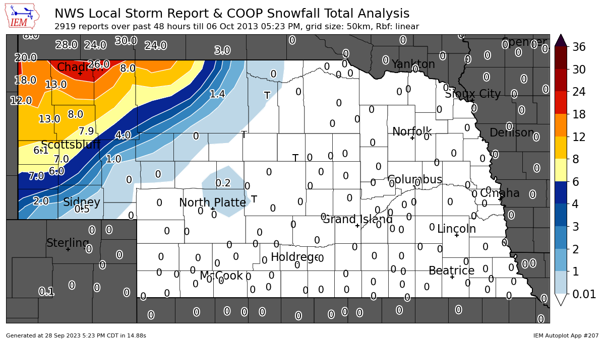
The blizzard/tornado outbreak occurred in the midst of the 2013 Government Shutdown, which delayed federal aid to South Dakota and Nebraska.

PRELUDE: OCTOBER 3 TORNADOES
It was uncertain if storms would develop over southeast Nebraska on October 3. The problem was a cap, a layer of warm, dry air that acts as a lid preventing thunderstorm development. The cap held through most of the day, but it gave way towards sunset. An isolated supercell developed over Saline County, dropping hail up to baseball size near Wilber. The storm slowly moved northeastward into Lancaster County, staying south of Lincoln. By the time the supercell died in Cass County, it produced 2 tornadoes, one of which would be rated an EF-2.

The EF-2 tornado touched down southwest of Hickman in Lancaster County. The tornado did its worst damage at the Wagon Train Lake Recreation Area, where homes were severely damaged and trees snapped. The tornado barely moved south of Bennet before crossing into Otoe County. The tornado lifted just north of Palmyra. A second EF-0 tornado touched down in southern Cass County south of Elmwood.
OVERVIEW: OCTOBER 4 TORNADOES

The tornado outbreak of October 4 was fairly localized, with all of the tornadoes occurring within a 50-mile radius of Sioux City, although the town would get lucky as the tornadoes missed the town. 17 tornadoes were confirmed on October 4: seven were EF-0, five were EF-1, two were EF-2, one was EF-3, and two were EF-4. One of those two EF-4 tornadoes moved through Wayne, another just east of Sioux City.
An EF-2 tornado moved just east of the town of Royal in Antelope County, west of Norfolk. Several farmsteads were destroyed, and outbuildings leveled.
Further north in Knox County, northwest of Norfolk, an EF-3 tornado passed just east of Creighton (the town, not the university). The tornado hit the Creighton Municipal Airport where several hangers holding planes were destroyed.

More tornadoes touched down northwest of Sioux City near the NE/IA/SD triple point, these tornadoes were rated EF-1 and produced minor damage in that area.
East of Sioux City, an EF-4 tornado moved near the town of Moville in Woodbury County. Homes were destroyed and shifted off of their foundations. A large grain cart was dragged across the road, putting deep gouges in the cement road nearby.
The other violent tornado threatened Wayne itself, while another tornado struck Macy in Thurston County.
THE WAYNE TORNADO

Before dropping the Wayne EF-4, a weak EF-0 tornado tore up cornfields southwest of Stanton. This tornado was filmed by storm chasers before lifting.

The Wayne tornado touched down about 8 miles south-southwest of Wayne, originally doing minor damage to corn crops and outbuildings in southern Wayne County. As quickly as the tornado touched down it widened to over a mile wide as it approached Nebraska Highway 15. The maximum width of the Wayne tornado was 1.38 miles wide, making it one of the widest tornadoes in recent Nebraska history outside of the Hallam tornado.

The tornado directly impacted a farm on 851st St., causing significant damage to the buildings. More homes were damaged west of Highway 15 as the tornado continued to the northeast. Photographs and videos from storm chasers of the wide tornado showed a wispy line of mist ahead of the tornado which represented the strong winds blowing ahead of the tornado. Chasers dubbed this mist the "ghost train" just adding to the creepiness factor.

The tornado crossed Highway 15 and took aim at two farms on the east side of the road. Those homes were nearly wiped off of their foundation, and most of the walls were gone exposing much of the floorplan. The damage was rated EF-3 with windspeeds between 136 and 165 mph.

The tornado moved over mostly fields as it approached the eastern side of Wayne. The town itself got incredibly lucky, for if the tornado was just a mile to the west it would have gone through the heart of town. Still, the tornado clipped the eastern side of Wayne and caused significant damage.


The first structure to be impacted in Wayne was the Summer Sports Complex on the southeast side of town, in particular the softball fields. The large stand in the center collapsed, sending debris sprawling across the complex. A trailer on the north side of the complex was rolled 220 feet to the south. Despite the significant damage to the softball fields, it was only sideswiped by the tornado as it crossed Centennial Road.


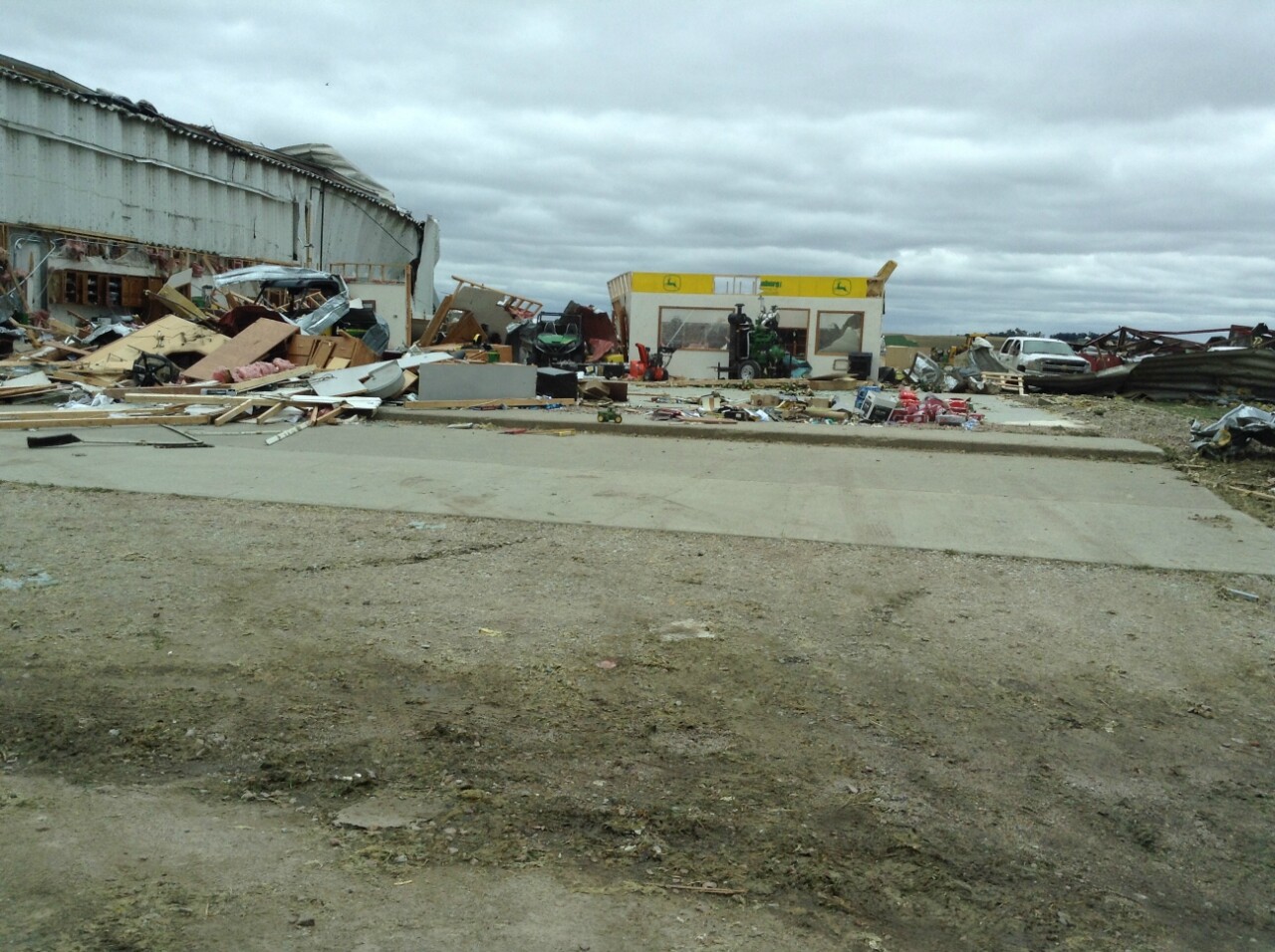
East of the street is the Wayne Business Park, an industrial center that has its origins in the 1960s, and the location which bore the brunt of the tornado. The industrial park was filled with warehouses and heavy machinery as many machine manufacturers called the industrial park home. Many of the large warehouses were shredded almost to an unrecognizable quality, the worst damage being to the building belonging to NMC - Nebraska Machinery where the whole metal building was crumpled into a piece of paper, indicating winds of 170mph.


The Grossenberg Implement, a John Deere manufacturer, was located on the east side of the industrial park. Most of the showroom building was wiped away, and the farm machinery was also damaged. A few of the lighter pieces of machinery were tossed into Highway 35.

The tornado crossed Highway 35, where a remarkable story of survival occurred. John Dunning, the Chief Information Officer of Wayne State College, was driving westbound on Highway 35 with a colleague when the tornado approached them. The tornado caught the two near the Industrial Park throwing debris at them. John drove the car into a drainage ditch between a creek and Industrial Drive. His colleague managed to get out of the car and into the ditch, but John struggled with the seat belt which cost him a few seconds. He barely made it out of the car before debris dragged him away into the field. He was pelted with debris, including having a dumpster land on him, before the tornado passed. John suffered extensive injuries and was close to death, but miraculously he was still alive. After being in a medically induced coma for 12 days and having 36 surgeries, he made a full recovery.
As the tornado crossed Highway 35 during John's ordeal, it hit the buildings across the street. The storage facility at Wayne Mini-Storage was partially shredded. Further northeast, the Pacific Coast Feather Company was a mattress factory which was on Industrial Dr. The factory was completely destroyed, it is the only building in Wayne not to be rebuilt after the tornado, and an empty lot exists there today.


Across the creek sat the Wayne Municipal Airport, which took a direct hit from the tornado. Two airplane hangers were destroyed tossing planes and crumpling them like toys. 15 planes were lost at the airport. It continued up the runways and shredded the Automated Weather Observing System (AWOS) which sat at the center of the airport. The airport was knocked out of commission for a while.


On the same lot as the airport sits a home where a new couple moved in 2 weeks prior. The home was completely wiped away, leaving only the cement bricks of the basement remaining. The couple were in the basement and survived the tornado, but the home was gone.

After ripping through the airport, the tornado heavily damaged a farmstead on the northeast side of the airport. It continued further northeast through the rest of Wayne County before crossing into Dixon County where it steadily weakened and lifted. The tornado traveled over 18 miles. No one was killed in the monster tornado, but 15 people were injured.
VIDEOS OF THE TORNADO (links to YouTube, some may have strong language): Adam Lucio, Skip Talbot, Brandon Sullivan
Today, much of the city that was hit recovered. The airport was rebuilt, as well as the industrial center. Many in Wayne still count their lucky stars the tornado veered east away from the heart of town, as the story could have been much different.
THE MACY TORNADO

30 minutes after the Wayne Tornado, a second supercell developed over Burt County. This storm crossed into eastern Thurston County and put down an EF-2 tornado just a few miles southwest of the village of Macy. With a population of just over 1,000 as of 2020, Macy is the headquarters of the Omaha Indian tribe as well as the Omaha Nation Public Schools.
The tornado moved through the eastern side of Macy, missing the Tribal Building and the Public school by a few hundred yards. Several homes on the south side of Macy were significantly damaged, 6 of them being uninhabitable after the tornado hit.


It crossed over a field which today is a BMX park and trail, snapping trees. Then it crossed over the parking lot for the Head Start School, it snapped light poles and threw cars around. It hit two more homes doing damage before crossing out of Macy and moved over US 75.


The tornado crossed the river shortly thereafter into Monona County where it snapped power poles, then into Woodbury County where trees and homes were damaged. The same supercell that produced the Macy tornado would go on to produce the other EF-4 near Moville.
VIDEO OF THE TORNADO: Tony Laubach
