Winter storms in Nebraska and Iowa come with the territory in winter, but blizzards are rarer. Since 2000, the National Weather Service Office in Omaha issued less than 20 Blizzard Warnings. This means eastern Nebraska experiences roughly 1 blizzard every year or so. In Omaha, there have been 7 Blizzard Warnings issued by the NWS office, meaning Omaha experiences a blizzard around once every three years.
For a winter storm to be classified as a blizzard, it has NOTHING to do with snowfall totals, contrary to popular belief. For a winter storm to be a blizzard, winds must be at or above 35mph or greater, reducing visibilities to less than 1/4 mile, for at least 3 hours. Sometimes blizzard warnings could be issued for blowing snow, after the storm has moved through.
However, blizzards can and often do create significant snowfall amounts, as the Groundhog Day Blizzard of 2016 saw in central parts of the state. In jusr 48 hours, some locations in Nebraska picked up over 1' of snow in some locations, bringing the region to a standstill for several days. In this installment of This Week in Weather History, let's recap the Groundhog Day Blizzard of 2016.
THE STORM
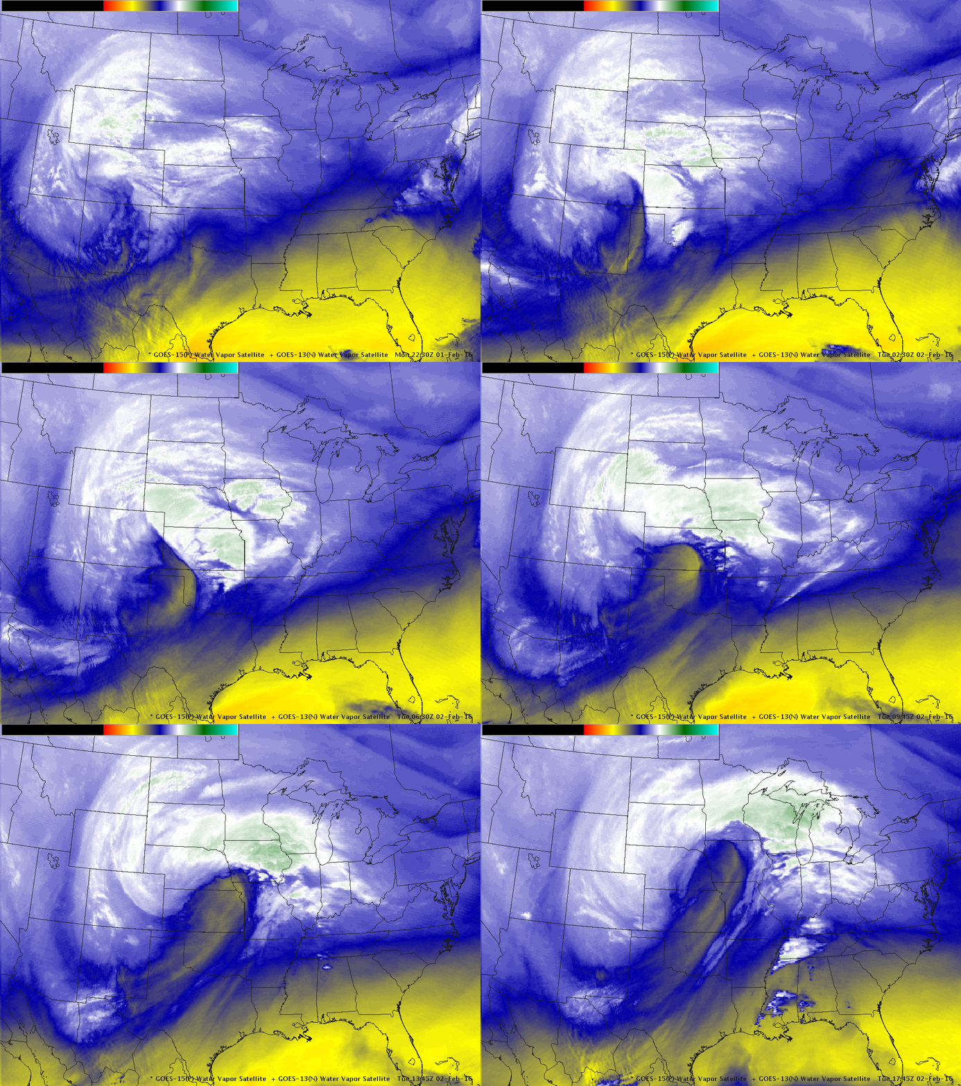
Like many of our largest snowstorms, the low-pressure system originated out of Colorado, often the favored storm track for significant snow in our region. You can read all about that here. This low pressure moved slowly through Kansas, then into southeast Nebraska, eventually up into Iowa where it occluded. The storm was strong, sucking in both warm air from the Gulf and cold air from Canada. As the moisture from the Gulf overlaid the cold air from Canada, it set up the perfect scenario for heavy snowfall across much of eastern Nebraska into western Iowa.

Heavy snowfall began in the Omaha metro early on February 2, where snowfall rates up to 1-2" per hour led to the snow quickly accumulating. However, parts of the Omaha metro and points southeast had their snowfall brought to an end with the "snow killer", the dry slot.

For many across central NE, the Groundhog Day Blizzard of 2016 will be one not soon forgotten. For one man, it was life or death. After being on the list for a heart transplant, Dan Griffen got the call in the middle of the blizzard in his central NE town that his surgery would be the next day in Omaha. Problem was, I-80 was closed from Grand Island to Omaha, meaning it was impossible for him to get to his surgery. That's when Nebraska stepped in to get him to the city. First, a fire truck took him from his home, then a snowplow took him to Grand Island, where an ambulance took him on the closed interstate to get to Omaha. He made it on time and was able to get his life-saving heart surgery. View the story as it happened here.
WHAT IS THE "DRY SLOT"?
A low-pressure system acts as a vacuum in the atmosphere that airmasses around it want to fill. Thus, it pulls both warm, moist air from the Gulf of Mexico as well as cool, dry air from the western US and Canada. As many low-pressure systems tend to originate and strengthen out of the desert southwest US, it drags that dry air with it. This is the famed "dry slot", which works its way into the back side of the low-pressure system, often killing snowfall totals close to the center of the low.

This is what southeast NE into southern IA experienced on February 2, that layer of dry air wrapped its way into the system, choking off the snowfall amounts to the southeast. Dry slots are often responsible for tight snowfall gradients on the southern flank, as what happened with the 2016 storm. For locations in the Omaha metro and to the south, the event was pretty much over. The snowfall gradient was so significant over the metro that depending on where you were, snowfall amounts greatly varied.
TOTALS
The dry slot created a huge variety of snowfall totals when all was said and done. Down near Falls City and Maryville, the dry slot quickly shut down the snowfall totals, meaning those regions got next to nothing snowfall wise. The gradient was sharp, in Nebraska City 3" of snow was picked up, in Lincoln 7", the Omaha metro between 6-8", and Fremont at 12". The highest snowfall totals were in northeast NE, where many locations recieved over 1' of snow, with Wayne seeing nearly 1 1/2 feet!

Across the state of Nebraska, snowfall totals blanketed the central part of the state, where the dry slot never impeded. The Tri-Cities recieved the heaviest snowfall. In Grand Island, not only did the 18.4" of snow shatter daily records, but is the 2nd highest snowfall in the city's history. Same for Hastings, recieving over 15" of snowfall, now the second-highest snowfall in the history of the city!

For Nebraska, the Groundhog Day Blizzard of 2016 will go down as one of the most significant blizzards to impact the state in recent memory.


