


Weather is variable, as anyone in the Midwest can attest to. The running gag of "if you don't like the weather, just wait a few minutes" can ring very true at times. However, sometimes this is just not true, as Midwesterners can attest to for anyone who endured the harsh winters of the late 1970s. Three winters in a row, 1976-1977, 1977-1978, and 1978-1979, are classified as some of the worst in Midwest records. In this installment of This Week in Weather History, we go back to the late 1970s to see how people experienced some of the worst winters in US history.
THE WEATHER BEHIND THE WINTERS
Many meteorological factors influence winter in the United States. Our weather is in large part driven by the jet stream, the belt of fast air in the upper atmosphere that broadly separates the warmer tropical air from the colder continental air. This jet stream fluctuates constantly in a wave-like pattern as it traverses the United States, hence the week-to-week variability in our weather over the Midwest. If the jet stream lifts north, called a ridge, we can expect warm, quiet weather. If the jet stream dives south, called a trough, we can expect cold, unsettled weather.
In the winter, there is usually a persistent dome of high pressure that sits in the Pacific Ocean off the coast of the US. The jet stream is deflected around this high pressure to the north into western Canada, then dives southward into the eastern United States. On most days in winter, this is the weather pattern that sets up over the United States.

However, there are scenarios where the high pressure over the Pacific builds much further north than usual, pushing the jet stream into Alaska and northern Canada. In response, the jet stream over the eastern United States is pushed much further south. This allows arctic air from the Polar latitudes to spill into the United States, a typical set-up for arctic blasts like the one experienced in January 2024.

Normally, a pattern like this would persist for a few days, maybe a week. It was different in the late 1970s. A series of other meteorological factors led to the weather pattern becoming "blocked" and stable. This meant for weeks, the weather pattern of a huge trough with arctic air sat over much of the eastern US. This blocking feature set itself up for the winters of 1976-1977, 1977-1978, and 1978-1979 with the result being three winters of unusual severity in the United States.
WINTER 1976-1977
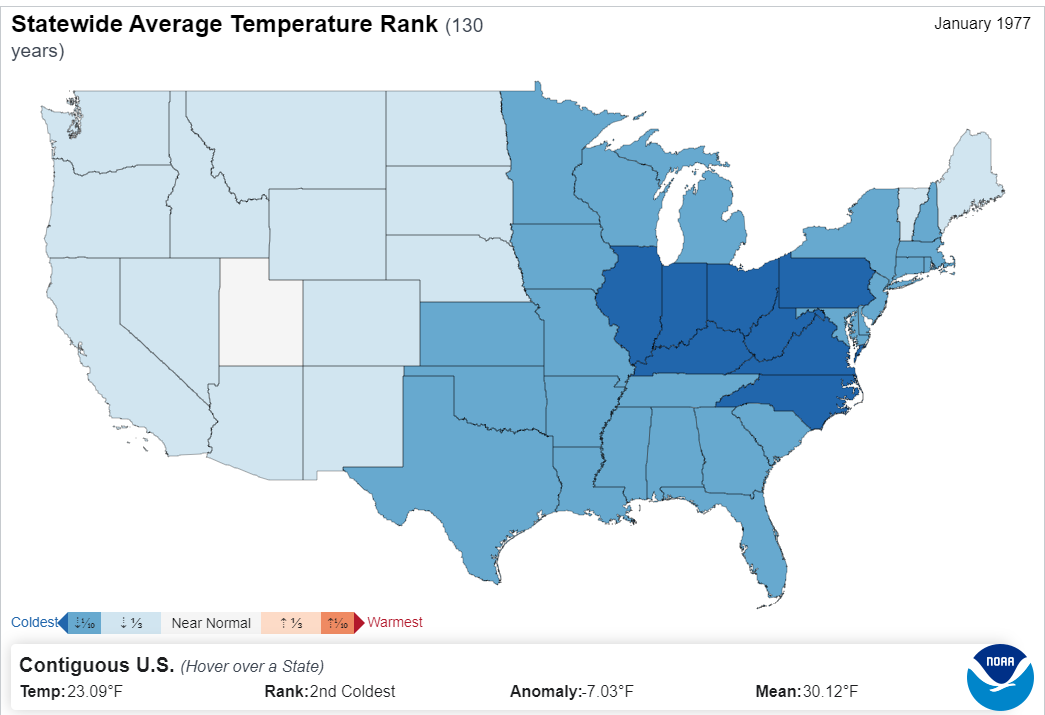
All of the ingredients mentioned above came together in December 1976 and lasted through the early part of February 1977. In Omaha, January was a chilly month with the average temperature being 13.2 degrees, which is 11.2 degrees below the January average of 24.4 degrees. The coldest stretch of that month occurred right in the middle. On January 16, the high in Omaha was 0, and the low was -21. January was a snowy month as well with 14.4" of snow falling, nearly double the 7.2" average. There was no big snow event, but a series of smaller snowstorms that dropped 1-3" during the month.

If you can believe it, Omaha got off lucky in January 1977, for the states east of the Mississippi River experienced one of the coldest months on record. A series of strong cold fronts blasted the Great Lakes and Ohio River valley with brutal cold and snow.
For several nights, temperatures plunged below -20 as far south as Cincinnati, Ohio. It was so cold that for the first time in living memory, the Ohio River completely froze over, and people could walk across it from Kentucky to Ohio. The frozen rivers created fuel issues as oil ships couldn't make it through the waters. As a foot of snow was on the ground, rock salt became useless and commutes to work or school were treacherous.

The cold wasn't just confined to the Ohio Valley, it plunged much farther south. A cold front on January 19 brought below-freezing temperatures to much of Florida, decimating the citrus crop. On the morning of January 19, snow fell across parts of Florida. In Tampa, 0.2" of snow fell, with other spots in central Florida picking up 2". For the first (and only) time in South Florida history, snow accumulated in Miami as temperatures dropped to a record low of 32 degrees. There were reports of snow mixed with rain in the Bahamas as well.

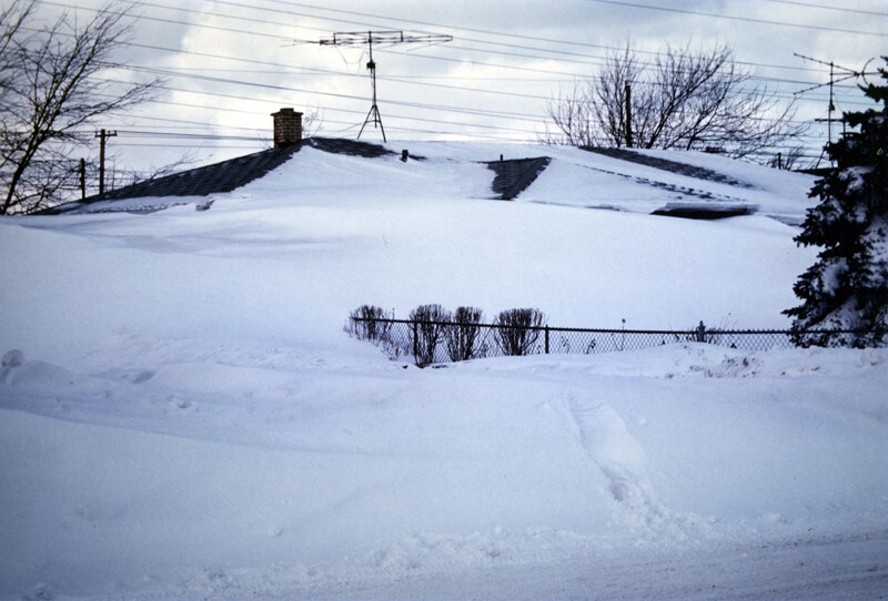
The extreme cold and heavy snow created another looming catastrophe. The unusual cold froze over Lake Erie very early in the season, by mid-December. Snow accumulated on top of Lake Erie and never melted. Due to the geography of Lake Erie, most of the snow piled up on its eastern shoreline, which is funneled directly into Buffalo, New York. On January 27, a powerful cold front swept across the lake bringing high winds and more snow. The high winds then picked up the thousands of square miles of snow and dumped it on Buffalo, and the result was truly historic. Snow drifts piled up as high as homes and covered cars. Those who were stuck outside were at risk of becoming buried in snow, literally. Snowmobiles had to be used to rescue people trapped in the snow, a challenging job as the snowmobiles had to dodge power lines and chimneys, that's how high the snow got. Some estimates placed snowfall totals (whether falling from the cold front or dumped from Lake Erie) as 100"! Tragically, the Buffalo Blizzard of 1977 led to 23 lives lost and many more suffering. It remains one of the worst blizzards in Buffalo's history.
After the Buffalo blizzard, the weather pattern changed in February and the tundra of the eastern United States started to thaw. Residents breathed a sigh of relief from Omaha and east, but this was only to be one of three brutal winters for the country.
WINTER 1977-1978
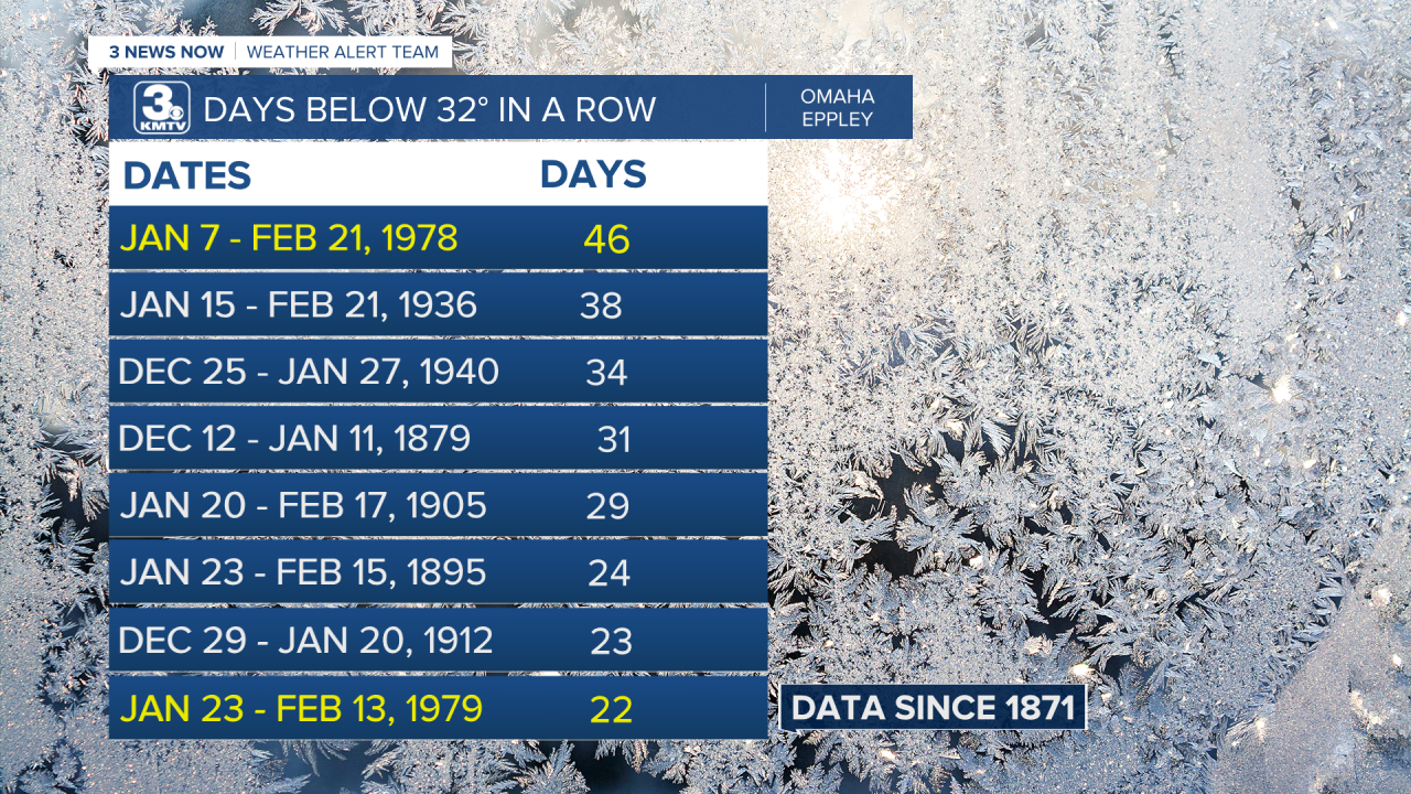
On January 6, 1978, the high temperature in Omaha was 38 degrees. The next day, the high temperature dropped down to 27 degrees as a cold front passed through. Little did anyone in Omaha know, that the 38 degrees felt on January 6 would be the last time it would be above freezing for a while. For almost the entire month, high temperatures struggled to reach 20 degrees while low temperatures frequently dropped below zero. A total of 16 days in January saw lows below zero, the 10th most in any January since 1871. In terms of snowfall, January was a dry month with only 4.0" of snow out of an average of 7.2" for the month.

The cold weather continued into February with highs continuing to be below freezing for the first three weeks. Finally, on February 22, the temperature rose back to 38 degrees. The 46 days spent below freezing was the longest stretch of below-freezing temperatures experienced in Omaha before or since.

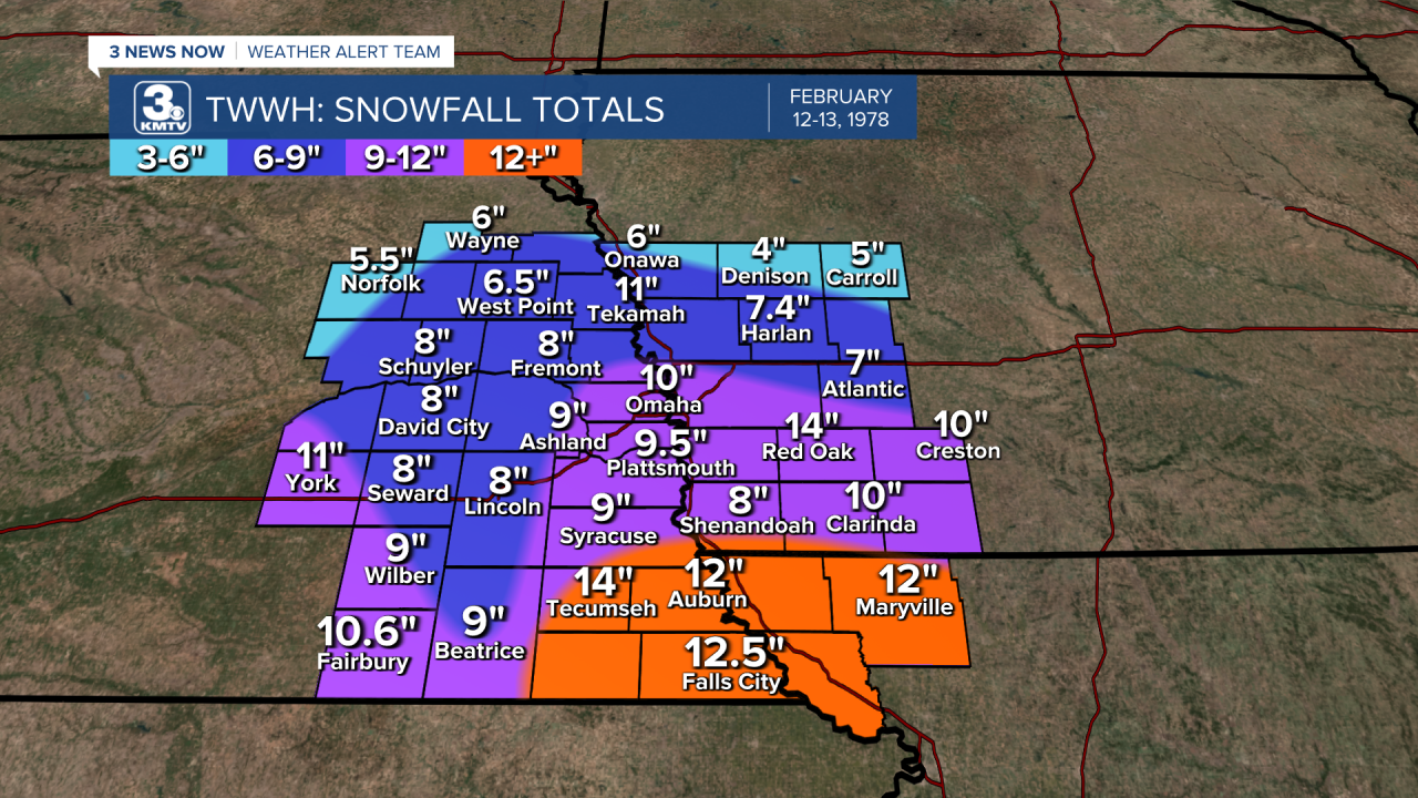
In terms of snowfall, snowfall did tick up substantially during the month. 6" of snow fell in Omaha from January 30 through February 1, the first bigger snowstorm of the season. Then came February 12-13 when 10" of snow fell in Omaha. The snowfall brought some issues, but the adequate warnings allowed the city to react quickly to the snow. Other smaller snowstorms brought the monthly February snowfall total to 22" in Omaha, the third snowiest February on record.
Overall, March was quite a chilly month too with highs barely breaking 40 for the first half of the month. However, the last week of the month brought a much-needed warm-up with highs in the 70s and 80s on the last few days. Although brutal, Omaha survived the winter of 1978-1979, once again the action was off to the east of the city.

In the final days of January, the conditions aligned perfectly for a storm of truly historic proportions to clobber the eastern Midwest. Known as the "Cleveland Superbomb", it brought snowfall over a foot and winds topping 80 mph. The hardest hit states were Michigan, Indiana, and Ohio. The storm shut down Ohio, leading to a General of the Ohio National Guard comparing its effects on transportation to a nuclear attack. Similar impacts were felt in Michigan and Indiana, where universities were closed for the first time due to winter weather, and travel was halted. The storm proved deadly, with around 90 people losing their lives due to the storm, 51 of those being in Ohio. It's not only the worst blizzard in that part of the country but in the United States as a whole.
Not even two weeks after the Cleveland Superbomb, another crippling blizzard swept through the United States, this time in the northeast. On February 6, thousands of people from New York City to Boston went to work and school, ignoring forecasts due to the perceived inaccuracy of the Weather Service. By mid-morning, heavy snow fell over parts of the Northeast, leading thousands to become stranded after leaving work. The blizzard brought historic snowfall to many major cities: Boston picked up 27.1", Providence RI 27.6", Philadelphia 20", and New York City over a foot. The impacts were immense, as the heart of the nation was paralyzed for days. To this day, it remains one of the worst Nor'Easters to impact the area.

WINTER 1978-1979
As the summer turned into the fall of 1978, many in the Midwest were hoping for a better winter than the two that had just been endured. As November gave way to December, those hopes quickly faded. The winter of 1978-1979 would be yet another severe winter, this time the impact would be greatest over the Corn Belt, including Omaha. December 1978 was cold in Omaha, but bearable. Highs generally sat in the 30s with lows in the teens. As well, 8.8" of snow fell in Omaha in December. It was only the precursor of what was to come in January to March.

"New Year Blows in Weather Headache" is not the headline one wants to read from the Omaha World-Herald on January 1, 1979. A major snowstorm barely missed Omaha to the southeast, dropping 2" in the metro but much higher totals into Kansas, Missouri, and Iowa. The bigger problems in the first few days of 1979 were the biting wind and brutal cold, wind chill values sank to below -25 in Omaha for the first couple of days.

It never warmed up. High temperatures were routinely in the teens, with lows falling below zero for much of the month. The average temperature in Omaha for January was 7.9 degrees, which officially makes it the coldest January on record. To put this number further into perspective, there were 18 nights in January when the temperature fell below zero, which is the 2nd most in January with the most being 19 in 1940.

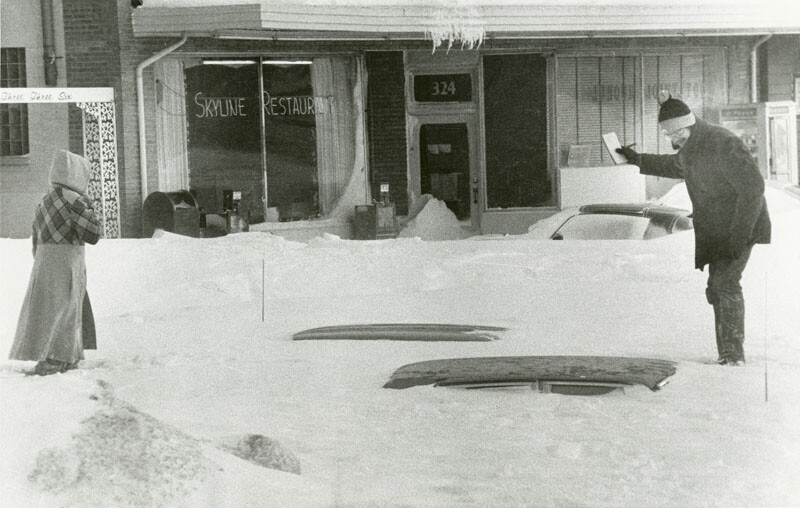
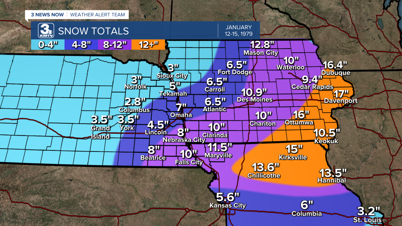
It wasn't just the cold that made things miserable, but heavy snow. The biggest snowstorm of the season came from January 12-15 and blanketed much of the Midwest in snow. Omaha picked up 7", causing headaches on roads due to a layer of ice underneath the snow. However, the snow totals were much higher further east. Amounts up to 20" crippled parts of eastern Iowa, closing down entire towns and highways for days. The Quad Cities were effectively cut off from the world for a time. In Chicago, 20" of snow shut down O'Hare Airport for 96 hours, which disrupted air travel internationally. It was one of the largest blizzards in Chicago history behind the big snowstorms of 1967 and 2011.
The cold continued into February with low temperatures frequently dropping below zero, particularly in the first half of the month. The coldest Omaha got was -17 degrees. By the end of the month, temperatures began to thaw somewhat but it remained cold. The average temperature in Omaha was 13.6 degrees, the third coldest February on record. Second place was 13.5 degrees, set just the year prior. However, the snow stopped in Omaha, with only 3.9" falling for the month.

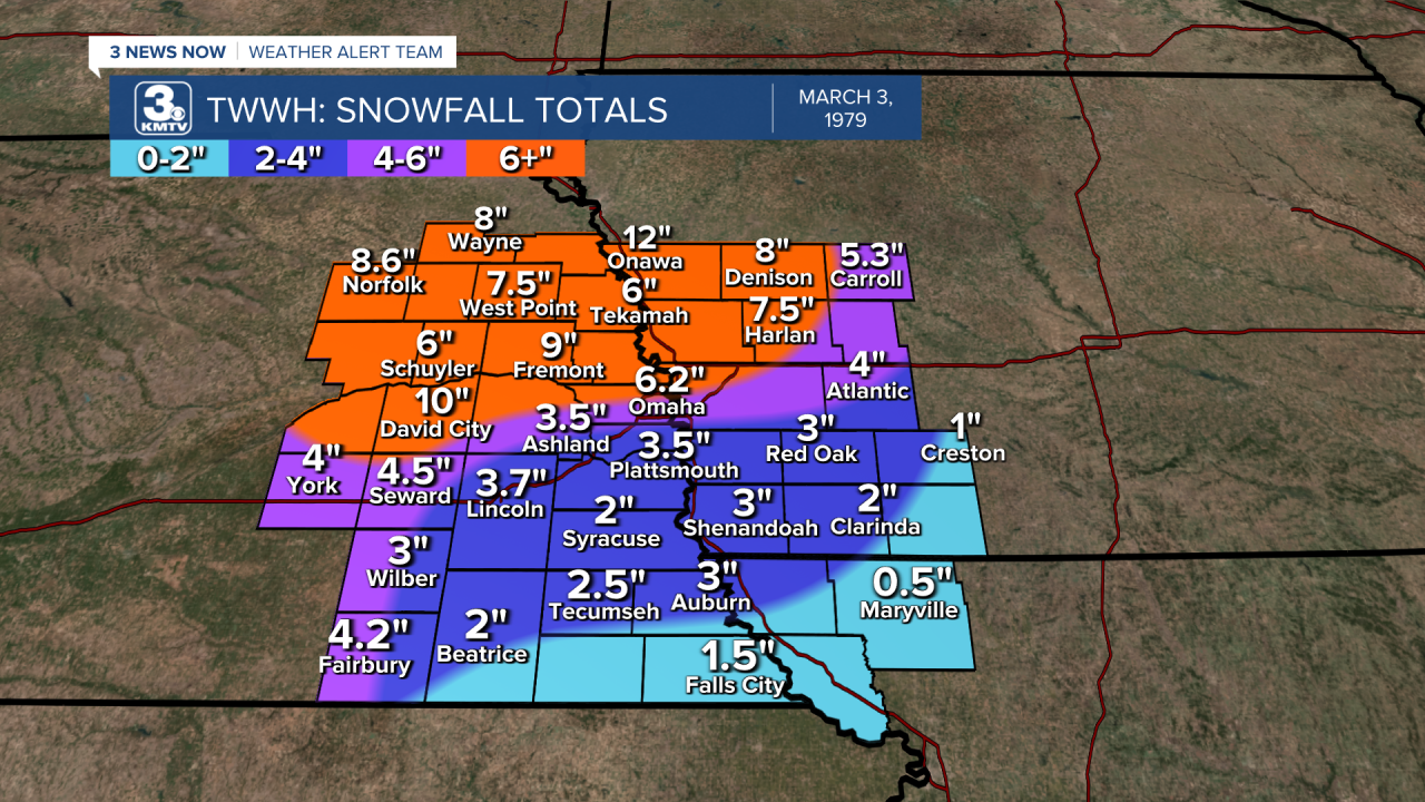
Winter was not ready to let go yet, a snowstorm in the first few days of March brought 6" to Omaha and 9" to Fremont. March remained cooler than average as well, but highs in the 70s by the end of the month led Omaha to forget about the brutal winter that was endured.
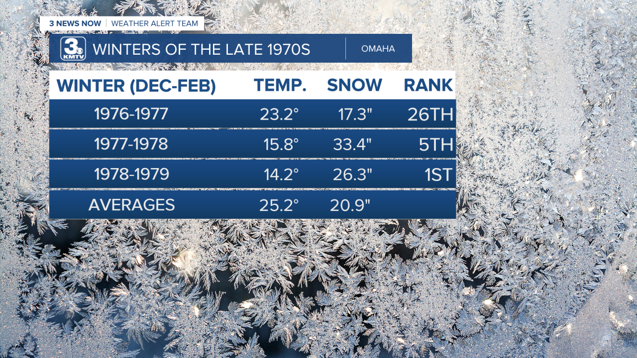
In terms of combined temperature and snowfall data, the winter of 1978-1979 is considered the worst winter endured in Omaha according to the Accumulated Winter Storm Severity Index (AWSSI), for more information on what the scale is, you can click here. The winter of 1977-1978 is the 5th, and the winter of 1976-1977 is lower.
It wasn't just Omaha, but across the entire country, December 1978-February 1979 is considered the coldest period nationwide, as was in Nebraska. For those who lived it, the brutal winters of the late 1970s are not ones to be forgotten anytime soon.

