
On April 3, 1974, residents of Omaha and surrounding communities woke up to snow falling. It was not a lot of snow, but by early April standards, it was quite impressive. The Weather Bureau station in North Omaha near 72nd and McKinley reported 2.3" of snow, while downtown had 1.3", and Eppley Airfield had a trace. Elsewhere, snow amounts remained generally under 2" or less except in Onawa IA which had close to 5" on the ground by April 4, 1974.
The storm system that brought 2" of snow to Omaha has gone down as one of the most infamous weather systems in US history, but not for the Omaha snow. In the warm sector, a swarm of violent tornadoes raked across parts of the eastern Midwest into the southeast. Within the span of an afternoon, over 100 tornadoes touched down, many of them violent. The hardest-hit states were Indiana, Ohio, Kentucky, Tennessee, and Alabama. However, tornadoes touched down as far west as Illinois, as far east as New York, and as far north as Canada. There were so many tornadoes that a special term, the Super Outbreak, needed to be coined. In this special installment of This Week in Weather History, the Super Outbreak of April 3, 1974, is looked at in terms of weather and human elements.
THE MAKING OF A SUPER OUTBREAK
About once in a generation, the meteorological ingredients align perfectly for a "Super Outbreak" as it has been termed. The first recorded "super outbreak" occurred on February 19-20, 1884, known as the "enigma outbreak" when at least 60 tornadoes moved from Alabama into the Carolinas, but Georgia was the most impacted state. On March 21, 1932, the next "super outbreak" happened, impacting Alabama hard. Then came 1974, and finally the super outbreak of April 27, 2011.
The storm system responsible for the April 1974 tornado outbreak came ashore in the United States on the evening of April 1. On the morning of April 3, this powerful low-pressure system was over Kansas and would move into Iowa during the day. Ahead of this low-pressure system was a large reservoir of warm, moist air from the Gulf of Mexico that would overspread much of the eastern US during the day. Already, the basic ingredients were there, but April 1974 had a few special components that would elevate the threat. The first was the dryline, common over the plains, which had moved as far east as the Mississippi River! The second was an expansive cap, or lid on the atmosphere which prevents thunderstorm development until the midafternoon. All of these ingredients were in place perfectly for the outbreak to begin.

All of these ingredients came together for a major outbreak, and it was known at the time. Allen Pearson, the Director of the National Severe Storms Forecast Center (NSSFC) in Kansas City, saw the potential for a major tornado event. On April 2, the day before the event, he telephoned every national weather service office in the eastern half of the country to perform maintenance on their radars, request extra staffing, and prepare satellites to go into severe weather mode. His forecast likely allowed the weather service to operate at full capacity, which allowed them to tackle the unfolding horror of the next day.
THE TORNADOES
On the morning of April 3rd, a line of strong thunderstorms (shown in green in the below image) was moving across parts of the Ohio Valley into Tennessee. This line was responsible for the first bout of tornadoes by early afternoon over southeast Tennessee, northern Georgia, and western North Carolina.


Around 1 pm, the main event began to fire out west as supercell thunderstorms developed in two bands. The first band formed from eastern Missouri into Illinois, while the second band formed near the Mississippi River from Paducah to Nashville. After 2 pm, the outbreak began.

The northernmost band produced tornadoes first. In St. Louis, wind-driven baseball-sized hail shattered windows, which was the costliest storm in the city's history up to that point. By 2:30 pm, the storms over eastern Illinois began to produce tornadoes. One F-3 tornado moved over the northern part of Decatur, a town of roughly 80,000 people. 35 homes were destroyed in the city, and 1 person lost their life. Three other F-3 tornadoes occurred in Illinois before the storms moved into northern Indiana.


In northern Indiana, one supercell put down an F-4 tornado that would travel 108 miles, the longest-track tornado of the entire outbreak. The tornado hit the town of Monticello head-on, and much of the city suffered extensive damage including the county courthouse. The tornado continued into several more towns before lifting not too far from the Michigan border. 18 people were killed and over 300 injured in the Monticello tornado.
As these tornadoes were ongoing to the north, the second band of supercells (red shaded in the graphic above) started to produce tornadoes around 2:30 pm, and would not stop producing tornadoes for many hours.

The first two tornadoes would be rated F-5s, and both developed at the same time. The first F-5 tracked over 60 miles through southern Indiana, just north of the Ohio River. This tornado grazed the southeast side of the small town of Depauw and also through the small town of Daisy Hill. An elementary school in Daisy Hill was hit with several classrooms destroyed, although no one was in them as the students and staff sheltered in the hall. Some were not so lucky, in the Depauw-Daisy Hill F-5, 6 people were killed and 86 people were injured.
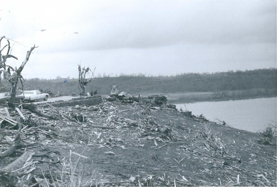
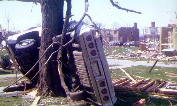
At the same time the Depauw F-5 tornado formed, a second F-5 tornado occurred in northern Kentucky about 30 miles south of the first F-5. This tornado grazed the northern edge of Hardinburg, Kentucky producing moderate damage. The tornado intensified as it approached the town of Irvington, but it missed the city to the north. Tragically, the tornado plowed into the riverside town of Brandenburg at maximum F-5 intensity. Many homes were swept off their foundations with almost nothing left, and strong brick buildings were reduced to rubble. Along Green Street, 18 people lost their lives as the tornado sliced through the town. Vehicles had nothing but frames left. Even concrete headstones at a nearby cemetery were lofted across the river into Indiana. After devastating Brandenburg, the tornado dissipated across the river in Indiana. 31 people were killed in the Brandenburg F-5, one of the strongest tornadoes of the entire outbreak.
By 4 pm, the super outbreak was in full swing as many supercells were producing violent tornadoes over a broad area. In Indiana, so many storms were around that at one time the entire state was placed under a tornado warning to deal with the threat. Tornadoes expanded southward into Tennessee and the rest of Kentucky, and also moved north into eastern Indiana.

East of Indianapolis, several violent tornadoes raked through the eastern side of the state. One F-4 tornado hit the town of Kennard at 3 pm. That same supercell continued northeast and dropped another F-4 tornado near Parker City at 3:35 pm. Both of these tornadoes were widely photographed and filmed. To the south, an F-4 tornado hit the town of Hamburg.
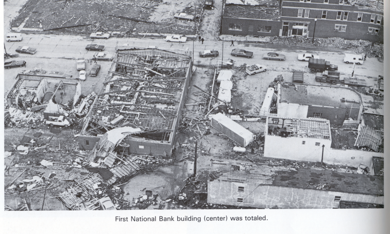
Into central Kentucky, more supercells dropped tornadoes. An F-4 tornado moved near the town of Leitschfield at 4 o'clock. The same supercell continued northeast and produced another F-4 tornado 45 minutes later that moved over the north side of Elizabethtown. At 5:50 pm, a tornado over a mile wide went through the southern section of the capital city of Frankfurt where 120 homes were destroyed.

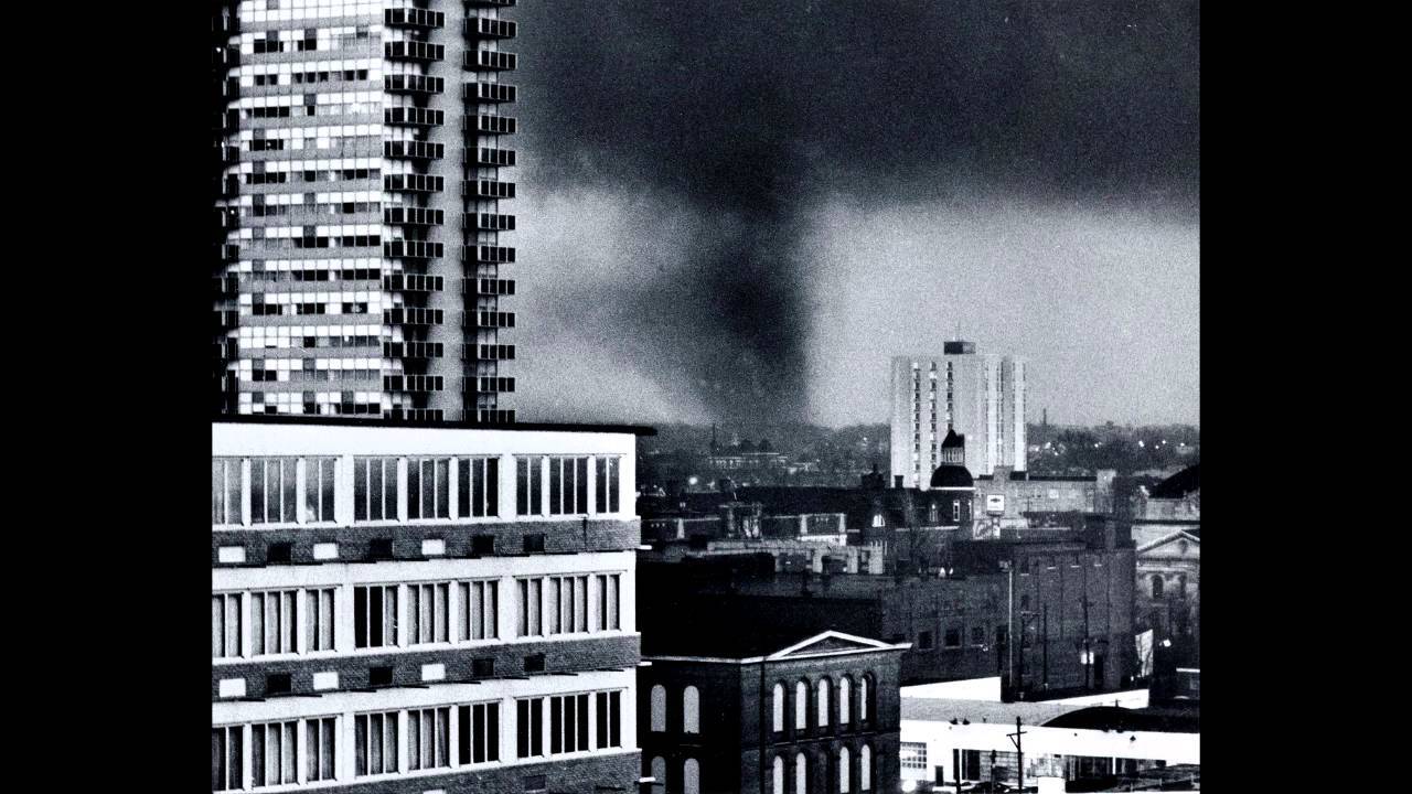
At the same time, the central Kentucky tornadoes were going on, the same supercell that produced the Brandenburg F-5 was heading for Louisville, the largest city in Kentucky. Dick Gilbert, a helicopter traffic reporter for WHAS-AM radio, was following the storm as it moved into the Louisville metro. He tracked the storm in real-time as an F-4 tornado touched down near the Louisville International Airport near the fairgrounds. It crossed I-65, throwing many cars. Due to the real-time updates given on the radio, which you can listen to here, many took shelter as the tornado passed through. By the time the tornado lifted in the eastern suburbs of Louisville, 3 had died and over 900 homes were destroyed. Many attribute the low death toll to Dick Gilbert and the WHAS crew for their coverage of the tornado.
Louisville was not the only metro area to be impacted that afternoon, as the supercell that produced the Depauw F-5 tornado was heading for the Cincinnati OH metro area. After dropping the Depauw F-5, the tornado quickly dropped an F-4 at 3:19 pm that plowed through the town of Hanover Indiana. The tornado then hit the western side of the riverside community of Madison IN, where 7 people were killed and over 300 homes destroyed. 4 more people were killed in rural areas. At 3:40 pm, the storm dropped a second F-4 tornado that hit the town of Fairview.

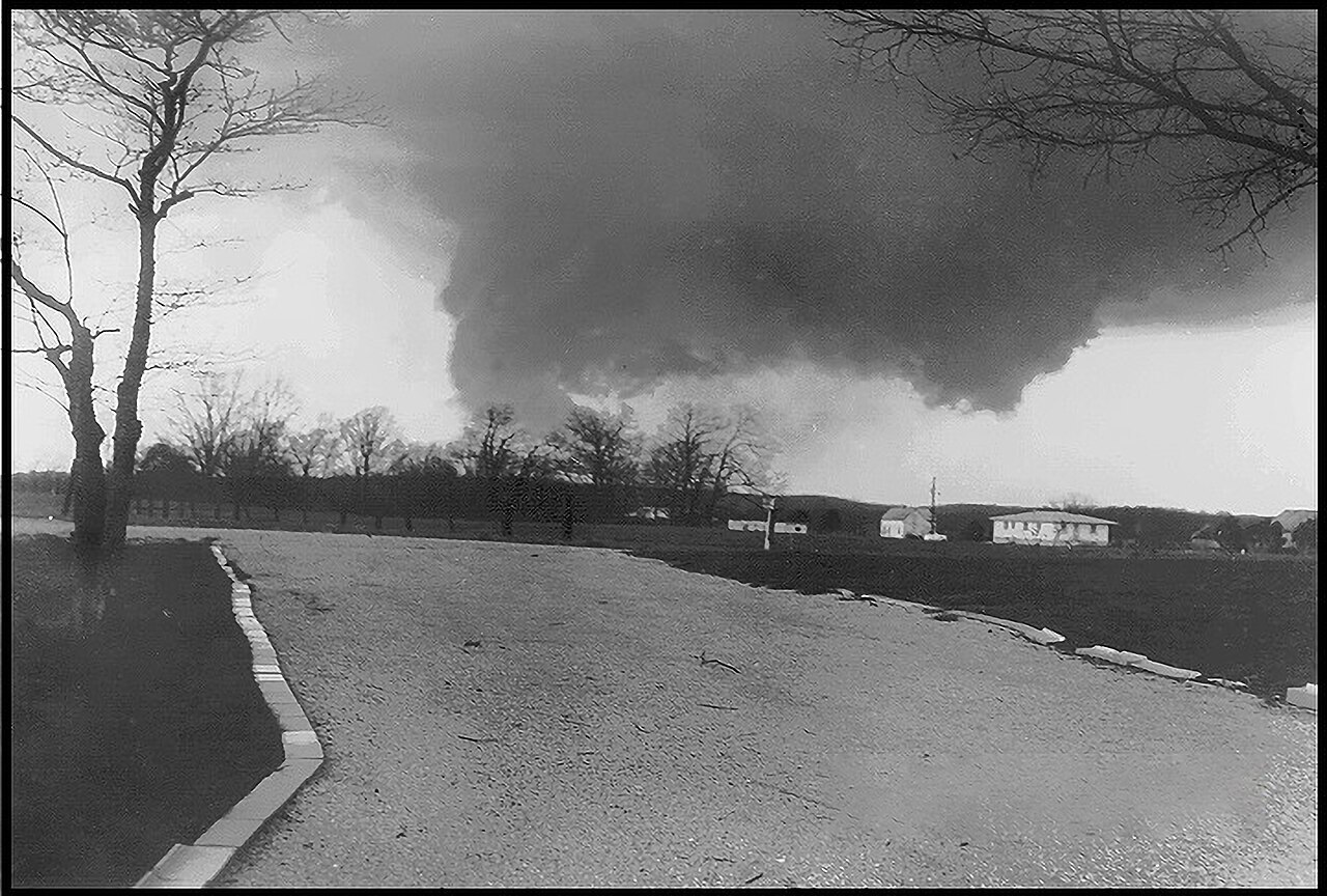
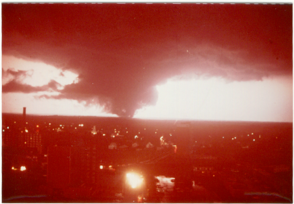
As the tornado approached Cincinnati, it dropped what would become an F-5 at 4:20 pm in far southeast Indiana. It then crossed the river into far northern Kentucky where it strengthened, then it crossed the river yet again into Ohio. The tornado slammed into the Cincinnati suburb of Salyer Park, on the banks of the river in the western suburbs. The Salyer Park F-5 tornado hit a marina where boats were overturned, and a floating restaurant was broken from its moorings and flipped to float down the river. Many homes were leveled in Salyer Park. Like Louisville, thousands of people watched the tornado live on TV as it moved into town. The Salyer Park F-5 is one of the most photographed tornadoes of the event as it was highly visible to thousands of Cincinnati residents. 3 people were killed in this F-5. Over the northeast side of Cincinnati, an F-4 tornado occurred in the northeast suburbs doing more damage.

The Salyer Park F-5 was not the only F-5 in Ohio that day. An hour earlier, a lone supercell developed between Cincinnati and Dayton and moved northeast. As the storm approached Xenia, a large town just east of Dayton, at 3:30 pm it would produce perhaps the strongest tornado of the entire event. The tornado entered the southwest side of Xenia at F-5 intensity, flattening two subdivisions. The tornado destroyed everything in its path as it tore through the city of 25,000. At Xenia High School, theatre students were practicing for a play when they heard the tornado and took shelter in a nearby hallway. Seconds later, a school bus was dropped onto the stage. All of the students survived. The Xenia tornado was the deadliest tornado of the entire outbreak, with 32 lives lost. The tornado damage was so extensive that Dr. Ted Fujita, the founder of the F-Scale, assigned the Xenia tornado as "F-6" which was not even on the scale. It was downgraded to an F-5 as the F-6 category was dropped.

After 5 pm, many of the supercells from Kentucky northward stopped producing tornadoes as they moved into Ohio. Into the evening, attention began to turn farther south into Tennessee, southern Kentucky, and northern Alabama. The outbreak was far from over.


Through the evening hours, multiple waves of supercells produced violent tornadoes in a smaller cluster in northern Tennessee and southern Kentucky. Many of these reached F-3 and F-4 intensity as they moved through mostly rural and hilly sections of the states.

The height of violent tornadic activity was centered over northern Alabama through the rest of the evening.

Around 6:30 pm, the first of what would be three F-5 tornadoes formed in northern Alabama near the town of Moulton. This tornado would stay on the ground for over 90 minutes and travel 52 miles through northern Alabama. The tornado slammed into the small community of Tanner, west of Huntsville. The city was nearly destroyed, with many homes leveled and cars mangled. The tornado also brought significant damage to the Huntsville suburb of Harvest, where more substantial damage occurred. In the first Tanner F-5, 28 people lost their lives and over 250 people were injured.

As search and rescue began in Tanner and Harvest, a second supercell followed on the heels of the first one. At 7:35 pm, an hour after the first F-5, a second F-5 tornado formed and followed almost the same path as the first one, only moving about a mile further west. In one tragic instance, a man who was injured in the first F-5 was moved to a church to be helped. When the second F-5 came through, the church collapsed and killed the man. Tanner and Harvest were hit again, causing more damage. This second F-5 went further into the northern Alabama town of Hazel Green, and even into Tennessee where it dissipated. Over 1,000 homes were destroyed by this second F-5. There is some controversy over the tornado's rating, as scientists at the time and today believe it only achieved F-4 intensity. However, the official rating is still F-5.
While the Tanner tornado was still ongoing, an F-4 tornado developed in far west Alabama around 6:30 pm and moved through the town of Jasper, a town northwest of Birmingham. The tornado moved directly through downtown Jasper, destroying many buildings and injuring over 100 people. 3 people were killed in the Jasper F-4.

The final F-5 occurred after dark and would be the longest track of all the F-5s from the outbreak. This tornado touched down near the Alabama/Mississippi border and moved directly over the small town of Guin. The damage was catastrophic in Guin, where 28 people would be killed. Not only were homes swept away, but in some cases, entire foundations were swept away. Trees were debarked, and parts of the ground were ripped out. Behind the Xenia F-5, the Guin F-5 was the second strongest tornado of the event. It carved a path of nearly 80 miles, and today it's one of the most intense tornadoes to impact Alabama in history.
The same supercell that produced the Guin tornado would impact the third and final metro area, Huntsville. An F-3 tornado moved over the south side of Huntsville shortly before 10 pm and over the Redstone Arsenal. More tornadoes formed over Tennessee, Kentucky, West Virginia, Virginia, Georgia, and North Carolina into the nighttime hours. One tornado formed in New York, and another in Windsor, Canada. By the morning of April 4, the outbreak was over, but the cleanup had only just begun.

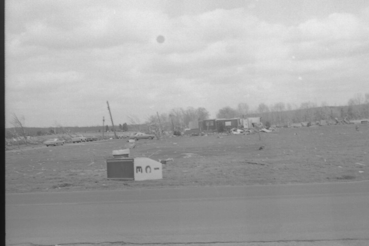
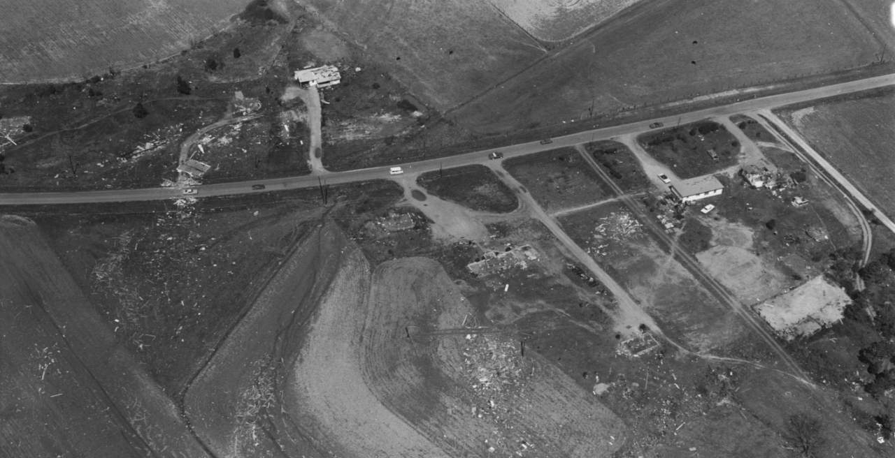
The statistics from the outbreak are staggering. 148 tornadoes, 319 fatalities, thousands injured, and many more thousands of homes destroyed. The damage in 1974 dollars was around $843 million, which adjusted for inflation would be roughly 5,300,000,000 dollars today. The outbreak helped to dispel many myths about tornadoes such as they can not cross rivers, or that they can not impact metropolitan areas. The lessons from 1974 are still in place today, and 50 years later the super outbreak of 1974 remains as one of the most destructive tornado outbreaks in US history.
