


March 25-29 is Severe Weather Awareness Week for Nebraska and Iowa. Each day, a different aspect of severe weather will be highlighted, explaining the science behind them, and how you can stay safe when severe weather threatens. This article will focus on how severe weather watches and warnings work, as well as an explanation of the severe weather threat scale.
THE SEVERE WEATHER THREAT SCALE
To describe a severe weather threat, a 1 to 5 scale is used to describe the particular risk of severe weather that parts of eastern Nebraska and western Iowa can face on a particular day. In a year, we see about 50 days in some sort of severe weather risk. The scale of 1 to 5 is based on the severity and coverage of the storms.
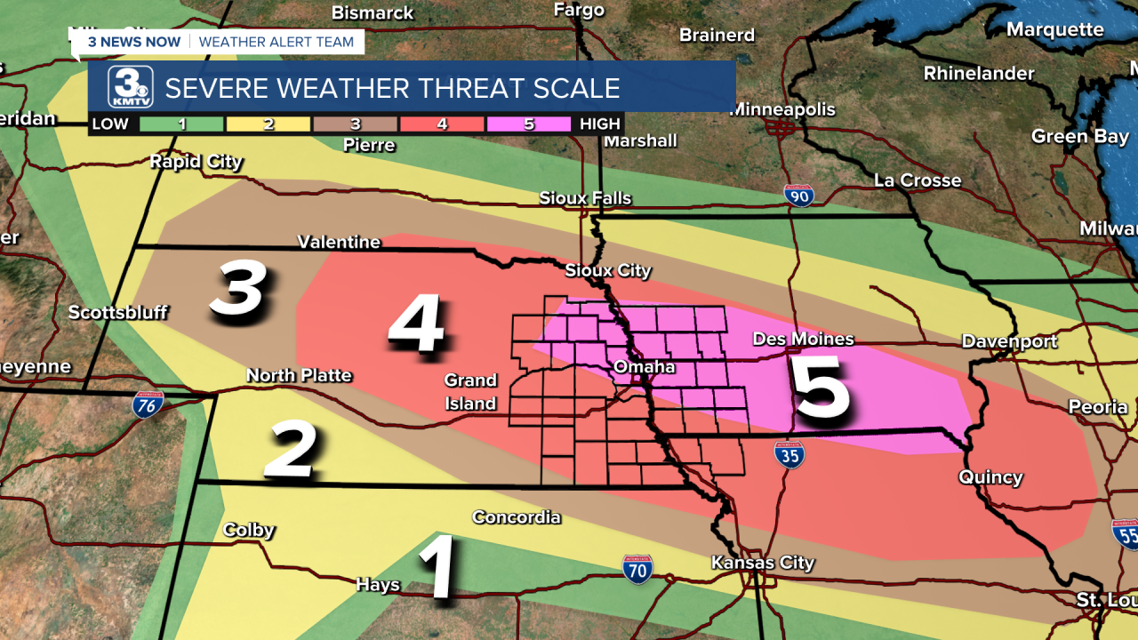
LEVEL 1 (GREEN) - This is the lowest risk. While thunderstorms are possible, the overall risk of severe weather is low. These can produce damaging winds, large hail, or an isolated tornado, but they would not be widespread.
LEVEL 2 (YELLOW) - The level 2 risk is the "standard" risk for severe weather. A few thunderstorms are expected to become severe with large hail, damaging winds, and a few tornadoes possible. Of the 50 severe weather risks we see in a year, around 35 of them are a level 2 or higher risk.
LEVEL 3 (ORANGE) - A level 3 risk is when severe weather chances increase. In a level 3 risk, numerous storms are expected to become severe with large to very large hail, significant damaging winds, and several tornadoes possible with a few on the stronger side. Of the 50 severe weather risks we see in a year, around 3 of them are in a level 3 or higher risk.
LEVEL 4 (RED) - A level 4 risk is issued when a significant severe weather or tornado outbreak is expected. A level 4 risk is relatively rare for Nebraska and Iowa. The last time a level 4 risk was issued for our area as of March 2024 was back on December 15, 2021, when our viewing area experienced over 30 tornadoes. In a level 4 risk one could expect widespread large hail, damaging winds, and numerous tornadoes with a few strong tornadoes possible.
LEVEL 5 (PINK) - A level 5 risk is the highest category that denotes a significant to possibly historic severe weather or tornado outbreak. Level 5 risks are rare anywhere in the US, including Nebraska and Iowa. Since 1987, only 21 level 5 risks have been issued that include Omaha. The last time we saw a level 5 risk was on June 3, 2014, nearly 10 years ago! (That day was the Blair hailstorm).
WATCH VS WARNING: WHAT IS THE DIFFERENCE?
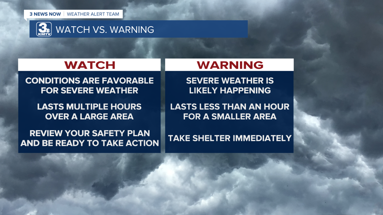
A watch means that conditions are favorable to the development of severe weather, but they are not imminent. A Severe Thunderstorm Watch means that conditions are favorable for the development of storms capable of producing large hail and damaging winds. Meanwhile, a Tornado Watch means that not only are conditions favorable for the development of tornadoes. Watches are usually issued over a several-hour duration and span over a wider geographical region where conditions are favorable. A watch means to pay attention to the weather, but you do not need to take any urgent action.

A warning means that the threat of severe weather is occurring or imminent to your specific neighborhood. A Severe Thunderstorm Warning means that a severe thunderstorm is occurring or imminent. A Tornado Warning means that a tornado is occurring or is imminent in a specific location. A warning lasts less than an hour until the threat is either moved on or weakened. Warnings also cover a smaller geographical area, typically less than the size of a county depending on the storm.

WAYS TO GET SEVERE WEATHER ALERTS
In today's age, there are many ways to receive weather alerts. Remember to have multiple ways to get alerts in case any one of them fails. The more ways you can be alerted for severe weather, the better likelihood you will get the warning and take action. Here are a few ways to receive alerts:
Weather Radio - You can purchase a weather radio at most stores. These sound an alarm when an alert is issued. You can program them to only sound for specific alerts. Weather radios will alert you of both watches and warnings.
Wireless Emergency Alerts (WEA) - Most phones have this feature pre-installed and turned on. This is the same system that Amber Alerts are transmitted for. Wireless Emergency alerts will only sound in a Tornado Warning or a Severe Thunderstorm Warning where the hazards are baseball-size hail and/or 80+ mph winds. Although your phone automatically has them enabled, make sure you have them enabled by checking the WEA settings.
Television - At the bottom of our screen is a crawl that displays any watches and warnings that are in effect. This should be a secondary way to get alerts, as the TV needs to be on to see the alerts.
Phone Apps - Hundreds of phone apps will alert you when dangerous weather approaches, some more reliable than others. The 3NewsNow app and the Storm Sheild App both have alerts that will sound in dangerous weather, and these alerts are customizable.
Outdoor Warning Sirens - While useful, outdoor warning sirens should never be your only way to get alerts as they are meant for outdoor use. Even if you can hear them inside, the chances of hearing them in the middle of the night during a raging thunderstorm are lower. Thus, have multiple ways to receive alerts!
