

It's a common saying in the Midwest, "Don't like the weather? Wait a few minutes," and on December 15, 2021, that moniker was put to the test. Just 5 days after a historic tornado outbreak swept through areas southeast of Omaha, an even more unusual event had Omaha right in its sights.
It's easier to mention what the weather in Nebraska or Iowa didn't see on that day. On this day, Nebraska and Iowa experienced: record-obliterating high temperatures, ferocious winds both inside and outside thunderstorms, dozens of tornadoes, dust and smoke from Kansas blanketing cars, and even snow in northeast NE. In this installment of This Week in Weather History, we look back at that wild day and all the variety of weather it brought to Nebraska and Iowa.
DECEMBER 15, 2021, IN CONTEXT
December 15, 2021, was a highly anomalous event. As such, a baseline of what Nebraska and Iowa have seen in December is necessary.

As is to be expected, tornadoes in Nebraska and Iowa in December are rare, very rare. Since the 19th century, Nebraska has only seen 5 tornadoes. In 1975, an F-2 tornado struck Pawnee County and another near Hebron. More recently, three tornadoes touched down near Kearney on Christmas Day 2016. In Iowa, 6 tornadoes have occurred during the month. Most are from December 23, 2015, in eastern Iowa.

Outside of tornadoes, severe thunderstorms in December are rare in Nebraska and Iowa. The only other severe weather event in Nebraska in recent years was Christmas Day 2016.
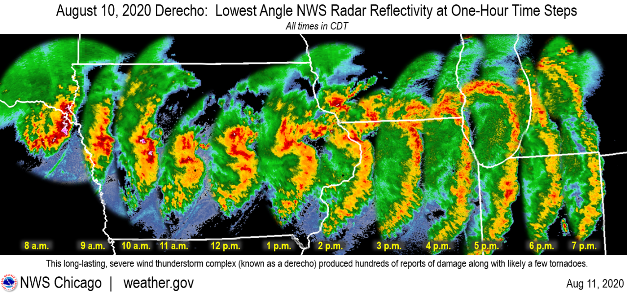
Across the nation, there has never been a derecho in December. A derecho is a fancy term for a long-lived damaging wind storm, and specific criteria need to be met before classification as a derecho, such as being a consistent swath of winds over 250 miles long. The most famous derecho happened in Iowa on August 10, 2020.
In terms of record warmth, hitting the 70s in December is about as rare as seeing tornadoes. Since 1871, Omaha has only hit the 70s three times before 2021: December 10, 1890 (71 degrees); December 13, 1921 (70 degrees); and December 6, 1939 (72 degrees). Des Moines had never hit the 70s in December before 2021.
While it often is windy in Nebraska and Iowa during the winter, it's rare to see a windstorm with non-thunderstorm winds over 60 mph. The only comparable event was November 10, 1998, with wind gusts in the 50-60mph range across Nebraska and Iowa.
THE SET-UP
5 days before December 15, on December 10, a violent tornado outbreak with 71 tornadoes impacted areas southeast of Omaha. Strong to violent tornadoes struck Arkansas, Missouri, Tennessee, Kentucky, and Illinois, among others. A supercell produced two EF-4 tornadoes during its lifespan. The first EF-4 impacted northeast Arkansas, the Missouri Bootheel, and northwest Tennessee. The second plowed through western Kentucky. In particular, the town of Mayfield was heavily damaged, with much of the business district destroyed. Other strong tornadoes impacted the St. Louis, Bowling Green, KY, and Nashville metro areas. It was the deadliest December outbreak on record, with 89 confirmed deaths, most of them being from the Mayfield tornado.

As the nation mourned the tragedy of December 10, forecasters were looking ahead to the middle of the coming week, when another storm system was forecast to traverse the country. This time, the storm system would be further north, meaning any severe weather threat would not be over the same areas devastated on December 10.
This storm system caught meteorologists' eyes in Nebraska and Iowa nearly a week out for one thing at first: record warmth. Computer model data was suggesting temperatures by Wednesday, December 15 would be in the 60s and even the 70s. The record high in Omaha on December 15 of 61 was almost guaranteed to be beaten, but the all-time December record high of 72 was in jeopardy, too.

The reason for the warmth was the extreme dynamics that the storm system would bring. The winds inside this area of low-pressure were exceeding the climatological maximum, a fancy way of saying it's never been seen before since data was compiled in the 1950s. A typical wind field for a December low-pressure system is winds at 5,000 feet roughly blowing around 40mph, while winds at 18,000 feet can be as high as 70mph. The system on December 15 was looking to double that, with winds around 5,000 feet in the 80mph range, while winds at 18,000 feet were being forecasted to climb as high as 140mph.

With such extreme winds above the ground, it was probable some of that would be brought down to the surface, meaning wind gusts over 60mph were very possible. For context, severe thunderstorms produce winds exceeding 58 mph.
With winds that extreme, a variety of hazards are expected:
1.) tree/powerline damage, leading to power outages;
2.) very high fire danger, as any grass fire that starts would burn out of control within minutes;
3.) High-profile vehicles could be blown over, leading to traffic issues. In fact, for the first time, Omaha Public Schools canceled classes not for snow, but for extreme winds, as school bus safety was a concern.

The final piece of the puzzle was not considered until a few days before the event: the severe weather threat. Lack of moisture/instability (storm fuel) precludes December tornadoes in our area. If there is no instability, thunderstorms cannot form and become severe. This was the main sticking point for severe weather on December 15: how much moisture would there be to sustain a severe weather threat?
For this reason, forecasters were cautious with severe risks. On December 13, the Storm Prediction Center issued a level 1/5 severe risk for parts of northern Iowa. The next day, that risk was upgraded to a level 2/5. On the morning of December 15, the threat was significantly upgraded to a level 4/5 severe weather risk, rare even during the peak of tornado season. The last time eastern NE/western IA was in a level 4/5 risk was June 16, 2017, the day an EF-2 tornado moved through Bellevue and the metro experienced over 100mph winds. Before 2021, eastern NE/western IA was never in a risk for severe weather in December!

All of this meant the system was going to be bad, and once December 15 rolled around, it certainly lived up to the expectations of what the day would bring.
THE WARMTH
Nebraska and Iowa awoke to temperatures already in the upper 50s, nearly 20 degrees above the average high temperature. Those temperatures would climb into the low 70s for almost everyone. Omaha hit 74, the all-time December record high, and the 4th time since 1871 Omaha hit 70 degrees in December.

THE NON-THUNDERSTORM WIND
All day, the winds howled across eastern NE and western IA. Wind gusts ahead of the line of thunderstorms were already gusting to 45-55 mph, snapping a few power lines near Red Oak, Iowa. As the storms cleared the viewing area by 6 pm, winds behind the storms gusted over 60mph at times. The peak wind gust in Omaha was 70 mph.

THUNDERSTORM WIND
By 1 pm, a line of storms developed in northwestern Kansas. This line of thunderstorms raced through the Midwest at 60-70 mph, ending in Wisconsin by midnight. The storms brought widespread damaging winds to Kansas, Nebraska, Iowa, Missouri, Minnesota, Illinois, and Wisconsin.

Wind gusts over 80mph were common, with the highest wind gust at 93 mph in Lincoln.


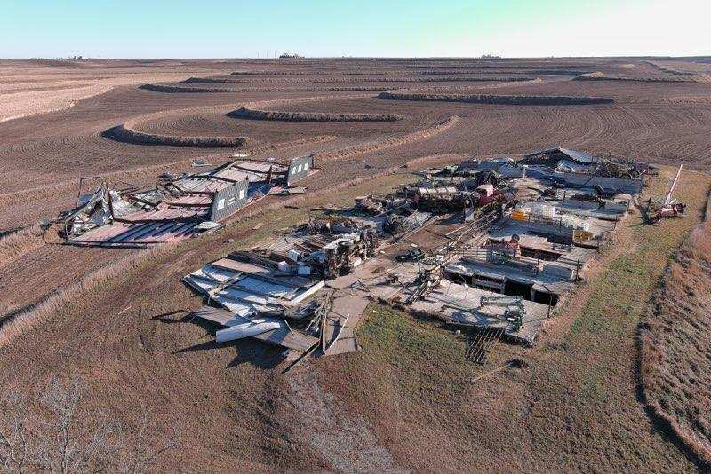
In 2025, UNL researchers, in conjunction with the National Weather Service, examined wind data from several weather stations on a farm southeast of Mead in Saunders County. They determined that a thunderstorm wind gust of 128 mph occurred outside of a tornado. This would make it the highest recorded wind gust in Nebraska history, not from a tornado!
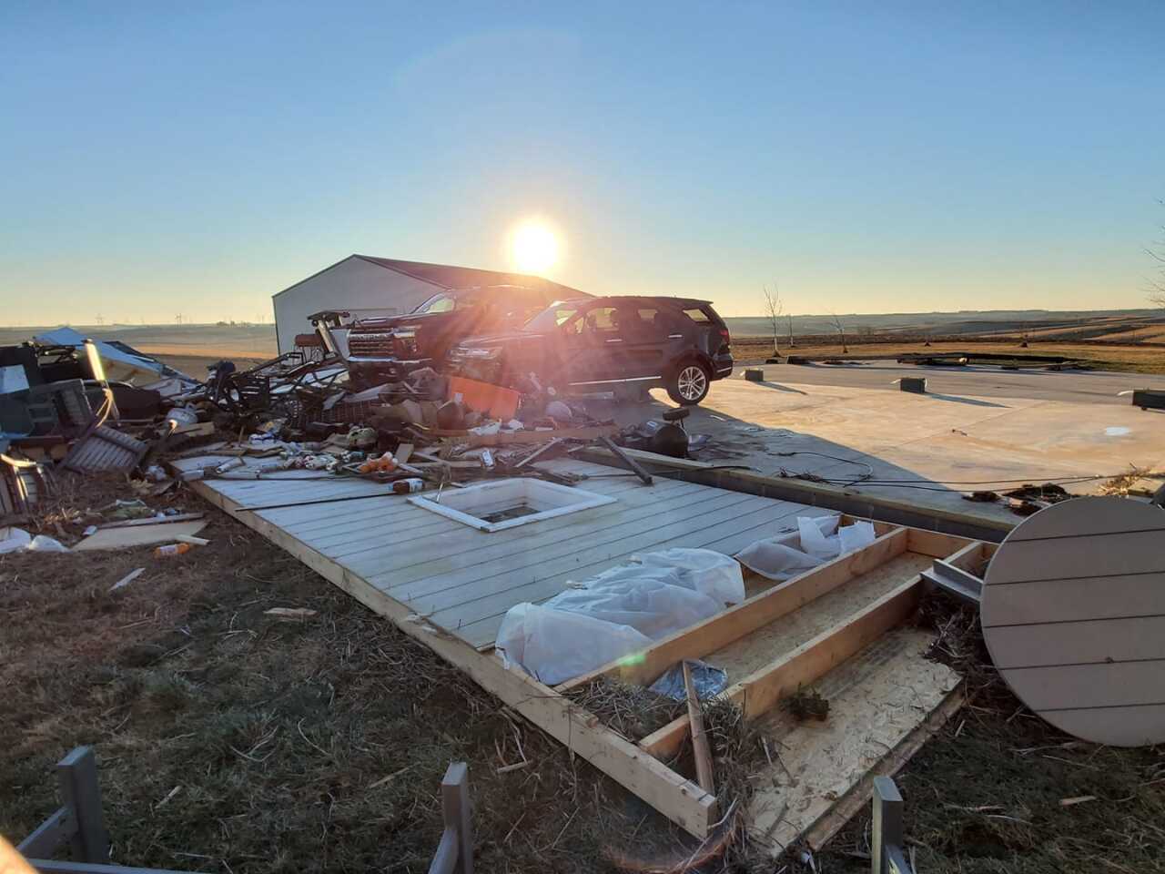
THE TORNADOES
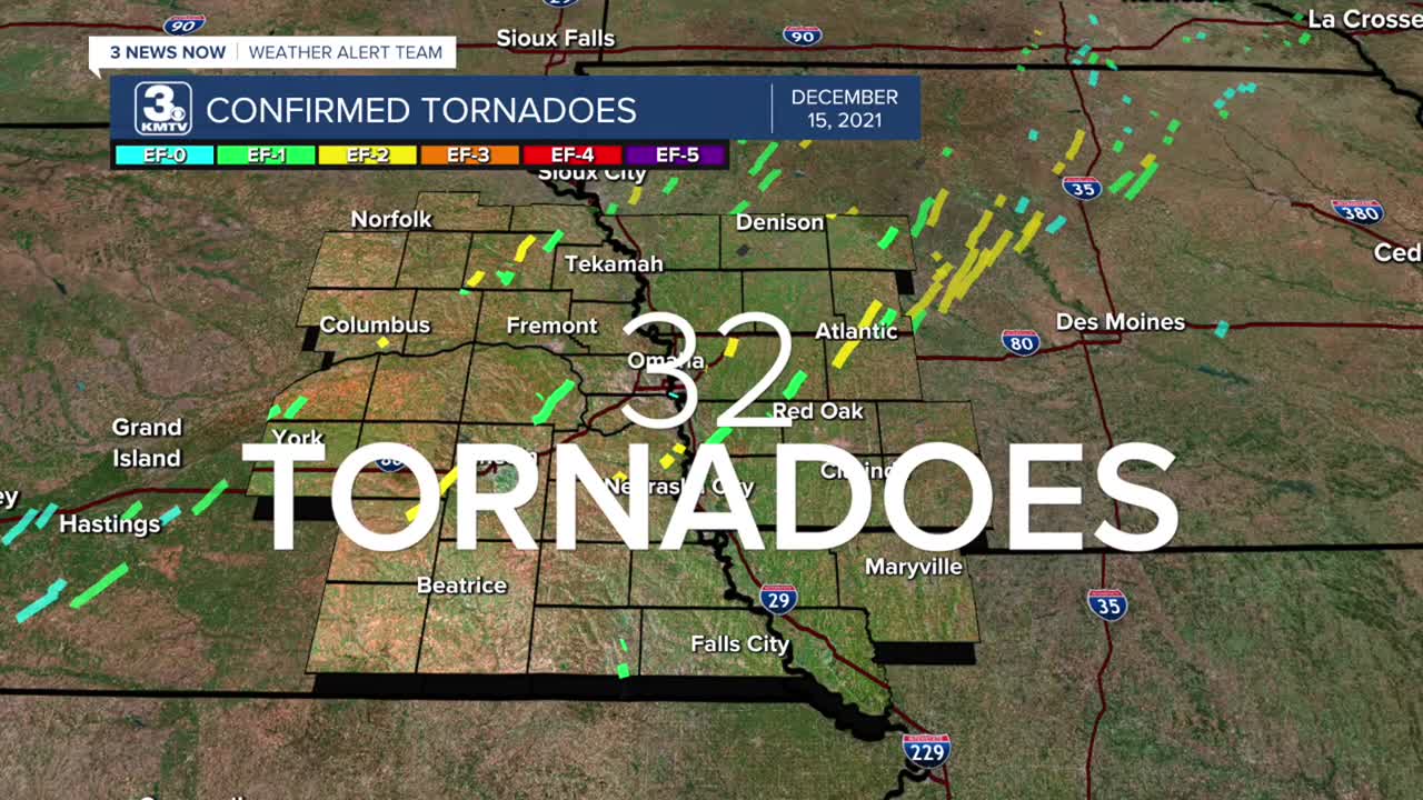
The line of thunderstorms was incredibly prolific in producing tornadoes. In the KMTV viewing area alone, 32 tornadoes were confirmed. The highest amount of tornadoes seen in one day in our area. The second highest is 18 tornadoes from the May 12, 2023, tornado outbreak. Below is a summary of all 32 tornadoes.

———

1. West Polk (Polk County) EF-1: Snapped power poles and overturned irrigation pivots in southwest Polk County.

2. East Polk (Polk County) EF-1: Snapped power poles and overturned irrigation pivots between Polk and Stromsburg; a couple of homes had some roof damage.

———

3. Platte Center (Platte County) EF-1: Destroyed a building on the southeast side of town; other homes in Platte Center experienced minor damage.
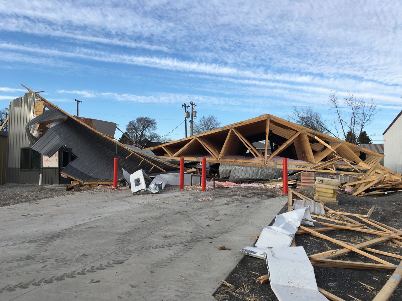
4. Columbus (Platte County) EF-2: Started in the town center, destroying a roof off a ranch home. It continued through the north side of town, damaging homes before lifting. This incredible video shows the small and very fast tornado.

———

5. Howells (Colfax County) EF-1: Moved south to north through the east side of Howells, damaging a home and snapping trees. It lifted just north of town.

6. SW Cuming County EF-2: Began NE of Howells, a barn was tossed over 100 yards away, and others were destroyed.

7. 3 W of West Point (Cuming County) EF-1: Snapped power poles and caused damage to a shed.

8. 5 W of West Point (Cuming County) EF-1: A brief tornado snapped a few power poles and trees in southern Cuming County. This tornado was just west of the previous tornado.
9. S of Beemer (Cuming County) EF-1: A brief tornado caused minor roof damage to a home and destroyed a shed in central Cuming County. The homeowners saw the tornado and took shelter.

10. E of Beemer (Cuming County) EF-2: The widest tornado of the outbreak at 200 yards. Several well-built structures were destroyed.

11. Bancroft (Cuming/Thurston Counties) EF-1: A windmill was destroyed, as were several sheds, and one home lost shingles. Most of the damage was done in Cuming County.

———

12. Pleasant Dale (Saline/Seward/Lancaster Counties) EF-2: A 22-mile-long path through three counties. One barn was pushed off its foundation in Lancaster County. Many more barns and homes were damaged from the west of Crete to the south of Malcolm. The Lincoln Airport, just a few miles to the east, registered a 93 mph wind gust.

———

13. Yutan (Saunders County) EF-1: Moved through eastern Saunders County, prompting the National Weather Service Office in Valley to take shelter. Barns and power poles were destroyed, closing Hwy 92 for several days.

14. Ithaca (Saunders County) EF-1: Brief tornado to the west of the Yutan tornado. A cattle feeder was lifted and thrown 250 feet.

———

15. 6 SW of Pawnee City (Pawnee County) EF-1: An outbuilding was destroyed by a very brief tornado.
16. Du Bois (Pawnee County) EF-1: Half of a large outbuilding was destroyed west of Du Bois.
17. 3 E of Pawnee City (Pawnee County) EF-1: The brief tornado removed a wrap-around porch from a home.

———

18. Avoca (Cass County) EF-2: Farm equipment was destroyed, and sheds damaged west of Avoca in southern Cass County.

19. NE Otoe County EF-1: Very brief EF-1 snapped power poles and caused swirls in a nearby field.
20. SW of Beaver Lake (Cass County) EF-2: A roof was removed from a house, while another house was moved from its foundation.

21. Beaver Lake (Cass County) EF-2: Several homes on the north side of Beaver Lake were damaged.

22. SW Mills County EF-1: Several outbuildings were destroyed near US-34 west of Malvern.

23. NE Mills County EF-1: A roof of a metal building was torn off, and several trucks were flipped on a farmstead.
———

24. Council Bluffs (Pott. County) EF-0: A brief tornado was witnessed near the banks of the Missouri River in the floodplain south of Council Bluffs with no damage.
25. Weston (Pott. County) EF-2: Began just off I-80 before moving into the Sherwood Country Estates neighborhood where a few homes were damaged.

26. Neola (Pott. County) EF-2: Began east of Underwood before moving north into Neola. One home on the far east side of town had its roof removed, and walls caved in.

27. Macedonia (Pott. County) EF-1: Started east of Macedonia. Some trees and homes were damaged along the track.

———

28. Atlantic (Cass/Audubon Counties) EF-2: Long-track tornado moved just west of Atlantic, destroying several outbuildings near I-80 as it crossed.

29. Exira (Cass/Audubon Counties) EF-2: Paralleled the Atlantic tornado a few miles to its east, some structures were destroyed east of Exira.
———

30. SW of Denison (Crawford County) EF-U: The "U" stands for unknown, as the tornado was confirmed using radar data, but no damage was seen at the location.
31. Breda (Carroll/Sac Counties) EF-2: A Tornado started in far northern Carroll County before moving out, and several buildings suffered significant damage.

32. Glidden (Carroll County) EF-1: The final tornado passed between Carroll and Glidden snapping power poles and damaging several buildings.
———
Across Nebraska, there were 28 tornadoes on December 15, the 2nd highest in a single day, behind May 22, 2004 (the Hallam Tornado Day), which had 34 tornadoes. In Iowa, it was more impressive, with 63 tornadoes confirmed, which doubles the previous highest tornado count (August 31, 2014, with 35 tornadoes).

Across the Midwest, 120 tornadoes were confirmed, the 5th highest tornado count for any day in US history.

DUST, SMOKE, AND SNOW
Behind the storm system, all sorts of problems were being caused in Colorado and Kansas. Starting in eastern Colorado, winds up to 100 mph kicked up dust from the dry ground and carried it into Kansas. The result was a massive dust storm, with dust being blown as far east as Chicago.

Those of us in Omaha woke up the next morning to our cars covered in dust. The dust storm reduced visibility across Colorado and Kansas, including causing an 8-vehicle pileup in western Kansas.
The extremely dry air in Kansas also sparked a series of devastating wildfires, including the large "Four-County Fire," which raged near I-70 in central Kansas. In the course of this single fire, 163,000 acres were burned.
In central Nebraska, temperatures dropped from the 60s into the 30s in a matter of hours, setting the stage for snow. Although the snow was relatively light, less than 1" fell in many locations, it caused near-whiteout conditions across parts of Nebraska. In Norfolk, earlier in the afternoon, residents were under a Tornado Warning, and then by the evening, the snow started to fall.
AFTERMATH
By Thursday, December 16, the storm system had pulled away. In its wake, there was damage from Colorado to Wisconsin, with Nebraska and Iowa hardest hit. Now, 2 years later, many locations have recovered. The entire system took 7 lives, 5 due to severe storms, and 2 in wildfires in Kansas. The cost was high, becoming the final billion-dollar disaster in the US in 2021. When taken with the December 10 tornadoes, it was one of the most active weeks of severe weather in US history and an event that no one will soon forget.
