
With the quiet week ahead, this was mother nature's reward for putting our area through some crazy weather on Sunday. Multiple hazards from severe storms to wind to wildfires swept the area. Below is a summary of all the weather hazards our region experienced on Sunday.
WIND
The first hazard was the one that affected everybody across the region, the wind. Winds were very strong out of the south, bringing up that warm air, with many wind gusts topping 40-50mph in some locations. A few locations in northeastern Nebraska saw non-thunderstorm winds upwards of 60mph, enough to do some damage in a few locations.

RECORD WARMTH
Those winds out of the south also brought in unusually warm temperatures to the area, with high temperatures running ahead of records by several degrees in a few spots. Omaha broke the record of 84 by three degrees, the record being 87 set back in 1899! Lincoln made a run at 90 but fell just shy also breaking their record. This warm air so late in the season is unusual, but we have been warmer. The latest Omaha had made it to 90 degrees is October 29, 1937.

DUST/WILDFIRES
The most hazardous weather experienced in the region was the wildfires which developed in eastern Nebraska and western Iowa. These wildfires prompted evacuations in many locations and burned a collective thousands of acres.
Wildfires developed in Harrison County and Montgomery County in western Iowa. Three fires developed south of Lincoln, two in Lancaster County and one near Crete. Further south, another wildfire occurred west of Beatrice. Closer to central Nebraska, a wildfire near the Kansas border spread smoke all the way to York. In northeast Nebraska, a wildfire in Cuming County prompted evacuations for Wisner, a town which would be under a tornado warning during the same day.

This satellite loop from NASA Worldview shows the plumes of smoke from the various wildfires across the area. The cloud which envelops the region around the middle of the loop was not smoke, but dust blown in from Kansas. The skies in Omaha Sunday evening almost looked cloudy due to the amount of dust and smoke in the air.
SEVERE WEATHER/TORNADO?
Finally, the other dangerous hazard that thankfully remained isolated was the severe weather. The dry air which brought in the the dust and allowed the wildfires to break out kept a lid on the atmosphere, hindering any storm development. However, one storm did get going in central Nebraska and raced through northeast Nebraska.

In Madison County, high winds destroyed a grain bin near Battle Creek as well as causing damage in Norfolk. Hail up to ping pong ball size (1.25") damaged cars near Meadow Grove. Finally, there was a report of a tornado in Madison County which prompted a tornado warning. However, upon further review by the National Weather Service in Omaha, the tornado report was possibly a dust column mistaken for a tornado.
RAIN/DROUGHT
The following day, places in southeast Nebraska and west Iowa saw the welcome sight of rain! Unfortunately, the air was still so dry that much of the rain was light leading to light accumulation amounts.
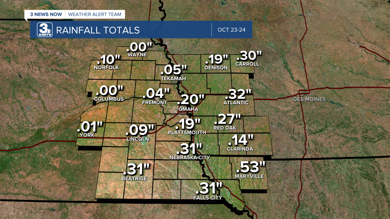
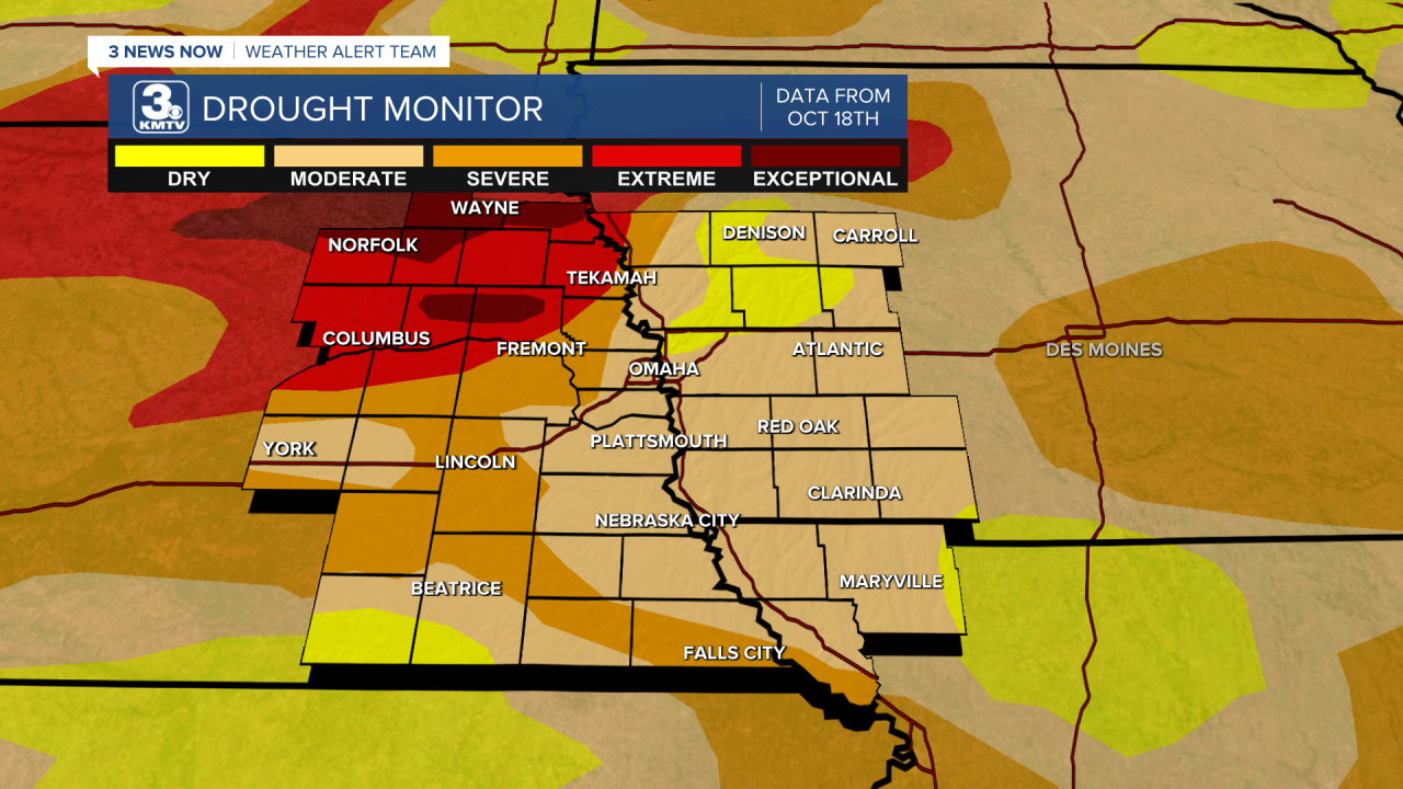
Although welcome, the rain was nowhere near enough to put a dent in the drought. Places which are experiencing the worst of the drought, northeast Nebraska, picked up next to none.
The good news is there is another chance for rain around mid-week! Thankfully, it will not come with all the other hazards experienced on Sunday.
