

So far this year, our severe weather season has been relatively quiet. Coming on the heels of one of the most active severe weather seasons on record, 2024, the 2025 season feels like a breath of fresh air. However, all it takes is one storm, and for those who were awoken Saturday morning, that reality came home.
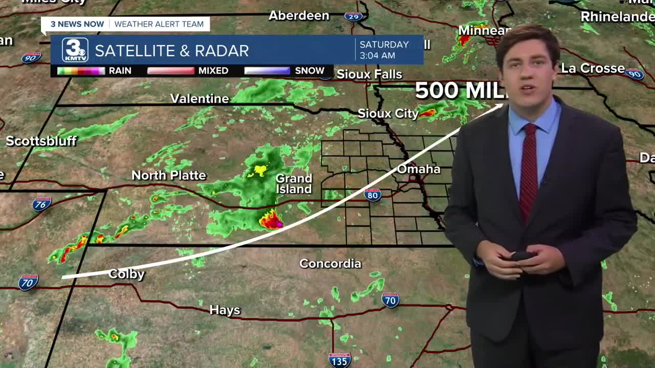
The forecast on Friday did call for thunderstorms, but mostly over northeast Nebraska. Computer models had a difficult time picking up on many storms for Saturday morning, that is, until the late evening. So what changed?
Hundreds of miles away, in eastern Colorado, storms began to develop that computer models missed. Once the data was added, models changed their tune, now bringing a cluster of storms through eastern Nebraska. Yet, this development was not until after 8 pm, when some had already gone to bed. The chance of Saturday morning storms was increased in 10 pm newscasts.
So, for some, the first indication of the storms was either hearing your phone go off, or were awoken by the outdoor warning sirens. Normally, phones do not go off for severe thunderstorm warnings. However, thanks to the great Iowa derecho 5 years ago, some of them will. Whenever a severe thunderstorm warning is considered "destructive", which is defined as 80+ mph winds and/or baseball-sized+ hail, it will set off the wireless emergency alert system.
This will also trigger the outdoor warning siren activation by local Emergency Management Agencies. There were no Tornado Warnings, but the 80 mph winds met the requirement to sound the sirens. They are called Outdoor Warning Sirens, and not Tornado Sirens, for a reason now.
While everyone was asleep, the Colorado storms were moving into a powder keg. Despite it being night, Nebraska and Iowa had lots of atmospheric energy laying around. We measure atmospheric energy by CAPE (Convective Available Potential Energy). A rule of thumb is that any value over 1500 j/kg is sufficient for severe storms. At 4 am over eastern Nebraska, those values were as high as 4000 j/kg!
We can see the power of this storm in the amount of lightning it produced. If you saw the storm, the light show was rave-like with the constant strobe effects. At its height, this storm was producing nearly 2000 lightning strikes in 10 minutes! That's about 3 lightning strikes every second!

The storm also produced copious amounts of rainfall. Some locations saw as much as 4" of rain in under an hour, which also caused some flooding issues.
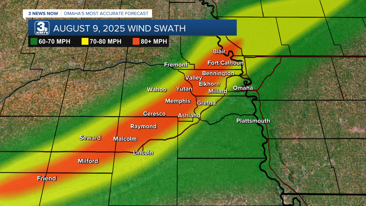
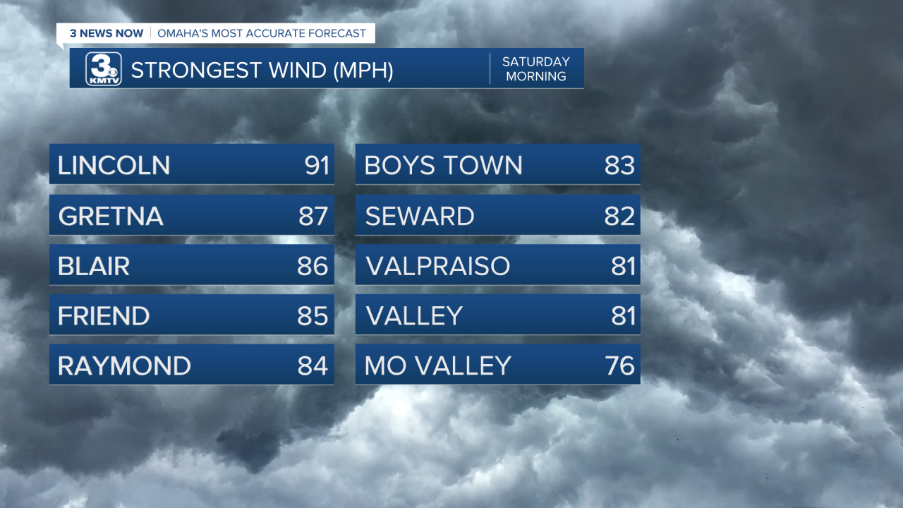
By and far, the story with this storm was the wind. A swath of 80+ mph winds moved from Fillmore County, Nebraska, to Carroll County, Iowa. It caused major tree and structure damage in Seward, Lincoln, northern Lancaster County, eastern Saunders County, western Douglas County, and Washington County. The Lincoln Airport recorded a 91 mph wind gust, and a weather station between Gretna & Elkhorn recorded an 87 mph wind gust.
The damage was extensive, and you can read our coverage of Waterloo and Blair here. Hundreds of trees were snapped, buildings damaged, and one person died at the Two Rivers Campground when a tree fell on their car.
In context, this windstorm will go down as one of the more significant ones in recent memory, on par with the July 31 windstorm in terms of raw damage in spots.
Yet, the weekend was not done. After a dry Saturday, the atmosphere reloaded for a second round of thunderstorms, this time targeting areas south of I-80.
The same powder keg was in place Sunday morning as it was Saturday morning, with 4000 j/kg CAPE in the area. A cluster of storms formed southwest of Kearney and rolled along the Nebraska state line. The winds reached as high as 90 mph.
Damage across southeast Nebraska was more sporadic. Trees & power poles snapped, grain bins destroyed, and sheds lost their roofs in Jefferson, Gage, Johnson, and Otoe Counties. The Nebraska City Airport recorded a 90 mph wind gust before it went offline. Sheds were damaged at the airport.

A more concentrated area of damage began in eastern Fremont County. Riverton & Farragut had extensive tree and some building damage. In Shenandoah, trees were snapped all over town, some buildings had damage, and a semi truck was blown over in the Walmart parking lot. Tragically, according to KMA radio, one person lost their life in Shenandoah due to the storms.

Though more localized, the second windstorm still caused major damage in the communities it hit. It's rare for our area to be hit with 2 windstorms within 24 hours of each other, making the weekend of August 8-9, 2025, one to remember. It only takes one storm.
