
Snow in April is uncommon, but it happens. On average, Omaha has seen 1" of snow in April. This accounts for many April's with no snow, and several April's with multiple inches of snow. If snow is uncommon, blizzards in April are rare, with only a handful occurring since record-keeping began in the 1880s. One of these blizzards was ferocious, on April 10, 1973. Its effects were mostly felt in Iowa, where over a foot of snow fell, and when combined with 65 mph winds it brought snow drifts as high as 16 feet. In this installment of This Week in Weather History, it's one of the worst April blizzards in Iowa history.
THE SET-UP
On average, April is the windiest month for the Midwest. Part of this is due to strong storm systems that bring lots of wind to the region, meaning many storm systems could meet blizzard criteria. However, these storm systems lack one crucial factor, cold air. As the cold air retreats further north into Canada, any storm system that traverses the Midwest does not bring snow, but more often it brings thunderstorms.
There was one exception to this, April 1973. The month was incredibly active for weather, following on the heels of an already active winter. By April, much of the Midwest dealt with significant flooding from heavy rain and snow melt. The flooding was most felt in the Mississippi River, where the river gauge in St. Louis was in flood stage from early March to late May. Other creeks and rivers across Nebraska, Iowa, and Missouri were flooding.

By April 7, a storm system began to move across the Rocky Mountains. Ahead of this, snow started to fall in western Nebraska, with up to 10" falling in parts of the Panhandle. A particularly strong blast of cold Canadian air spilled into the Midwest ahead of this storm system. High temperatures in Nebraska and Iowa hardly reached 30 degrees, and low temperatures dropped into the teens. This cold air allowed precipitation to fall as snow over much of the area.
As the low-pressure system moved over Kansas on April 8, it started to weaken, meaning the snow was lighter over eastern Nebraska. Overnight on April 8, a second area of low pressure developed over eastern Oklahoma. This area of low pressure began to deepen (strengthen) rapidly as it moved into Missouri. As the low deepened, it sucked in all the air around it, creating significant wind gusts over 60 mph across the Midwest. This area of low pressure also had abundant moisture to work with, as it brought up the moisture-laden air from the Gulf of Mexico.

This combination: of cold air, moisture-laden air, and high winds would all come together over Iowa. The result was not only the worst April blizzard on record but one of the worst blizzards in Iowa history.
THE BLIZZARD
The snow began falling late on April 8 but would reach peak intensity on April 9 and last into April 10. Original forecasts called for a few inches of snow, enough to alert Midwesterners in April. There was some preparation in advance of the snow. Traveler advisories were issued, some schools and businesses closed, and government officials began emergency actions.
On the morning of April 9, light snow began to fall across Nebraska and Iowa. It fell so lightly that it started melting on contact. Over eastern Nebraska, the snow picked up by lunchtime, bringing some travel issues to Omaha and surrounding areas. The evening commute was slow as Omaha picked up 2" of snow, which was blown around by the high winds. US-75 between Blair and Fort Calhoun was closed for up to 11 hours due to the blowing snow and high winds. By April 10, the melting process began in Omaha, and most snow would disappear by the 12th.
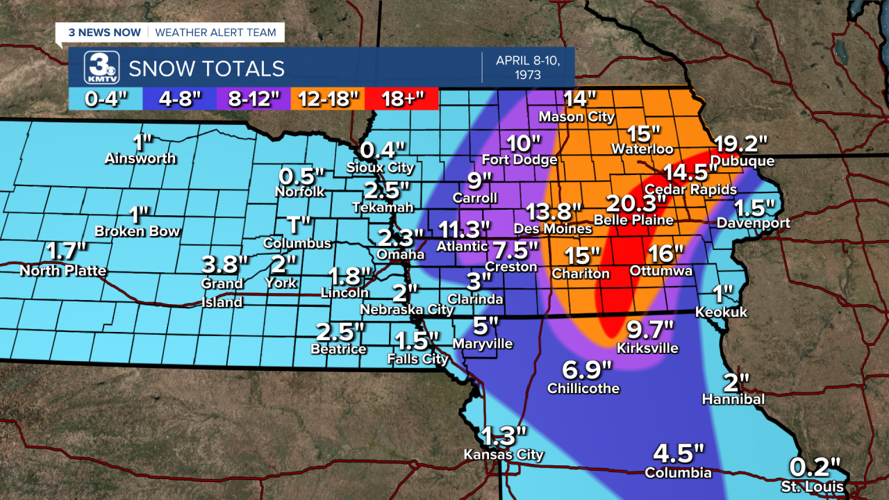
It was a different story in Iowa, where the heavy snow caused major problems. The snow fell in heavy bands with rates up to 2" an hour. The wind cranked from the north, occasionally reaching above 65 mph. In southwest Iowa, emergency crews were overwhelmed by the number of accidents on rural roads. As one car accident was cleaned up, 3 others would occur. Estimates place the number of single-car or multiple-car accidents to be around 100 in Pottawattamie, Mills, Fremont, Page, Montgomery, Cass, Shelby, Audubon, and Carroll Counties. Snowfall ranged from just 3" in Clarinda to over 11" in Atlantic. Near Harlan, a patrol officer was helping one accident when his vehicle was struck by another car, no one was injured.

In Des Moines, where over 13" of snow fell. Thousands of motorists abandoned their cars across the Des Moines metro, many of them being left in the streets. Stranded people found shelter where they could: hotels, stores, schools, and other's homes. That evening, the mayor of Des Moines issued a statement calling for the city to shut down for the next day. Due to the high winds, several thousand customers in Des Moines lost power, some for many hours.

In eastern Iowa, the snow accumulated even higher. Some spots in eastern Iowa received as much as 20 inches of snow. In Dubuque, it looked like a ghost town as businesses closed throughout town, and up to 19" of snow fell in the city. Combined with the winds over 50 mph, there were drifts in eastern Iowa up to 16 feet tall! The region was paralyzed, the worst snowstorm in eastern Iowa history until the blizzard of January 1979.
Overall, the losses were greatest in their human and livestock toll. 14 Iowans died in the blizzard, most from heart attacks or traffic accidents. 1 person was killed in northern Missouri, where blizzard conditions were also felt. In terms of livestock, many were stranded in the deep snowdrifts. It is estimated that agriculture losses were in the tens of millions, mostly due to cattle. In Missouri, 12,000 four-pound turkeys were killed near Kirksville, not too far from the Iowa state line. The heavy wet snow also meant that when it melted, it sent 2-3" of liquid water into already swollen creeks, exacerbating the flooding already going on. As of April 1973 was not already active, between April 18-20 a tornado outbreak impacted parts of Missouri and Iowa. The majority of the tornadoes were in Missouri. Near Kirksville, where nearly a foot of snow fell, an F-4 tornado damaged homes and killed one person. It was truly a month to be remembered, all bounded by the blizzard of April 9.
