


When you think of Nebraska tornadoes, what comes to mind? Is it the Omaha tornado of 1975? The "Night of the Twisters" in Grand Island in 1980? The Hallam Tornado? Alongside those famous ones, there is another more recent tornado outbreak that might have popped up, the Pilger tornadoes of 2014.
On the afternoon of June 16, 2014, four violent tornadoes tore paths across Stanton, Cuming, and Wayne Counties. The event is most famous in the meteorology world for its famed "twin tornadoes" which is almost unheard of. One supercell was responsible for spawning four violent tornadoes, oftentimes alongside one another.
For the residents of Pilger and the surrounding countryside, June 16 2014 won't be a day soon forgotten. So, in this installment of This Week in Weather History, we go to the recent past to look back at the tornado swarm around Pilger.
PILGER: A HISTORY AND LAYOUT
In 1874, John Peter Pilger purchased 160 acres of land in eastern Stanton County along the Elkhorn River and along the conjunction with Humbug Creek. Pilger owned the land for five years before selling it in 1879 to the Fremont, Elkhorn, and Missouri Valley railroad. A depot was established in September 1879, and slowly the settlement began around it. The town was known as "Canton" until it the post office was established in July 1884, naming the community after its founder, Pilger. The village of Pilger became incorporated in 1887. In 2014, Pilger was 127 years old, and boasted a population of 352 as of the 2010 census.

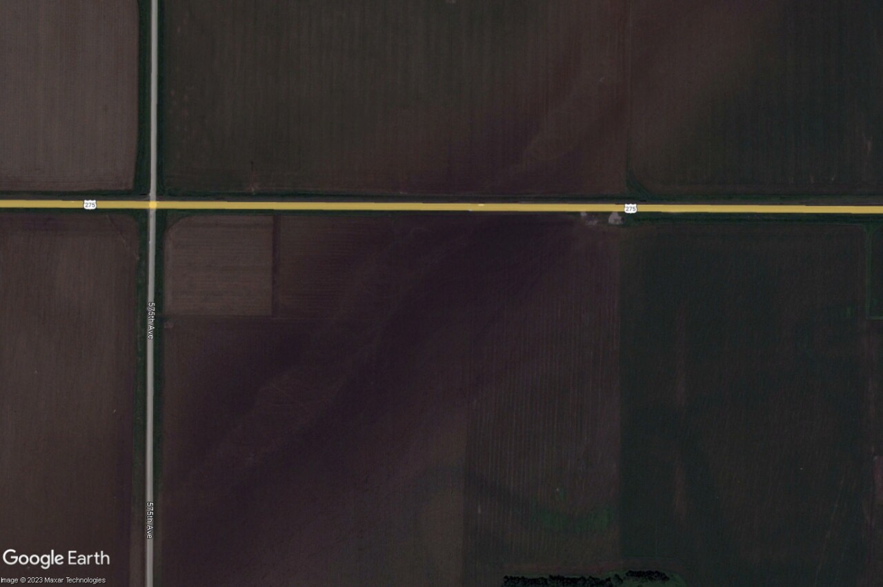
Pilger is roughly a 90-minute drive from Omaha. Located in Stanton County, Pilger is one of two communities in the county, the other being the county seat of Stanton. Pilger sits a half mile south of the intersection of Nebraska Highway 15 and US Highway 275. Highway 15 runs along the west side of town, the main route to get to the nearby towns of Stanton and Wisner along Highway 275.

JUNE 16, 2014: THE SET-UP
Pilger and northeast Nebraska are not strangers to tornadoes or severe weather. Older generations of the Pilger area remember when a tornado swept through the nearby countryside on June 17, 1954. More recently, the region had a near miss when an EF-4 tornado struck Wayne on October 4, 2013. Just two weeks prior to June 16th, on June 3rd, baseball size hail alongside 70mph winds caused substantial damage in Stanton and Cuming Counties. When the tornadoes went through on June 16, many residents had just repaired roofs, siding, and windows due to the hail.
June 16 was prime for severe weather, including tornadoes. That morning, a cluster of storms moved through eastern Nebraska ahead of a warm front. These storms dropped very large hail north of Lincoln and in the Omaha metro, where hail upwards of 2" was reported. Once they passed through that morning, they left an atmosphere unstable.

At the National Weather Service office in Omaha, a special weather balloon was launched at 1 p.m. to attempt to get a sample of the atmosphere. The data it brought back worried them greatly. "Oh my..." was the response of one of the meteorologists to the weather balloon data. Most of the parameters for severe weather were off the charts for northeastern Nebraska.

The "supercell composite" is a parameter used by forecasters that takes in data from several ingredients to show a number. Generally, any value over three is sufficient for supercells, with numbers anywhere between 10-30 very conducive. The supercell composite parameter was in the 40s, with some values as high as 60!

Likewise, the "Significant Tornado Parameter" is another product used to assess the atmosphere for the capability of producing significant tornadoes (greater than EF-2). Anything over one is deemed sufficient, but on June 16 the values were over 10.
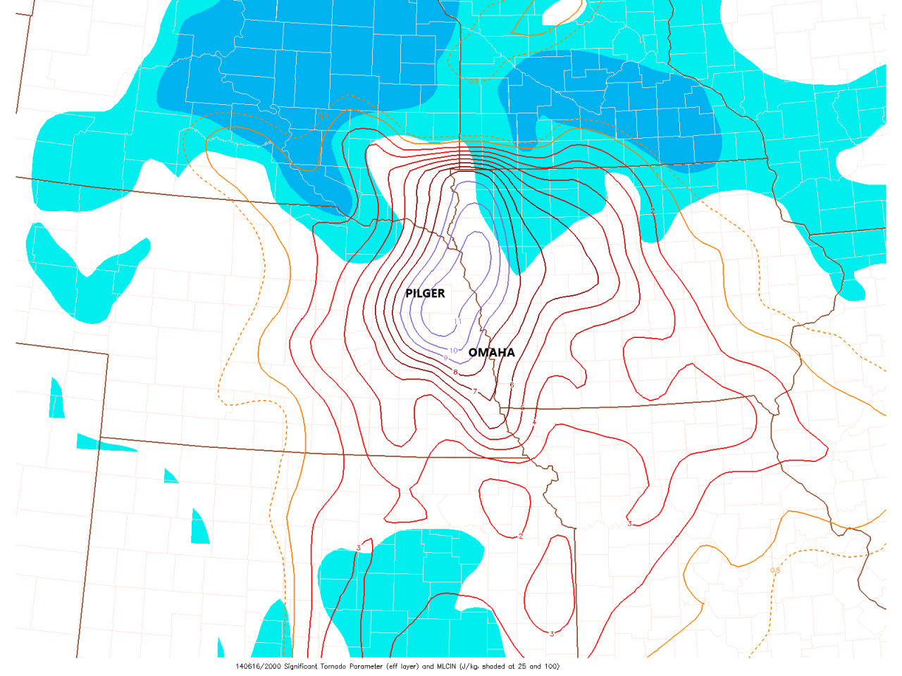
Due to the severe weather environment being prime, the forecasters at the Storm Prediction Center issued strong wording which focused on northeast Nebraska. In their severe weather outlook, they said:
Tornado threat appears to be increasing across portions of Nebraska ... several significant tornadoes and/or a violent tornado can not be ruled out.

As things evolved, a Tornado Watch was issued. However, it was not just any watch, but a Particularly Dangerous Situation tornado watch. A PDS tornado watch, for short, is rarely issued where the ingredients for a strong tornado appear likely. To put this in context, a PDS tornado watch has not been issued for eastern Nebraska or western Iowa since then.

OVERVIEW
As the Tornado Watch was being issued, one lone supercell thunderstorm developed over Platte and Madison Counties. It quickly went severe, producing 1" hail in Madison. Then as the storm crossed into Stanton County, it became tornadic. The next two hours saw the tornado drop not one, not two, not three, but four violent tornadoes in a short span of time.

The storm produced five tornadoes, four of which were violent. They are named in this article as the Stanton Tornado (Tornado #1), the Pilger Tornado (Tornado #2), the Pilger East/Wisner Tornado (Tornado #3), and the Wakefield Tornado (Tornado #4). The fifth tornado was a brief EF-0 east of Madison.


Pilger is most famous for the "twin tornadoes" that it produced. Although one storm producing multiple tornadoes at once is not uncommon, typically there is one strong tornado and one weak one, known as a "satellite tornado." What made Pilger unique was both tornadoes were separate from one another and both were violent, something that has hardly ever, if at all, been documented.


TORNADO #1: STANTON EF-4

After producing a weak EF-0 east of Madison, the first violent tornado of the day touched down southwest of Stanton. The tornado originally did weaker damage to trees and powerlines southwest of Stanton. It's only when the tornado crosses over Highway 24, just two miles west of the county seat, that it creates its first area of significant damage. It was there that a group of farmsteads suffered significant damage from the tornado, although no one inside was hurt.
The tornado then skimmed past Lake Maskenthine, north of Stanton, ever-increasing in its intensity. As the tornado approached Highway 275, it demolished its first home. Nothing but the basement remained of the home, but the occupants taking shelter were unharmed.

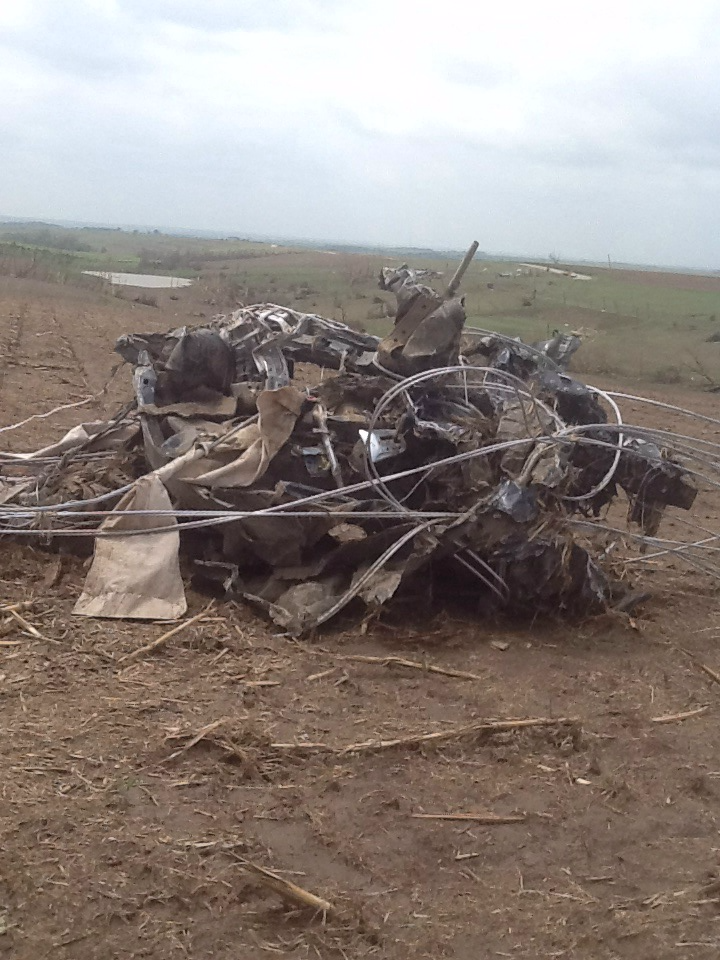
The two vehicles at the home, one car and one truck were lofted by the tornado. The car sailed over a quarter mile before landing in a crumpled heap. The property where the car originated, sits in the distant background.
The tornado barrelled across Highway 275, inflicting complete destruction on two more homes north of the highway. Like the previous home, only the basement remained. The residents in the homes took shelter in their basements and all survived uninjured as the tornado roped out a short distance from the homes.

WATCH: Life-cycle of the Stanton Tornado, by Storm Chaser Tony Laubach
TORNADO #2: PILGER EF-4

As storm chasers watched the Stanton tornado lift north of Highway 275, their attention was immediately focused to the east as a new area of rotation began forming just east of Stanton. Within minutes, another tornado touched down, this time east of Stanton. The tornado first took aim at the gravel pit and lake southwest of Pilger, where the flower shop was destroyed. One man rode out the storm in a barge on the lake, and was unhurt. The tornado grazed by a new housing development on the lake and continued northeastward towards Pilger.
Storm chasers watched in horror as the tornado smashed into Pilger. Videos of the tornado show the Pilger water tower loom ominously as debris gets torn up in tornadoes. Those watching the chaser livestreams, the Weather Channel, or local news saw Pilger get hit in real-time. For the residents of town, it was 81 seconds they would never forget.

Pilger Fire Chief Kory Koehlmoos was about ready to leave Pilger for Stanton when the call came out for assistance for the Stanton tornado victims. Right as he was leaving town, he noticed a funnel cloud heading for Pilger. Power was out in town, so the outdoor warning siren was not sounding, it needed to be activated manually. He turned back around, risking his life, and turned on the siren. People who were originally outside watching the storm began moving for shelter in town as the tornado approached. The sound of the siren continued to wail before abruptly cutting off as the tornado destroyed it.
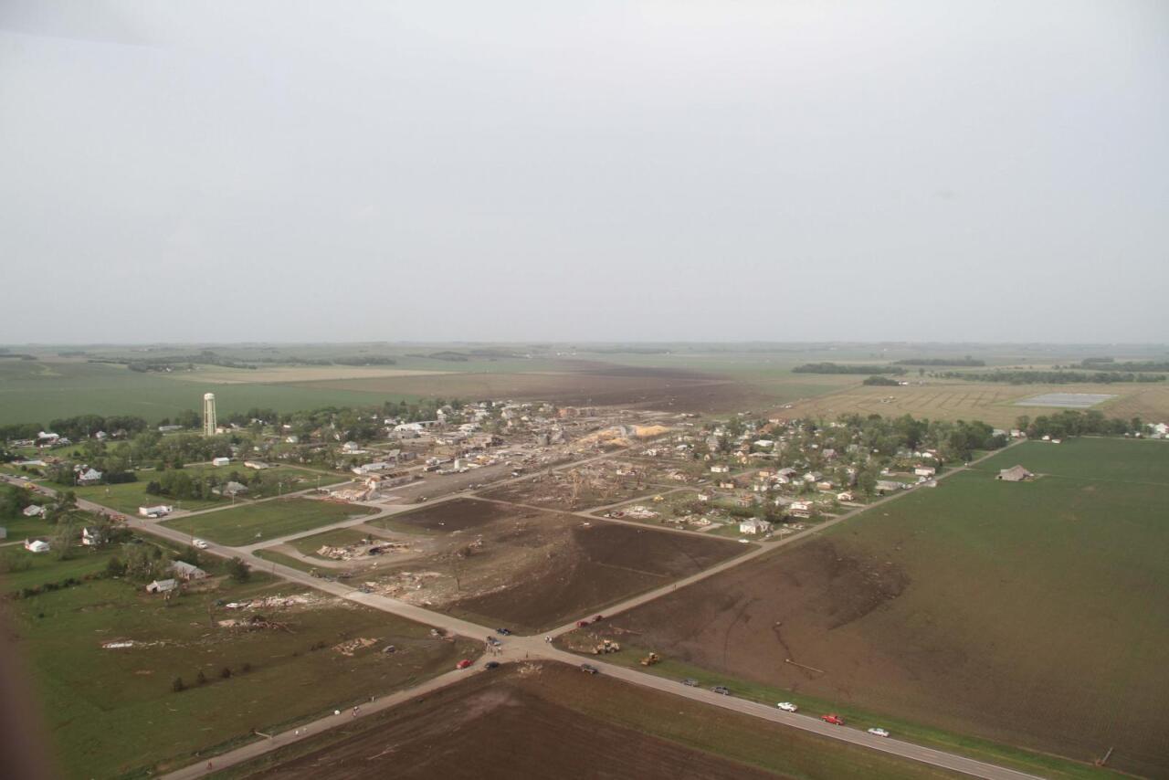
The tornado entered the southwest side of Pilger, where a feed store and an RV were completely destroyed. As the tornado moved into the block of homes along Elm Street. It did violent EF-4 damage wiping many homes completely off of their foundations.


North of Elm St sits the Farmers Co-op building, alongside the Pilger Store. Several people were in the Pilger store when the sirens sounded and got into the cooler of the store. After hearing a loud pop they realized the roof went, as is shown in security camera footage. They hunkered down in the cooler until the tornado passed. The Pilger Store had suffered intense damage. The grain bins which sit in the center of town were crumpled and destroyed, the contents of them sitting in huge piles in the center of town.


To the north of the Pilger Store is Main Street, where the business district of Pilger lies. On the southwest corner of the district sits Midwest Bank. Bank President Gene Willers was paying attention to the weather that afternoon, and when he heard the alarms he ushered his employees into the bank vault. After a robbery of the bank in 1998, air-holes were drilled in along with a pre-paid cell phone. Willers remained outside the vault to open it once the tornado passed and took shelter in the crawlspace of the bank. The tornado hit the bank, causing significant damage. Willers, uninjured, went up to release the also uninjured occupants from the vault. After a brief scare with a second tornado forcing them to take shelter again, all the bank employees were okay.

Up Main Street, every building lost roofs and a significant part of their second stories with the exception of the library. Those inside the buildings were largely uninjured.

Tragically, it was across the street where the Pilger tornado took its one and only life in town. A trailer sat on Main Street, home to a mother and her two children. The three attempted to run across the street to safety when the tornado hit, throwing the three in all directions. The mother suffered extensive injuries. Her 5-year-old daughter, Calista Dixon, was killed.
The tornado passed the business district continuing to the northeast. The heart of the tornado tore down Second Street, where the other area with the most significant damage occurred to homes and other structures.
Homes were wiped off their foundations, leaving only basements or slabs remaining. It is estimated wind speeds exceeded 190 mph — a high-end EF-4 tornado. Many of the homes in Pilger were unanchored, weighed down by gravity. Had those homes been anchored and still blown away, the Pilger tornado would have been an EF-5. It is important to note that the rating of the Pilger tornado was at least EF-4, suggesting it potentially could have seen winds peak over 200mph, EF-5 intensity.

Before leaving town, the tornado took aim at two large buildings on the east side of town. The first building was the Pilger-Wisner Middle School, which was unoccupied as it was summer break. Substantial roof and building damage was done, perhaps done by one of the grain bins smashing into the school. The damage at the school was so significant it had to be torn down. It was not rebuilt and all schools in the district are located in Wisner.
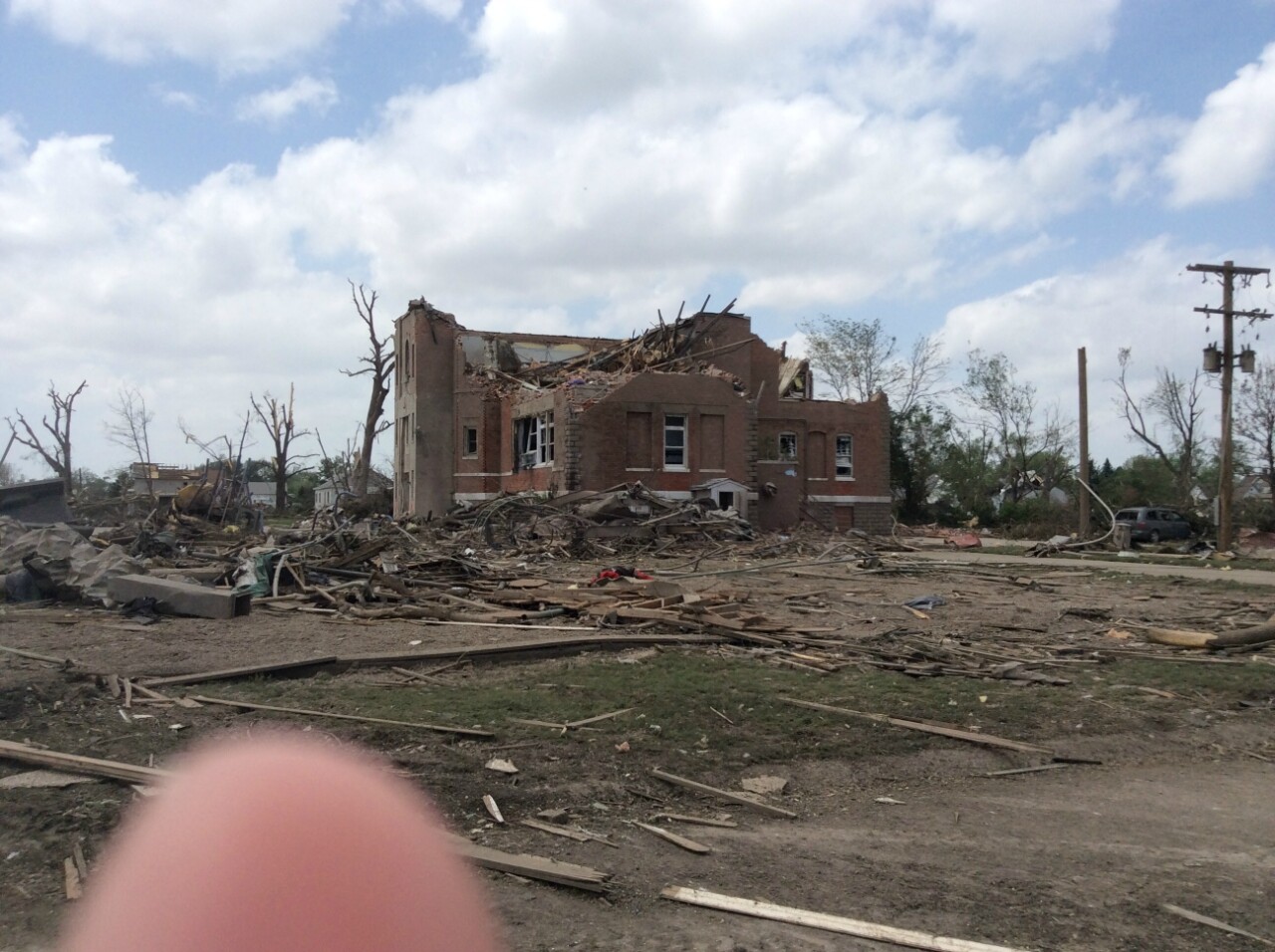
The final building destroyed in Pilger is perhaps the most poignant, the St. Johns Lutheran Church. There were a few people taking shelter inside, and all watched as the entire church was lifted away and destroyed. Those inside suffered some injuries, but all survived. The only structure remaining with the church was the bell tower, which still stands today.

Finally, after 81 seconds, the tornado left Pilger. With the exception of the northwest and southeast corner, much of Pilger was damaged, if not destroyed. It is estimated around 75% of the village suffered some sort of damage. Among the structures still standing include the water tower, the baseball field, and the community pool which all were in the northwest part of town. One person in Pilger was dead, and around 20 were injured.

The tornado did not quit at Pilger, it continued to charge northeast out of town into the fields nearby. At this point, it was on the ground alongside its twin to the east as the tornadoes crossed Highway 275.
The tornado continued to wreak havoc into northwest Cuming County and ultimately into Wayne County. The tornado crossed with its eastern twin north of Wisner before emerging into Wayne County.


The Pilger life cycle ends where the Wakefield EF-4 (tornado 4) begins, but before it dies it achieves an astonishing feat. Becoming a rope tornado; it got caught in the mechanisms of the new violent tornado and accelerated. Scientists examining the video of the tornado show it may have sped up to 94 mph before dissipating. If it achieved this speed, it is possibly the fastest tornado on record, although the record is not official.
VIDEOS: Ben McMillian, Scott Peake, Pecos Hank
TORNADO #3: PILGER EAST/WISNER EF-4

As the Pilger tornado tore through town, storm chasers observed a second funnel cloud developing southeast of Pilger. Originally not thinking much of it, the second funnel quickly touched down and became a second violent tornado as it crossed into Cuming County. It crossed Highway 275 just a minute after the Pilger tornado, the third tornado to do so of the day.

As it moved west of Wisner, the third tornado began to intensify before crossing in front of the Pilger tornado. As it did, it completely leveled a home northwest of Wisner, only leaving some structures remaining. It was at this point, a few minutes later, the Pilger tornado crossed the same path making an X and damaging other areas. The owner of the home took shelter in his basement as the Wisner tornado hit, then had to run to his cellar as his basement was damaged when the Pilger tornado hit a few minutes later. The homeowner survived uninjured.

After crossing in front of the tornado, the Wisner tornado then began to curve to the northwest in Wayne County as the Pilger tornado moved to its south. This almost carousel-like movement of the tornadoes is known as the Fujiwara effect. Shortly after, the Wisner tornado lifted.

Unfortunately, the Wisner tornado also took the second and final life of the day. Seventy-four-year-old David Herout, a Clarkson resident, was making deliveries in Cuming County when his car was lifted and thrown by the tornado.
VIDEO: Timothy Klaustermeier
TORNADO #4: WAKEFIELD EF-4

As mentioned above, the Pilger tornado accelerated to over 90 mph as it was sucked into the outer circulation of the fourth and final tornado of the event, the Wakefield EF-4.

This tornado took an unusual direction in that it went due north through eastern Wayne County, paralleling Highway 16 before crossing into Dixon County just a few miles east of Wakefield. Wakefield was also narrowly missed to the west by the Wayne EF-4 just nine months before, two near-misses in under a year.

The Wakefield tornado produced minor to moderate damage until it got to a four-home corner in eastern Wayne County. There, it leveled all four homes down to their foundations. No one was seriously hurt, and this was to be the worst damage of the entire tornado track.

Crossing into Dixon County, the tornado damaged a few more homes. One of these homes had a young man inside of it who was thrown from the home, suffered injuries, but survived.
VIDEO: Skip Talbot
AFTERMATH
After the Wakefield tornado lifted, storm chasers report a few other brief tornado touchdowns in Thurston and Dakota Counties, but as the storm approached Sioux City it weakened and disappeared.
Back to the west, a second supercell developed over central Nebraska northeast of North Platte. This storm dropped a few photogenic tornadoes near Burwell, the strongest of which being rated an EF-2.
Northeast Nebraska was not done with violent weather yet. The very next day, June 17, a supercell developed north of Wayne and dropped several large tornadoes outside of the towns of Coleridge and Laurel. These impacted mostly rural areas, and no one was injured or killed. Three days later on June 20, flash flooding in the Omaha metro led to one fatality, raising the death toll in Nebraska from the June 2014 storms to three.

In the immediate aftermath of the tornadoes of June 16, dozens to hundreds of people flocked to Pilger and the surrounding areas to begin assistance of rescue efforts. Those who needed to be transported to nearby hospitals went, and others began salvaging what was left of their lives. The governor declared a state of emergency for the storms, and the federal government declared parts of Nebraska a disaster area which allowed for more assistance.

In the following weeks, thousands of volunteers poured into the region to help in any way they could. These volunteers came from across the country, and even internationally to assist those in need. Relief efforts were organized by Churches, charities, and other groups to assist. A year after the tornado, there was still a long way to go, but the major first steps occurred.

Today, Pilger is a community that has come a long way, but the scars remain. Empty fields exist where homes once stood. One can stand at Midwest Bank and have a clear view of St. Johns Lutheran Church, which you used to not be able to see pre-2014.

There are signs the village is coming back. New homes have been built, and plots of land are for sale waiting for someone to purchase. The Pilger Store was rebuilt to become the Pilger PRIDE store now off of Highway 15.

However, the road to recovery was a bumpy one. In the years following the tornado, the residents of Pilger rode through a financial scandal involving one of the heroes of the recovery, village clerk Kim Nieman. In charge of village finances, including after the tornado, she was arrested in 2020 for mishandling the funds after the tornado. Although her motives are still somewhat unclear, the charges claim she used roughly $700,000 of village money for other expenses.

Despite this, Pilger is a community looking toward the future. Many residents have left for other towns, as reflected in the census drop from 352 in 2010 to 240 in 2020. In the countryside, its much of the same — residents either rebuilt or moved. The scars of June 16, 2014 resonate in the region to this day and will for a long time after.
SOURCES
Most of the research is from the book "Eighty-One Seconds: The Attack and Aftermath as Tornadoes Hit Pilger, Stanton, Wakefield and Wisner, Nebraska" written by LaRayne M. Topp. The book contains many more personal accounts of the tornado and the recovery. Other sources include the National Weather Service in Omaha, and multiple newspapers including the Omaha World-Herald, Lincoln Journal-Star, Norfolk Daily News, Stanton Register, and the Wisner News-Chronicle. Alongside personal interviews with survivors.
