


Severe thunderstorms carry a variety of hazards with them. The five core dangers of a severe thunderstorm are frequent lightning, heavy rainfall, large hail, damaging winds, and tornadoes. We tend to focus on the most destructive storms, which are the ones that produce tornadoes. However, destructive thunderstorms can occur when producing large hail and damaging winds alone.
On June 3, 2014, we truly had it all. A destructive severe weather outbreak swept through Nebraska and Iowa. Several waves of powerful thunderstorms raked over the landscape. The most severe of these storms moved from northeast Nebraska into southwest Iowa, producing hail up to 4" in diameter and 90 mph winds, hitting the town of Blair particularly hard. Other storms that day produced a tornado near Oakland, IA, and major flooding in the Omaha metro. In this installment of This Week in Weather History, we look at the major severe weather outbreak 10 years ago.
THE SET-UP
Hints that a possible severe weather event was noticed by meteorologists as early as May 31, four days before the outbreak. However, the storms on Tuesday (June 3) took a backseat to the possibility of severe weather that Sunday (June 1). That afternoon, severe weather moved through Omaha with 60 mph winds. The day was remembered for wrecking the Taste of Omaha fairgrounds before the event began, throwing tents and barriers around like toys.
On Sunday, most of eastern Nebraska and western Iowa were outlined in the equivalent of a level 3/5 severe risk, which is not common that far out. A warm front would be moving northward that afternoon into eastern Nebraska. Near and south of the warm front, a volatile environment for severe weather was in place with a very unstable air mass overlaid with strong wind shear. The ingredients for significant tornadoes and damaging winds were in place, and the stage for a potential tornado outbreak was in place.

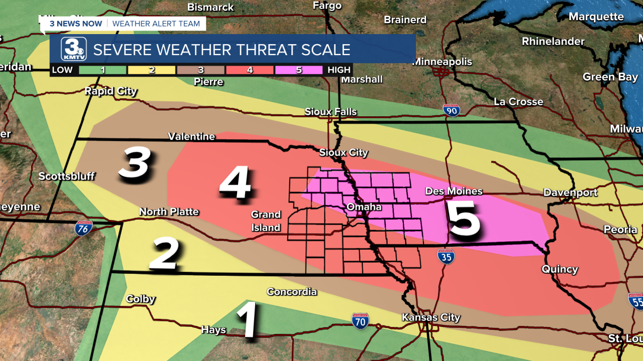
By June 2, a large level 4/5 risk was issued, including most of Nebraska and Iowa. The possibility for several tornadoes, very large hail, and significant damaging winds were all in the forecast. This 4/5 risk was maintained into the morning of June 3, it was about to be a very active day for severe weather in Nebraska and Iowa.
That afternoon, the atmosphere became so volatile that the Storm Prediction Center took a rare step, and issued a level 5/5 severe weather risk for Nebraska and Iowa. As of writing this article in June 2024, this is the last level 5/5 risk for the area, making it 10 years since we have seen a severe weather risk so significant.
THE STORMS

Around 9 am, a cluster of thunderstorms developed along the warm front in southern South Dakota. No one would know it at the time, but this cluster of storms would be the one to bring most of the severe weather to the region. It intensified as it crossed into Nebraska near Valentine, it would move southeast paralleling Highway 20 over northern Nebraska. It produced golf ball-sized hail and 70 mph winds as it moved over the area. As the storm approached O'Neill, the Storm Prediction Center issued a Tornado Watch ahead of it for most of eastern Nebraska and western Iowa at 1:15 pm, right as the storm approached Norfolk.
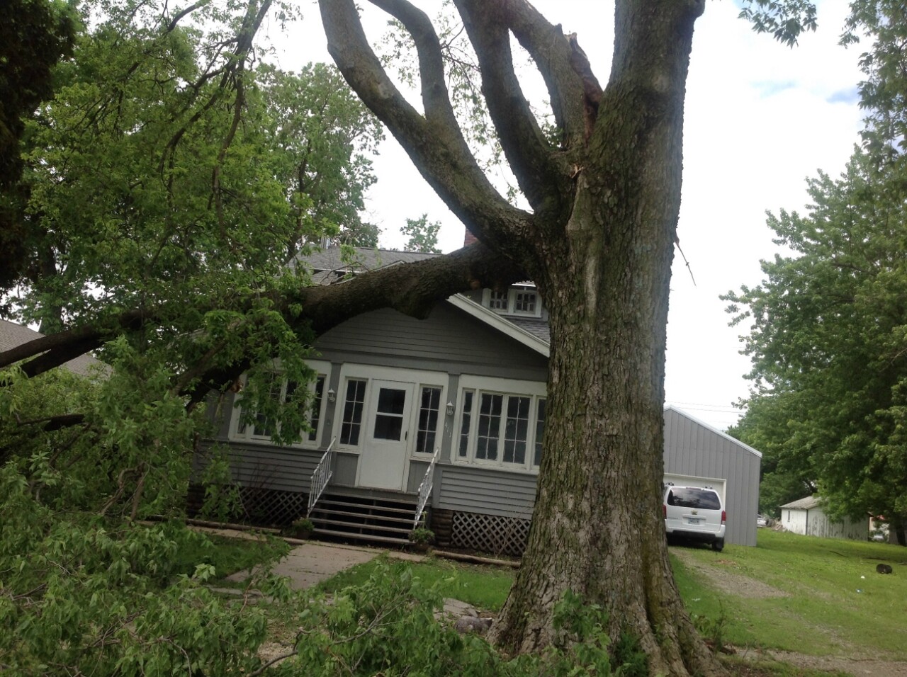
As the storm hit Norfolk, the hail size increased to baseball size hail alongside 70 mph winds as the storm hit town. The storm damaged vehicles, siding, and smashed windows in Norfolk. The storm also caused significant damage in Stanton County, where major roof damage occurred in Stanton proper from the storms. This would be ominous as not even two weeks later, Stanton County would become ground zero for the June 16 Pilger tornado outbreak. The storm crossed into Cuming County, where golf ball size hail and 70 mph winds caused more damage.

As the storm moved through Dodge, Burt, and Washington Counties it began changing character. The hail size increased to over 2", and the wind gusts topped out at 80-90 mph. Across the three counties, the damage was as significant as a tornado. Many outbuildings were destroyed, trees snapped, and homes damaged from the winds alone. Combine the 90 mph wind with baseball-sized hail, and the storm became a shredder as it hit Uehling, Craig, Kennard, and Herman.

Right in the crosshairs of the storm was Blair, where the worst damage out of any storm occurred. Baseball size hail alongside the 90 mph wind gusts pelted the town, turning the community into a war zone. Homes looked like Swiss cheese with the amount of holes punched into the siding. Almost every home and building had some sort of damage, whether it was from smashed windows, holes in the siding, or other damage. The most poignant example of damage in Blair was at Woodhouse Auto, where every one of the 4,500 cars had some sort of damage. It took weeks to clean up and begin repairs for Blair, it was the most destructive thunderstorm in the city's history.

After leaving Blair, the storm dove for the northern Omaha metro. While the core of the metro was missed, large hail fell over North Omaha, Carter Lake, Eppley Airfield, and Council Bluffs. Similar to the hailstorm that occurred in August 2011, the hail caused damage in the aforementioned areas.
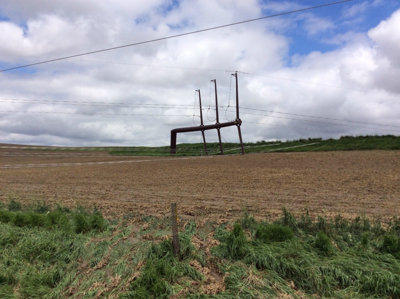
As the storm crossed into western Iowa, it transitioned from a very large hail producer to a damaging wind producer. In Pottawattamie County, winds estimated at 115 mph snapped several metal power poles northwest of Oakland.
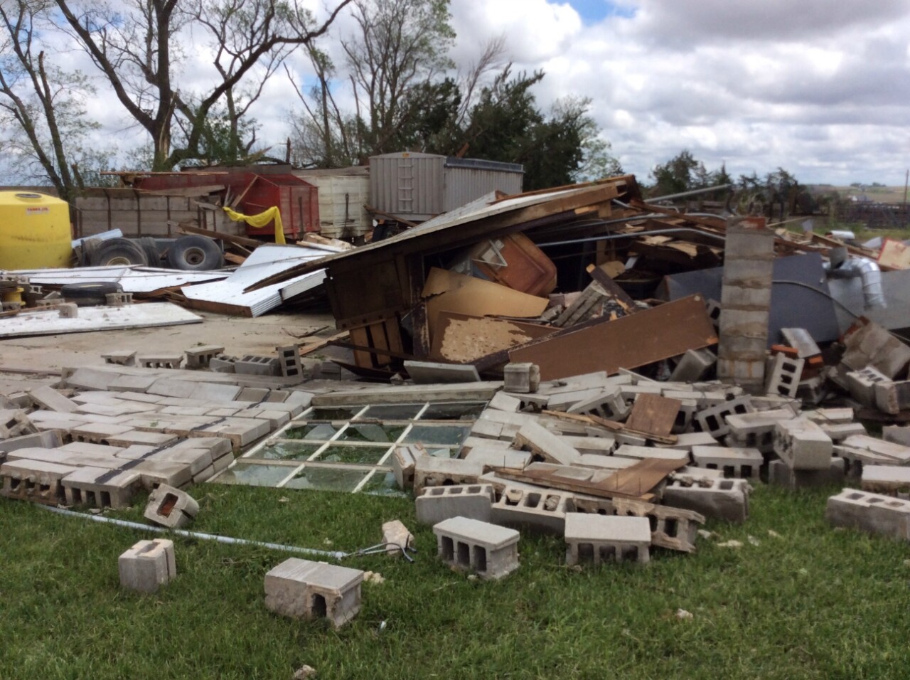
Just west of Oakland, the storm produced its only tornado, an EF-2, that destroyed several outbuildings and grain bins.
High winds continued into Montgomery and Taylor Counties, where wind gusts between 60-80 mph were reported. In Clearfield, in Taylor County, winds estimated up to 80 mph caused significant damage in town.
The storm continued into southern Iowa and northern Missouri, it dissipated in Illinois. The storm traveled from South Dakota to Illinois, which officially classifies the storm as a derecho. The storm that impacted Blair was the most severe storm of the day, and this storm alone produced damage of over 1 billion dollars, which makes it one of the most destructive thunderstorms in recent US history.
The Blair hailstorm was not the only storm of the day, there would be more. The storm produced what is known as an outflow boundary, a boundary of rain-cooled air expelled from a thunderstorm. This outflow boundary sent the warm front careening south through Nebraska, which tempered the tornado threat significantly. In a day when a tornado outbreak was expected in Nebraska, only a few weak tornadoes occurred in central Nebraska, this was due to the influence of the first storm. However, this just meant that every storm in Nebraska that day would produce very large hail and significant damaging winds.

Before the Blair Hailstorm moved into Iowa, a lone supercell developed near Nebraska City. This storm would follow along the Missouri/Iowa border, and produce 2.5" hail in Page County. Damage was done in communities such as Braddyville and Siam in southwest Iowa. This storm would merge with the Blair hailstorm near Lamoni.
Back to the northwest, a storm formed near Ord and moved southwest, passing just south of Columbus. The storm produced 2.5" hail in the Genoa vicinity, smashing several car windows. The storm then produced another swath of 2" hail in Butler, Saunders, and Cass Counties. Damage was done to multiple homes in the Weston area, including the windshield of a Saunders County Sheriff. A few cars driving along I-80 near Greenwood had hail damage as the storm passed overhead. It continued to produce damage in the Nebraska City vicinity, then into northwest Missouri.
The final significant storm in eastern Nebraska began near Grand Island and moved over York, where golf ball size hail damaged homes and vehicles. The storm produced major damage in Saline County in the towns of Crete, Dorchester, and Wilber. In Beatrice, windows were blown out due to the hail. This storm formed into a line of severe storms with high winds in Falls City, and even an EF-3 tornado in far northeast Kansas just a few miles south of the Nebraska border.
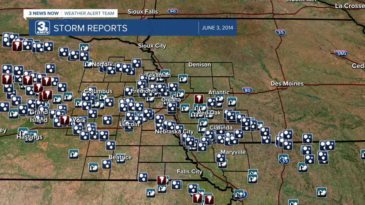
When it was all said and done, the KMTV region had over 100 severe weather reports, most of them hail. It would be the most widespread hail event in the history of the region, with nearly every county having some major hail damage. The storms were so significant they affected the crop yield that year, as many farms had their crops shredded by the storm. It took months for the region to fully recover from the storms of June 3.
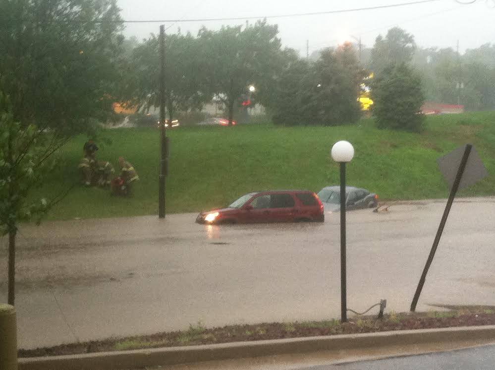
Although Omaha missed the core of the hail frenzy, the metro did not escape the storms entirely. The storms trained over Omaha, producing hours of heavy rain. Eppley Airfield recorded an eye-popping 5.30" of rain on June 3 alone, the 7th wettest day in the city's history (records go back to 1871). The result was major flash flooding across the entire metro. Floodwaters threatened Eppley Airfield, forcing the airport to close for several hours. Roadways were covered in Omaha and Council Bluffs, leading to several water rescues. The most dramatic water rescue occurred on Saddle Creek Road near Dodge, where several people were pulled out of their vehicles. The flooding was the worst seen in the Omaha metro for several years.
When taken into account, the severe weather outbreak of June 3, 2014, remains one of the most historic in the history of the region. Overshadowed by the tragedy in Pilger two weeks later, the outbreak of June 3 deserves its rightful place as one of the most high-end severe weather events in the history of Nebraska and Iowa.
