


If you live in Omaha, think of the most impactful snowstorm you remember. This question depends on when you were born, but if you were born before 1990 there is a good chance the snowstorm of October 1997 came to mind (and not just because it's the subject of this article). One can argue the most impactful winter weather event in Omaha occurred on Oct. 25-26, 1997. It altered the landscape and left a lasting impression on the city. In this installment of This Week in Weather History, we look at the "Tree Shredder" snowstorm of October 1997.
THE WEATHER SET-UP
Snowstorms in October across the Midwest are rare, but they have occurred. Early records show October snows happened in the late 19th into the 20th century, but until the 1990s there was no record of any significant blizzards. On Halloween in 1991, a blizzard dumped up to 2" of snow in Minnesota and canceled Halloween in Omaha. On Oct. 22, 1996, a snowstorm brought 9" of snow to parts of southeast Nebraska. In recent memory, in 2009 almost 6" of snow fell in the Omaha metro. In 2013, the same system that produced the Wayne Tornado 2013 also brought a major blizzard in the Nebraska panhandle and South Dakota.
But the October 1997 snowstorm is special.
The ingredients for the October 1997 snowstorm were two-fold, the first was an arctic cold front that was moving southward over the northern US. This front brought behind it very cold air for late October. This front stalled over Nebraska beginning on Oct. 24, and only slowly moved south over the next few days. The temperatures across eastern Nebraska during this event — thanks to that cold front — are crucial as to what unfolded. Out west, a large storm system took shape over Colorado on Oct. 24. This storm system was slow-moving, making its way to Oklahoma by Oct. 25, and into Missouri on Oct. 26. This placed Nebraska and Iowa in the prime location for the snowfall band to set up.


RECIPE FOR A DISASTER
What made the snowstorm of October 1997 so disastrous? The factors involved include snow amount, the nature of the snow, and the trees themselves.
Amount of Snow: Forecasts leading up to the 1997 snowstorm called for 2-4" of snow for both Omaha and Lincoln. However, both cities ended up with over four times that amount! How did that happen? 1.) The amount of moisture in the storm system was impressive by late October standards, with lots of water content in the atmosphere once it froze it came down as snow. 2.) The location of the front forced the air upward into the region favorable for snow development, which just so happened to be I-80. These smaller-scale features shown below are why the snow band was so narrow, Fremont picked up 3" of snow while Waterloo saw a foot!
Type of Snow: The amount of snow was huge, but so was the heavy nature of the snow. This was because temperatures at the surface during the heaviest snow were near or just above freezing. As the snow fell, right before it reached the ground it melted just enough where it became wet and heavy. The weight of the snow would be unbearable on even the strongest of trees, but a third factor turned this into a true disaster.
The Trees: Because this snowstorm occurred in late October, many of the trees still had the majority of their leaves. Since the leaves act as nets to grab snow, they put more weight on the trees that many could not handle. Many limbs would give way on to homes, cars, and power lines.
These three factors combined for one of the worst snowstorms in Nebraska or Iowa history.
THE SNOWSTORM AND ITS AFTERMATH
The rain began in the late morning of Oct. 24 and continued off/on through Oct. 24 into Oct. 25. During the day on Oct. 25, the temperature across eastern Nebraska slowly turned colder. By noon it was 38 in Omaha, and snowing in Norfolk. That 38-degree temp held into the evening when Columbus changed over to snow. Finally, at 9 p.m. the temperature fell to 34, and snow began. The heaviest snow fell on the morning of Oct. 26. Once eastern Nebraska and western Iowa woke up, over a foot of snow fell in some locations.
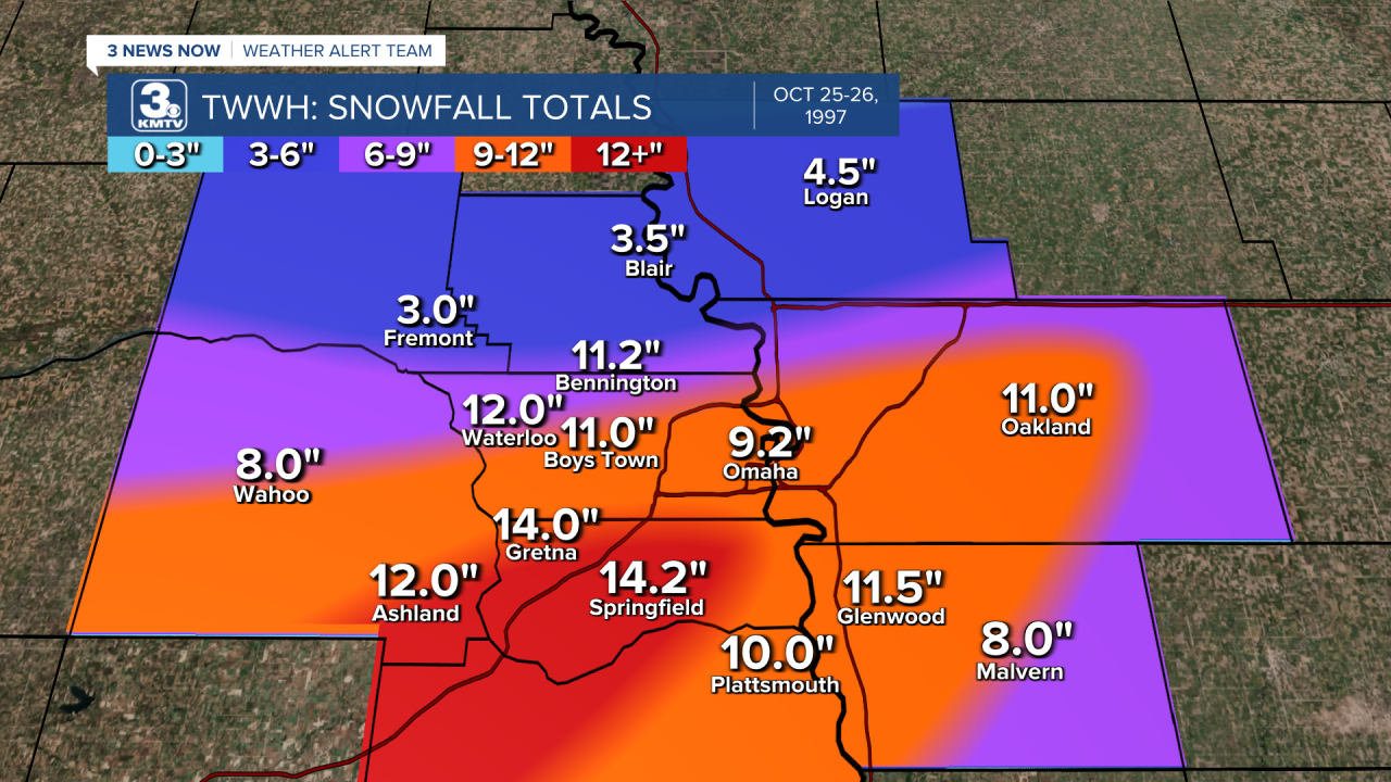
The band of heaviest snow fell in a narrow stripe from south of Kearney to Omaha to far western Iowa. The gradient was so tight that Fremont and Blair picked up only 3" of snow, while Sarpy County saw over 14" in some spots. Totals varied across the Omaha metro, with 9-12" being commonplace across much of the city.
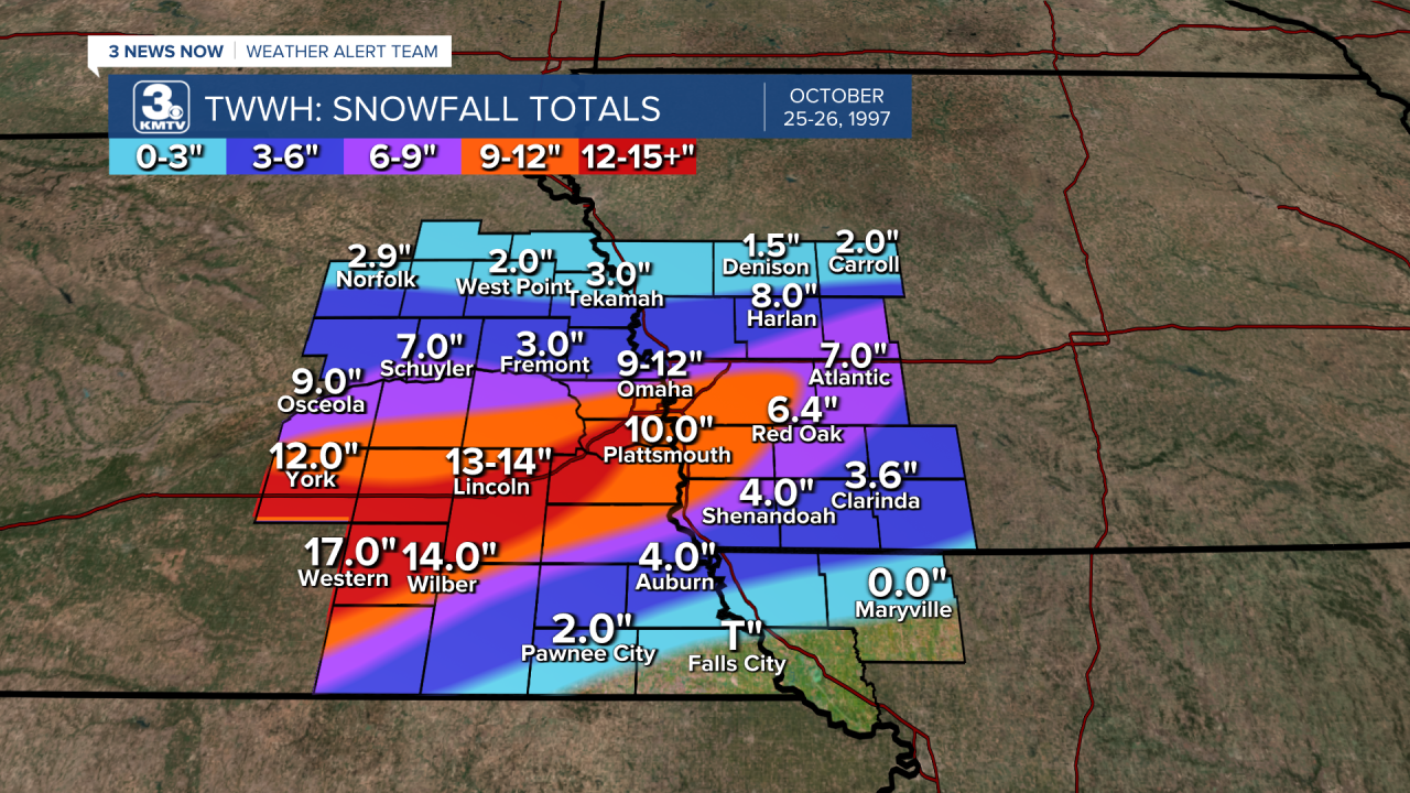
In Lincoln, 13-14" of snow was the norm, with spots in southern Lancaster County topping out at 15". By far the greater totals occurred across Saline County back towards Hastings, where 16-20" of snow fell in many spots! The highest snowfall totals in Nebraska were Clay Center, east of Hastings, at 23", and Guide Rock, near the Kansas border, at 24".
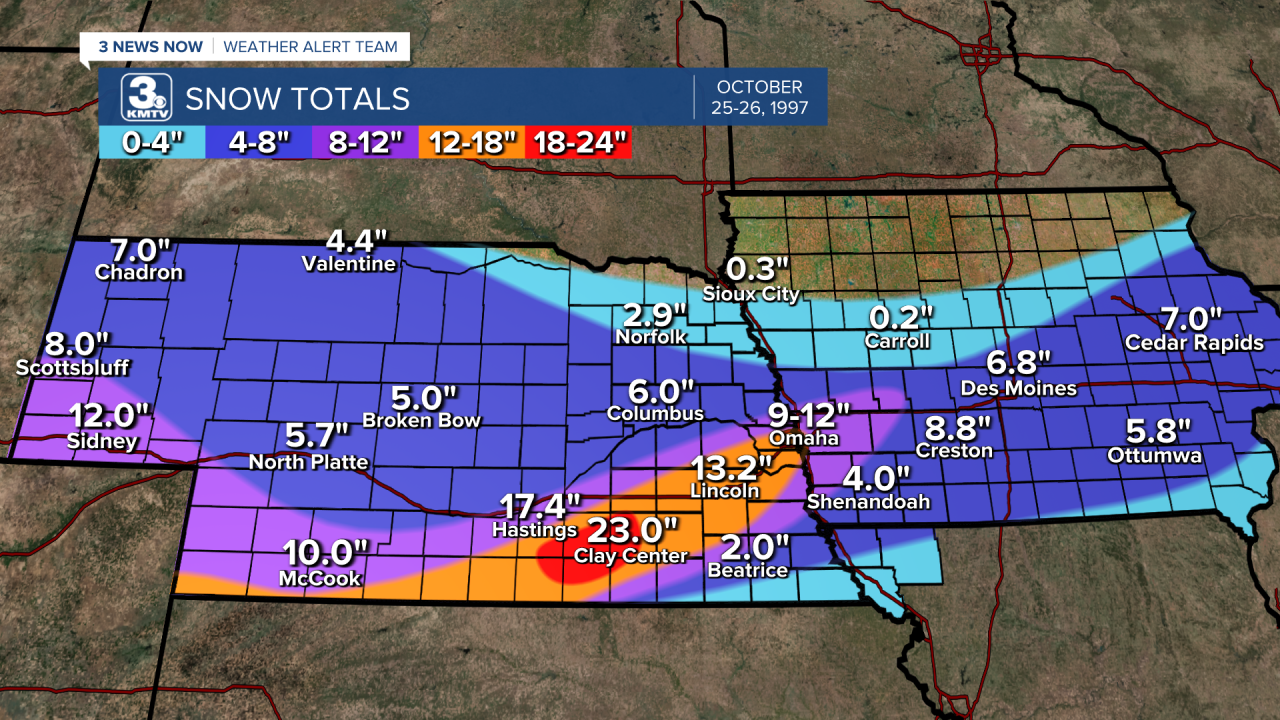
Suffice it to say that the October 1997 snowstorm shattered records for snowfall across the board. Officially, the NWS in Valley saw 9.2" of snow, breaking the old October record of 4.6" that fell in 1898. Lincoln's 13.2" smashed the old record of 6.6" in 1970. Both cities also broke monthly snowfall records for October in just 12 hours!

As the snow fell, the stress on the trees became unbearable, and many snapped. One eyewitness described the sound of tree limbs breaking as "rifle shots" that continued throughout the entire night. Even days after the storm, tree limbs that could not take the strain snapped. Power lines were sagging and snapping, either by tree limbs or from their weight. Cars were damaged, some homes had roof damage, and roadway damage was also in spots.

When residents of Omaha and Lincoln awoke on Oct. 26, the scene looked downright freaky. It was as if a massive tornado tore through the city due to tree damage. By some estimates, 85% of the trees in Omaha were either damaged or destroyed, a total not even reached by the worst thunderstorm to impact the city. The July 31 windstorm this year does not hold a candle to the amount of tree damage done in 1997. Although many trees were spared as the damage was only to limbs, around 25% of the trees across the city had to be removed.
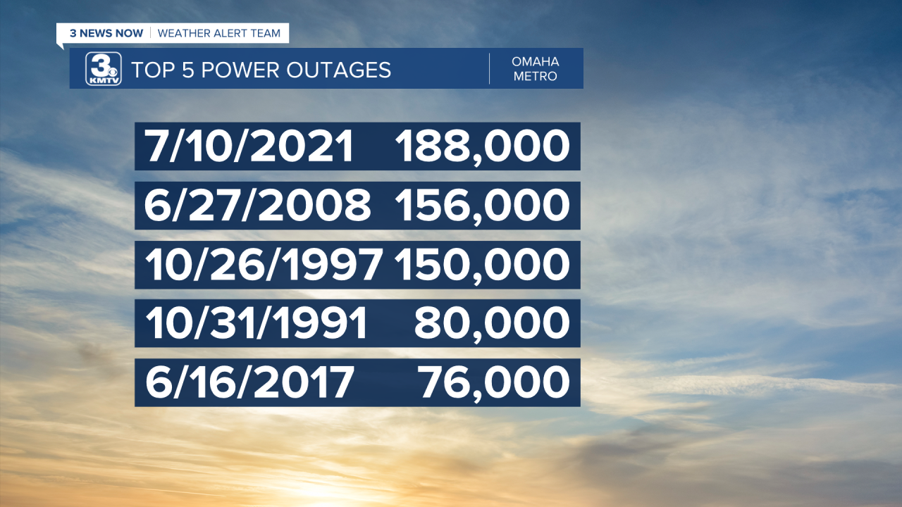
With the tree damage came the power outages. At the peak on Oct. 26, 150k customers in the Omaha metro were without power at one point or another. As "customer" means metered household, it is estimated that over 200,000 people in Omaha were without power at some point. It is the third worst power outage in Omaha history, surpassed by the July 2021 windstorm and now the July 2024 windstorm. Those without power had to wait it out in their cold homes or head to shelters for hot food and drink, which thousands did.
It took OPPD several days to fully restore power, by Halloween around 50,000 Omaha residents still had no power. Things were complicated by a series of high wind events that knocked down further power lines on Oct. 30 and Nov. 3. It took until Nov. 6 to have power restored to nearly everybody, 11 days after the snowstorm swept through.
In Lincoln, the snowfall was more significant, but the impacts were less widespread. Around 25,000 customers were knocked out of power in Lincoln, which likely meant at least 50,000 residents were without power for a time. This was the 2nd largest power outage in LPS history. Power was restored to those Lincoln residents by Nov. 3.
On Nov. 12, 39 counties across Nebraska were declared Federal Disaster Areas, including Douglas and Lancaster Counties. Eleven Iowa Counties were also declared disaster areas. According to FEMA: "The recovery efforts cost $50 million to restore power, repair cars and homes, and replant trees."

Now, 26 years later, the region has fully recovered. Many of the trees damaged in the storm recovered and have grown new branches, and those trees that were lost have been re-planted. Services like OPPD learned from the lessons of 1997 to create a better system of reporting power outages, and strengthening the infrastructure. This helped greatly in July 2021 when a major windstorm brought power outages into the hundreds of thousands once more, and again in 2024 when the July 31 windstorm knocked over 200k customers out of power.
