
As 2022 ends and we move into 2023, we look back at the wild weather that Omaha and the surrounding area saw. From strong winds, tornadoes, and drought we experienced plenty that makes 2022 a significant year for weather.
WINTER...OR LACK THEREOF
Winter in 2021 into 2022 was...underwhelming, or wonderful if you do not like snow. Omaha picked up only 10.8" of snow for the entire winter. To put this in perspective, so far this winter Omaha has picked up 4.8" of snow, meaning we have already made it halfway to beating last winter.

It was drier in Norfolk and Lincoln, with 4.1" and 5.1" respectively. In Lincoln it was the least snowy winter since 1948, and in Norfolk it was the 3rd least snowy. This trend would not relent as he headed further into the year. Already, Norfolk has beaten last year with 5.6" of snow as of January 1.
MARCH 5: EARLY SEASON TORNADO OUTBREAK IN IOWA
Severe weather season kicked off early for Iowa as a significant tornado outbreak impacted the state on March 5. The storms developed just east of Omaha and quickly raced into the central part of the state. Numerous tornadoes raced across the southern part of the state.

The most significant tornado was a long-track EF-4 (wind speeds between 166-200mph) which moved through the town of Winterset, then through the southern suburbs of Des Moines before lifting north of Newton, east of Des Moines. This 70-mile path tornado unfortunately killed 5 people, mainly in Winterset.

Another strong tornado touched down in southern Iowa, near the town of Chariton, which killed another person. This tornado was rated EF-3 (wind speeds between 136-165mph). More information can be found here
APRIL 12: TORNADOES, HEAT, AND COLD
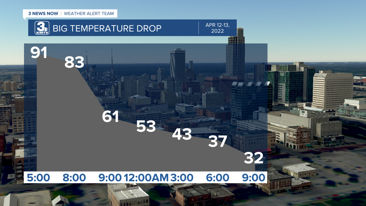
On April 12, a power storm system developed in Colorado and quickly moved its way into Nebraska, setting the stage for severe storms. Strong winds upwards of 50mph pulled in big time heat, with many regions shattering record highs for the day. Omaha reached 91 degrees, which broke the previous record of 86 degrees.
All that heat provided the fuel needed for thunderstorms, towards the evening a line of severe storms developed and brought damaging winds to much of the region. Alongside the winds, four tornadoes also touched down. One was spotted in Seward County but did little damage. An EF-1 struck Unadilla in Otoe County, and two other EF-1s touched down in Harrison County, IA.

The cold front which brought the storms also brought a major temperature change to the region. Omaha went from a record high of 91 to a low of 32, a drop of 57 degrees, close to the record temperature drop. In Lincoln and Norfolk, temperatures went from the 90s to the 20s, which is the record largest temperature drop in both cities!
APRIL 29: TORNADOES IN EASTERN NE
Numerous severe storms developed across eastern Nebraska producing numerous small tornadoes. One tornado touched down north of Schuyler, while two others touched down in Otoe County near Douglas. All of them were rated EF-1. The storms also produced damaging winds across much of the area but weakened when they moved to Omaha.

A YEAR OF WIND
We are no stranger to strong winds in this part of the country, but 2022 was a notch above our typical wind. Out of the entire year, only June, August, and October had below average wind speeds. The windiest months were March, but particularly in April where it was the 7th windiest month on record for Omaha.

The windiest day in Omaha was March 22, where the average wind speed was 23mph! On March 22, we had 17 hours of 20-45mph winds with temperatures in the 30s.
Fall 2022 also got windy again, particularly in November and December where our average wind gusts were nearly 2mph above the average.
EARLY JUNE: THREE BACK-TO-BACK SEVERE EVENTS
June is typically our most active month for severe weather, and 2022 was no different. In one week from June 7-15, Nebraska and Iowa was subjected to three rounds of strong to severe storms which brought very large hail, strong winds, and a few tornadoes.
June 7: Hail in the Omaha metro
On June 7, a hailstorm moved through parts of the Omaha metro dropping hail as large as 2" near Ralston and south Omaha. Other large hailstorms shredded crops near Waverly and further west near York. To the east, farms around Atlantic also suffered damage from hail.
June 11: Record Hail in Beatrice
On June 11, a series of supercell storms developed in Saline County and moved southeast into Gage County. In Beatrice, hail upwards of 5" in diameter fell, the size of a DVD! The hail is some of the largest seen in the area in our history. It caused significant damage across the county. The supercells also produced an EF-1 tornado near Wymore in southern Gage County.
June 15: Overnight Severe Weather
During the nighttime hours of June 14-15, one cluster of storms moved from York to just south of Omaha to near Atlantic. These storms produced large hail, very strong winds, and a few tornadoes. The worst damage was done in Seward County, where winds over 100mph drove hail to the size of baseballs into crops and buildings. Some crops in the county were so shredded it looked as if nothing was planted. The storms also produced two tornadoes, one in Cass County and another in Pottawattamie County. Read a full breakdown here.
SUMMER-FALL 2022: THE DROUGHT
Despite the occasional severe storms, summer into the fall of 2022 was dry. Many locations saw rain totals over 10" below the average rainfall amount, leading to significant drought over much of Nebraska. This has been the worst drought since 2012 in many parts of the state. It has been keenly felt in northeast Nebraska, where many locations have been under an exceptional drought for months.

To end the drought in 2023, we would need to see nearly 30" of rainfall, or just above our yearly average.
SEPTEMBER 17: LARGE HAIL IN WESTERN IOWA
Our last severe event of the year occurred in mid-September as supercells dropped significant hail in Montgomery County southeast of Red Oak, where 2" diameter hail fell near Stanton.

The largest hail fell in central Pottawattamie County, where hail over 3" fell near Carson and Oakland damaging cars. Find more information on the hail here

OCTOBER 23: WILDFIRE OUTBREAK
One of the wilder days in weather occurred on October 23, when a massive storm system brought many hazards. You can view a full breakdown here, but these are the cliff notes. We saw very strong winds through much of the day, record high temperatures with highs in the 80s, numerous wildfires which prompted evacuations in locations like Wisner, and even a lone severe storm near Norfolk.

DECEMBER: ARCTIC AIR
December 2021 was one of our warmest Decembers on record, but that flipped in December 2022. In the days leading up to Christmas, Omaha alongside much of the nation experienced a significant cold air outbreak. The worst of it came to our region on December 22, where the actual air temperature in Omaha reached -14 degrees. Compounding it was the very strong winds, which brought our wind chill as cold as -40 to -45 at times! This is rare for the region, with Omaha only experiencing a handful of times we have seen wind chills below -40.


Luckily, we thawed as we ended the year, with New Year's Eve ending in the 40s! Now we look ahead to 2023 to see what the weather has in store for us.
